File:Moldova Transnistria locator.svg
Jump to navigation
Jump to search

Size of this PNG preview of this SVG file: 488 × 600 pixels. Other resolutions: 195 × 240 pixels | 390 × 480 pixels | 625 × 768 pixels | 833 × 1,024 pixels | 1,666 × 2,048 pixels | 990 × 1,217 pixels.
Original file (SVG file, nominally 990 × 1,217 pixels, file size: 190 KB)
Captions
Captions
Add a one-line explanation of what this file represents
Summary[edit]
| Description |
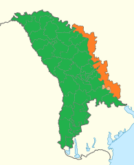
English: Location of Moldova and de facto Transnistria |
||
| Date | |||
| Source | Transnistria in Moldova (de-facto).svg | ||
| Author |
|
||
| Permission (Reusing this file) |
|
||
| Other versions | Moldova Transnistria locator.png |
.svg)
File history
Click on a date/time to view the file as it appeared at that time.
| Date/Time | Thumbnail | Dimensions | User | Comment | |
|---|---|---|---|---|---|
| current | 13:49, 8 January 2020 | | 990 × 1,217 (190 KB) | Hogweard (talk | contribs) | {{Information |description={{en|1=Location of Moldova and de facto Transnistria}} |date=2020-01-08 |source={{f|Transnistria in Moldova (de-facto).svg}} |author=*{{f|Transnistria in Moldova (de-facto).svg}}: {{u|TUBS}} *Derivative work: {{u|Hogweard}} |permission={{PD-self}} |other versions={{f|Moldova Transnistria locator.png}} }} Category:Maps of Moldova Category:Bilateral maps of Moldova Category:Maps of Transnistria Category:Bilateral maps of Transnistria |
You cannot overwrite this file.
File usage on Commons
There are no pages that use this file.
File usage on other wikis
The following other wikis use this file:
- Usage on el.wiktionary.org
- Usage on en.wikipedia.org
- Usage on fr.wikipedia.org
- Usage on ro.wikipedia.org