File:Montes Taurus (GLD100).jpg
Jump to navigation
Jump to search
Size of this preview: 600 × 600 pixels. Other resolutions: 240 × 240 pixels | 480 × 480 pixels | 768 × 768 pixels | 1,024 × 1,024 pixels | 2,048 × 2,048 pixels | 2,948 × 2,948 pixels.
Original file (2,948 × 2,948 pixels, file size: 1.44 MB, MIME type: image/jpeg)
Captions
Captions
Add a one-line explanation of what this file represents
Summary[edit]
.jpg&action=edit§ion=1)
| Description |
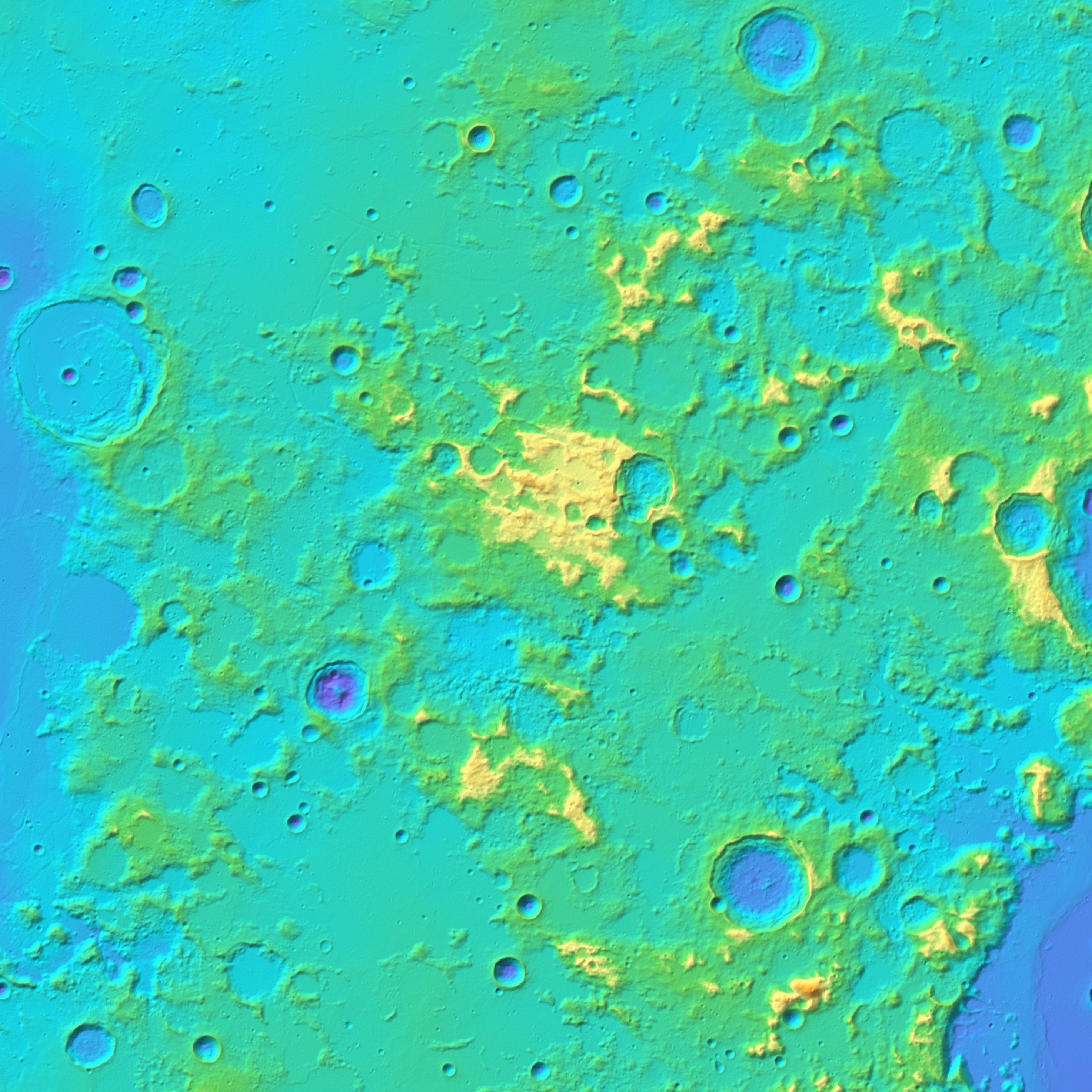
Українська: Таврські гори на Місяці, на схід від Моря Ясності. Карта висот, складена за топографічною моделлю Місяця GLD100 (Global Lunar DTM 100 m topographic model), побудованою за даними космічного апарату Lunar Reconnaissance Orbiter. Розмір зображення — 700×700 км, північ угорі. Поле зору та роздільна здатність такі самі, як у мозаїки знімків Montes Taurus (LRO).png. English: Montes Taurus on the Moon, to the east from Mare Serenitatis. Topographic map (color shaded relief), based on Global Lunar DTM 100 m topographic model (GLD100), which is based on data acquired by Lunar Reconnaissance Orbiter. Size of the image is 700×700 km, north is up. The image has the same span and resolution as a photomosaic Montes Taurus (LRO).png. |
| Date | |
| Source | JMARS |
| Author | NASA (image by Lunar Reconnaissance Orbiter) |
.png)
Licensing[edit]
.jpg&action=edit§ion=2)
| This file is in the public domain in the United States because it was solely created by NASA. NASA copyright policy states that "NASA material is not protected by copyright unless noted". (See Template:PD-USGov, NASA copyright policy page or JPL Image Use Policy.) | ||
 |
Warnings:
|
File history
Click on a date/time to view the file as it appeared at that time.
| Date/Time | Thumbnail | Dimensions | User | Comment | |
|---|---|---|---|---|---|
| current | 10:13, 16 February 2015 | | 2,948 × 2,948 (1.44 MB) | Sneeuwschaap (talk | contribs) | User created page with UploadWizard |
You cannot overwrite this file.
File usage on Commons
There are no pages that use this file.
File usage on other wikis
The following other wikis use this file:
- Usage on ca.wikipedia.org
- Usage on en.wikipedia.org
- Usage on es.wikipedia.org
- Usage on ru.wikipedia.org
- Usage on uk.wikipedia.org
- Usage on zh.wikipedia.org
.jpg&oldid=426389466)