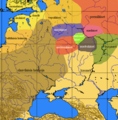
File:Muromian-map.png
Jump to navigation
Jump to search

Size of this preview: 588 × 600 pixels. Other resolutions: 235 × 240 pixels | 610 × 622 pixels.
Original file (610 × 622 pixels, file size: 165 KB, MIME type: image/png)
Captions
Captions
Add a one-line explanation of what this file represents

|
File:Finno-ugrian-map.svg is a vector version of this file. It should be used in place of this PNG file when not inferior.
File:Muromian-map.png → File:Finno-ugrian-map.svg
For more information, see Help:SVG. |
 |
Summary
[edit]| Description |
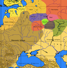
English: An approximate ethno-linguistic map of Kievan Rus' in the 9th century: Five Volga Finnic groups of the Merya, Mari, Muromians, Meshchera and Mordvins are shown as surrounded by the Slavs to the west; the three Finnic groups of the Veps, Ests and Chuds, and Indo-European Balts to the northwest; the Permians to the northeast the (Turkic) Bulgars and Khazars to the southeast and south. |
| Source | File:Finno-ugrian-map.svg states that it is based on Рябинин Е. А. Финно-угорские племена в составе Древней Руси. |
| Author | Wiglaf. |
Licensing
[edit]
|
Permission is granted to copy, distribute and/or modify this document under the terms of the GNU Free Documentation License, Version 1.2 or any later version published by the Free Software Foundation; with no Invariant Sections, no Front-Cover Texts, and no Back-Cover Texts. A copy of the license is included in the section entitled GNU Free Documentation License. |
| This file is licensed under the Creative Commons Attribution-Share Alike 3.0 Unported license. | ||
| ||
| This licensing tag was added to this file as part of the GFDL licensing update. |
Other versions
[edit]-
 Español
 -
 Italiano
 -
 Srpski
 -
 suomi
suomi


File history
Click on a date/time to view the file as it appeared at that time.
| Date/Time | Thumbnail | Dimensions | User | Comment | |
|---|---|---|---|---|---|
| current | 13:47, 9 October 2016 | | 610 × 622 (165 KB) | Julieta39 (talk | contribs) | No Soviet dam reservoirs 1000 years ago, and differentiation between "Danube-" and "Volga-" Bulgars |
| 00:07, 9 March 2013 |  | 610 × 622 (164 KB) | Martintg (talk | contribs) | Located Chudes based upon academic sources | |
| 23:10, 10 December 2007 |  | 610 × 622 (144 KB) | Incnis Mrsi (talk | contribs) | There was no such thing as w:en:Rybinsk Reservoir before "Slavonic tribes" came ☺ | |
| 11:01, 6 October 2006 |  | 610 × 622 (113 KB) | Mets501 (talk | contribs) | fix tribe name (vepses --> veps) | |
| 13:07, 7 December 2005 |  | 610 × 622 (145 KB) | Joonasl (talk | contribs) | From en-wiki by [http://en.wikipedia.org/wiki/User:Wiglaf Wiglaf]. Category:Uralic languages {{GFDL}} |
You cannot overwrite this file.
File usage on Commons
The following 9 pages use this file:
File usage on other wikis
The following other wikis use this file:
- Usage on af.wikipedia.org
- Usage on ang.wikipedia.org
- Usage on be-tarask.wikipedia.org
- Usage on be.wikipedia.org
- Usage on bg.wikipedia.org
- Usage on br.wikipedia.org
- Usage on ca.wikipedia.org
- Usage on cs.wikipedia.org
- Usage on cv.wikipedia.org
- Usage on da.wikipedia.org
- Usage on da.wikibooks.org
- Usage on el.wikipedia.org
- Usage on en.wikipedia.org
- Usage on eo.wikipedia.org
- Usage on es.wikipedia.org
- Usage on et.wikipedia.org
- Usage on eu.wikipedia.org
View more global usage of this file.
Metadata
Categories:
- Maps of the history of Georgia
- Linguistic maps of eastern Europe
- Linguistic maps of Uralic languages
- Maps of ethnic groups in Europe
- History of ethnic groups in Russia
- English-language linguistic maps
- Maps of the history of Estonia
- Maps of the East Slavs
- Maps showing history of the Early Middle Ages
- Maps showing the history of languages
- Maps of the history of Central Europe
- Mari people
- Vepsians
- Chud people
- Volga Finns
- Muroma culture