File:NZ-ManukauCity.png
Jump to navigation
Jump to search

Size of this preview: 504 × 600 pixels. Other resolutions: 202 × 240 pixels | 589 × 701 pixels.
Original file (589 × 701 pixels, file size: 90 KB, MIME type: image/png)
Captions
Captions
Add a one-line explanation of what this file represents
Summary[edit]
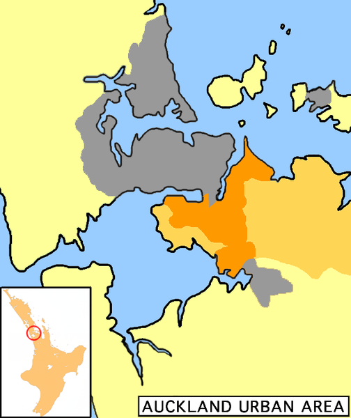
| Description | Uploaded from the English Wikipedia, uploaded there by user:Grutness: Map of Auckland urban area, Manukau City highlighted (dark orange=populated; light orange=rural areas). |
| Date | 27 May 2006 (original upload date) |
| Source | No machine-readable source provided. Own work assumed (based on copyright claims). |
| Author | No machine-readable author provided. 2000 assumed (based on copyright claims). |
Licensing[edit]
| I, the copyright holder of this work, release this work into the public domain. This applies worldwide. In some countries this may not be legally possible; if so: I grant anyone the right to use this work for any purpose, without any conditions, unless such conditions are required by law. |
File history
Click on a date/time to view the file as it appeared at that time.
| Date/Time | Thumbnail | Dimensions | User | Comment | |
|---|---|---|---|---|---|
| current | 14:43, 27 May 2006 | | 589 × 701 (90 KB) | 2000 (talk | contribs) | == Summary == Uploaded from the English Wikipedia, uploaded there by user:Grutness Map of Auckland urban area, Manukau City highlighted (dark orange=populated; light orange=rural areas) Category:Maps of New Zealand Category:Auckland [[Categor |
You cannot overwrite this file.
File usage on Commons
The following page uses this file:
File usage on other wikis
The following other wikis use this file:
- Usage on az.wikipedia.org
- Usage on ceb.wikipedia.org
- Usage on el.wikipedia.org
- Usage on en.wikipedia.org
- Usage on es.wikipedia.org
- Usage on fa.wikipedia.org
- Usage on fr.wikipedia.org
- Usage on id.wikipedia.org
- Usage on it.wikipedia.org
- Usage on nl.wikipedia.org
- Usage on nn.wikipedia.org
- Usage on pl.wikipedia.org
- Usage on pt.wikipedia.org
- Usage on ro.wikipedia.org
- Usage on vo.wikipedia.org
- Usage on www.wikidata.org
- Usage on zh.wikipedia.org