File:Neckar river watershed.png
Jump to navigation
Jump to search
Size of this preview: 484 × 600 pixels. Other resolutions: 194 × 240 pixels | 514 × 637 pixels.
Original file (514 × 637 pixels, file size: 14 KB, MIME type: image/png)
Captions
Captions
Add a one-line explanation of what this file represents

|
This map image could be re-created using vector graphics as an SVG file. This has several advantages; see Commons:Media for cleanup for more information. If an SVG form of this image is available, please upload it and afterwards replace this template with
{{vector version available|new image name}}.
It is recommended to name the SVG file “Neckar river watershed.svg”—then the template Vector version available (or Vva) does not need the new image name parameter. |
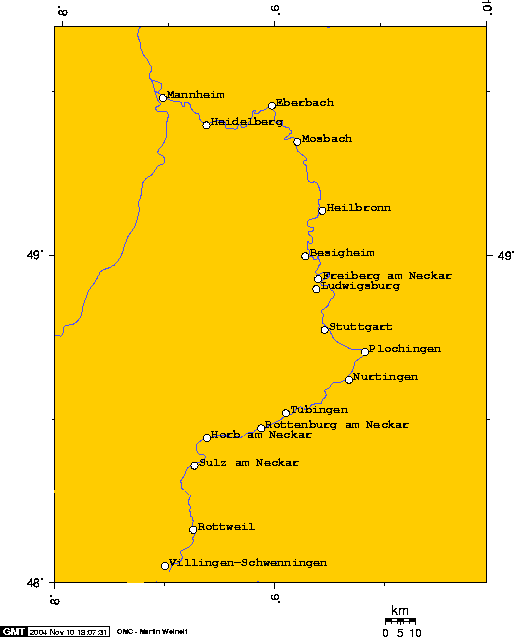
Watershed of the Neckar River
Source: Englis wikipedia (see interwiki)
The author (Geo Swan) declares this image GFDL. Uploaded 2004-11-09T03:41:50.

|
Permission is granted to copy, distribute and/or modify this document under the terms of the GNU Free Documentation License, Version 1.2 or any later version published by the Free Software Foundation; with no Invariant Sections, no Front-Cover Texts, and no Back-Cover Texts. A copy of the license is included in the section entitled GNU Free Documentation License. |
| This file is licensed under the Creative Commons Attribution-Share Alike 3.0 Unported license. | ||
| ||
| This licensing tag was added to this file as part of the GFDL licensing update. |
| I, the copyright holder of this work, release this work into the public domain. This applies worldwide. In some countries this may not be legally possible; if so: I grant anyone the right to use this work for any purpose, without any conditions, unless such conditions are required by law. |
The author says:
I used this online map creation tool to create this map. In case it becomes necessary to modify this map these are the longitude and latitude I used to create this map. Geo Swan 04:07, 9 Nov 2004 (UTC)
- 8.4800,48.0553, Villingen-Schwenningen
- 8.6281,48.1667, Rottweil
- 8.6318,48.3624, Sulz am Neckar
- 8.6900,48.4465, Horb am Neckar
- 8.9377,48.4769, Rottenburg am Neckar
- 9.0521,48.5229, Tübingen
- 9.3426,48.6246, Nurtingen
- 9.4173,48.7098, Plochingen
- 9.2000,48.7772, Stuttgart
- 9.1934,48.9020, Ludwigsburg
- 9.2025,48.9324, Freiberg am Neckar
- 9.1421,49.0023, Besigheim
- 9.2221,49.1416, Heilbronn
- 9.1459,49.3520, Mosbach
- 8.9871,49.4624, Eberbach
- 8.6802,49.4019, Heidelberg
- 8.4757,49.4845, Mannheim
File history
Click on a date/time to view the file as it appeared at that time.
| Date/Time | Thumbnail | Dimensions | User | Comment | |
|---|---|---|---|---|---|
| current | 16:51, 13 November 2004 | | 514 × 637 (14 KB) | Mschlindwein (talk | contribs) | Neckar Watershed |
You cannot overwrite this file.
File usage on Commons
The following 4 pages use this file:
File usage on other wikis
The following other wikis use this file:
- Usage on ar.wikipedia.org
- Usage on azb.wikipedia.org
- Usage on de.wikipedia.org
- Usage on de.wiktionary.org
- Usage on el.wikipedia.org
- Usage on en.wikipedia.org
- Usage on eo.wikipedia.org
- Usage on fa.wikipedia.org
- Usage on fi.wikipedia.org
- Usage on fr.wikipedia.org
- Usage on gl.wikipedia.org
- Usage on hu.wikipedia.org
- Usage on id.wikipedia.org
- Usage on it.wikipedia.org
- Usage on jv.wikipedia.org
- Usage on lmo.wikipedia.org
- Usage on lv.wikipedia.org
- Usage on pl.wikipedia.org
- Usage on pt.wikipedia.org
- Usage on tr.wikipedia.org
- Usage on vi.wikipedia.org