File:Neufrankreich.svg
Vai alla navigazione
Vai alla ricerca

Dimensioni di questa anteprima PNG per questo file SVG: 800 × 570 pixel. Altre risoluzioni: 320 × 228 pixel | 640 × 456 pixel | 1 024 × 730 pixel | 1 280 × 912 pixel | 2 560 × 1 824 pixel | 1 530 × 1 090 pixel.
File originale (file in formato SVG, dimensioni nominali 1 530 × 1 090 pixel, dimensione del file: 694 KB)
Didascalie
Didascalie
Aggiungi una brevissima spiegazione di ciò che questo file rappresenta
Dettagli
[modifica]| Descrizione |
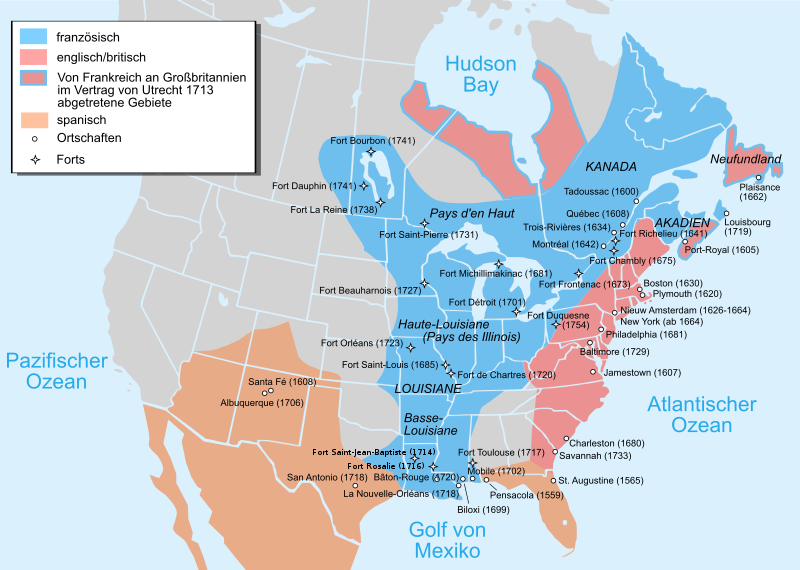
Català: Mapa de la Nova França sobre 1754-1755 English: Map of New France about 1750 using modern political boundaries Español: Mapa de la Nueva Francia cerca de 1750. Français : Carte de la Nouvelle-France vers 1754-1755 Norsk nynorsk: Kart over Ny Frankrike (ca 1754-1755) Русский: Карта Французских колоний в Америке 1750 中文(中国大陆): 1750年左右的新法兰西地图,附现代边界。 العربية : خريطة فرنسا الجديدة حوالي عام 1750 باستخدام الحدود السياسية الحديثة |
||
| Data | (UTC) | ||
| Fonte |
Questo file deriva da:
EquiDistantConicProjection : Central parallel : * N: 37.0° N Central meridian : * E: 96.0° W Standard parallels: * 1: 32.0° N * 2: 42.0° N Made with Natural Earth. Free vector and raster map data @ naturalearthdata.com. Formulas for x and y: x = 50.0 + 124.03149777329222 * ((1.9694462586094064-({{{2}}}* pi / 180)) * sin(0.6010514667026994 * ({{{3}}} + 96) * pi / 180)) y = 50.0 + 1.6155950752393982 * 124.03149777329222 * 0.02613325650382181 - 1.6155950752393982 * 124.03149777329222 * (1.3236744353715044 - (1.9694462586094064-({{{2}}}* pi / 180)) * cos(0.6010514667026994 * ({{{3}}} + 96) * pi / 180))
|
||
| Autore |
Il codice sorgente di questo file SVG non è valido a causa di 57 errori. Questa mappa in grafica vettoriale non valida secondo il W3C è stata creata con Adobe Illustrator. |
||
| Altre versioni |
[]
|


| Questa è una immagine ritoccata, il che significa che è stata modificata digitalmente dalla sua versione originale. Modifiche: added Mexico, translated to German. La versione originale può essere vista qui: Usa edcp location map.svg. Le modifiche sono di Bamse.
|
Licenza
[modifica]
Questo file è disponibile in base alla licenza Creative Commons Attribuzione-Condividi allo stesso modo 3.0 Unported
- Tu sei libero:
- di condividere – di copiare, distribuire e trasmettere quest'opera
- di modificare – di adattare l'opera
- Alle seguenti condizioni:
- attribuzione – Devi fornire i crediti appropriati, un collegamento alla licenza e indicare se sono state apportate modifiche. Puoi farlo in qualsiasi modo ragionevole, ma non in alcun modo che suggerisca che il licenziante approvi te o il tuo uso.
- condividi allo stesso modo – Se remixi, trasformi o sviluppi il materiale, devi distribuire i tuoi contributi in base alla stessa licenza o compatibile all'originale.
Registro originale del caricamento
[modifica]
This image is a derivative work of the following images:
- File:Nouvelle-France_map-fr.svg licensed with Cc-by-sa-3.0,2.5,2.0,1.0, GFDL
- 2011-12-03T22:43:05Z JF Lepage 1530x1090 (333614 Bytes) Reverted to version as of 18:04, 13 November 2007
- 2011-12-01T12:21:39Z Hypersite 1550x1100 (348037 Bytes) Agrandie
- 2011-12-01T12:19:24Z Hypersite 1530x1090 (348037 Bytes) Agrandie
- 2011-12-01T12:15:49Z Hypersite 744x1052 (347994 Bytes) Vraie taille de la Nouvelle-France, Version améliorée,Ajout de 80 sources pour un délimitation des frontière la plus exacte possible. (Quand a la polémique disant que sont territoire s'étendait jusque en Oregon et Oc�
- 2011-12-01T12:12:54Z Hypersite 744x1052 (347978 Bytes) Vraie taille de la Nouvelle-France, Version améliorée,Ajout de 80 sources pour un délimitation des frontière la plus exacte possible. (Quand a la polémique disant que sont territoire s'étendait jusque en Oregon et Oc�
- 2007-11-13T18:04:41Z Pinpin 1530x1090 (333614 Bytes) illinois=>Illinois
- 2007-10-20T08:10:28Z Pinpin 1530x1090 (333613 Bytes)
- 2007-10-10T18:59:28Z Pinpin 1530x1090 (333619 Bytes)
- 2007-10-10T07:48:33Z Pinpin 1530x1090 (333620 Bytes)
- 2007-10-05T06:26:34Z Pinpin 1530x1090 (333485 Bytes)
- 2007-10-04T23:51:17Z Pinpin 1530x1090 (334013 Bytes)
- 2007-10-04T23:49:21Z Pinpin 1530x1090 (334112 Bytes) + legend
- 2007-10-04T23:38:23Z Pinpin 1530x1090 (326455 Bytes) {{Information |Description={{fr|Carte de la Nouvelle-France vers 1750}} {{en|Map of the New-France about 1750.}} |Source=travail personnel from [[:Image:Nouvelle-France1750.png]] 1)Les Villes françaises du Nouveau Monde : de
- File:Usa_edcp_location_map.svg licensed with Cc-by-sa-3.0, GFDL
- 2010-08-24T17:56:50Z Uwe Dedering 1181x731 (2691477 Bytes) coastline was to thin and bahamas pulled out of the atlantic
- 2010-08-24T10:35:14Z Uwe Dedering 1181x731 (3648408 Bytes) {{Information |Description={{en|1=Location map of the USA (without Hawaii and Alaska). EquiDistantConicProjection : Central parallel : * N: 37.0° N Central meridian : * E: 96.0° W Standard parallels: * 1: 32.0° N * 2:
Uploaded with derivativeFX
Cronologia del file
Fare clic su un gruppo data/ora per vedere il file come si presentava nel momento indicato.
| Data/Ora | Miniatura | Dimensioni | Utente | Commento | |
|---|---|---|---|---|---|
| attuale | 16:12, 14 dic 2022 | | 1 530 × 1 090 (694 KB) | Tcr25 (discussione | contributi) | Fort Rosaile in wrong location; add Fort St-Jean-Baptiste |
| 00:20, 9 ott 2013 |  | 1 530 × 1 090 (924 KB) | Furfur (discussione | contributi) | Schraffur ist verlorengegangen, stattdessen vielleicht Umrandung ? | |
| 23:31, 8 ott 2013 |  | 1 530 × 1 090 (902 KB) | Furfur (discussione | contributi) | kosmetische Änderungen (Diskussion Kartenwerkstatt) | |
| 14:14, 31 gen 2012 |  | 1 530 × 1 090 (316 KB) | Bamse (discussione | contributi) | update per comments in Kartenwerkstatt | |
| 20:40, 29 gen 2012 |  | 1 530 × 1 090 (316 KB) | Bamse (discussione | contributi) | error fixes per discussion in Kartenwerkstatt | |
| 21:05, 28 gen 2012 |  | 1 530 × 1 090 (316 KB) | Bamse (discussione | contributi) | extended Spain to Mexico, added some towns and fixed some errors | |
| 10:54, 28 gen 2012 |  | 1 530 × 1 090 (307 KB) | Bamse (discussione | contributi) | == {{int:filedesc}} == {{Information |Description={{fr|Carte de la Nouvelle-France vers 1750 - version française}} {{en|Map of the New-France about 1750 - French Version}} {{en|1=Location map of the USA (without Hawaii and Alaska). EquiDistantConicProjec |
Impossibile sovrascrivere questo file.
Utilizzo del file
Le seguenti 12 pagine usano questo file:
- File:Neufrankreich.svg
- File:Nouvelle-France map-ar.svg
- File:Nouvelle-France map-ca.svg
- File:Nouvelle-France map-en.svg
- File:Nouvelle-France map-es.svg
- File:Nouvelle-France map-fr.svg
- File:Nouvelle-France map-he.svg
- File:Nouvelle-France map-ru.svg
- File:Nouvelle-France map-zh-hans.svg
- File:USA edcp location map lite.svg
- File:Usa edcp location map.svg
- Template:Other versions/Nouvelle-France map
Utilizzo globale del file
Anche i seguenti wiki usano questo file:
- Usato nelle seguenti pagine di de.wikipedia.org:
- Shawnee
- Neufrankreich
- Louisiana (Kolonie)
- Miami (Volk)
- Indianerkriege
- Siebenjähriger Krieg in Nordamerika
- Onondaga
- Fort Michilimackinac
- Winnebago (Volk)
- Geschichte Québecs
- Wirtschaftsgeschichte Kanadas
- Geschichte Louisianas
- Wikipedia:Kartenwerkstatt/Archiv/2012-02
- Menominee (Volk)
- Wikipedia:Kartenwerkstatt/Archiv/2013-10
- Schweizer Truppen in französischen Diensten für das Königshaus der Bourbonen 1589–1792
- The Jesuit Relations and Allied Documents
- Beziehungen zwischen Kanada und den Vereinigten Staaten
- Usato nelle seguenti pagine di en.wikipedia.org:
- Usato nelle seguenti pagine di it.wikipedia.org:
Metadati
Categorie:
- Maps of New France
- Maps of colonial North America
- Maps of the history of Canada
- Maps of the history of the United States
- Maps of the Viceroyalty of New Spain
- SVG maps of the history of Mexico
- Locator maps of former territories
- North America in the 1750s
- Canada in the 1750s
- United States in the 1750s
- New Mexico in the 1750s
- French and Indian War
- Treaty of Utrecht