File:Norad map.png
Jump to navigation
Jump to search
No higher resolution available.
Norad_map.png (702 × 326 pixels, file size: 55 KB, MIME type: image/png)
Captions
Captions
Add a one-line explanation of what this file represents
| Description |
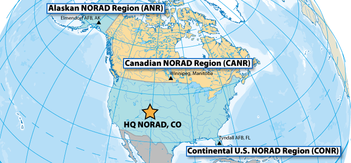
Français : La zone opérationnelle du NORAD est divisée en trois régions. L'Alaskan Norad Region, le Canadian Norad et le Continental U.S Norad. |
||||||
| Date | Unknown date | ||||||
| Source | http://www.noradsanta.org/fr/anorad.html | ||||||
| Author | Unknown author | ||||||
| Permission (Reusing this file) |
|
||||||

File history
Click on a date/time to view the file as it appeared at that time.
| Date/Time | Thumbnail | Dimensions | User | Comment | |
|---|---|---|---|---|---|
| current | 06:40, 17 October 2010 | | 702 × 326 (55 KB) | L'amateur d'aéroplanes (talk | contribs) | {{Information |Description={{fr|1=La zone opérationnelle du NORAD est divisée en trois régions. L'Alaskan Norad Region, le Canadian Norad et le Continental U.S Norad. }} |Source=http://www.noradsanta.org/fr/anorad.html |Author=Inconnu |Date=Inconnu |P |
You cannot overwrite this file.
File usage on Commons
There are no pages that use this file.
File usage on other wikis
The following other wikis use this file:
- Usage on ca.wikipedia.org
- Usage on de.wikipedia.org
- Usage on es.wikipedia.org
- Usage on fi.wikipedia.org
- Usage on fr.wikipedia.org
- Usage on it.wikipedia.org
- Usage on nl.wikipedia.org
- Usage on pl.wikipedia.org
- Usage on ro.wikipedia.org
- Usage on vi.wikipedia.org