File:Nowy Świat canal map pl.png
Jump to navigation
Jump to search
Size of this preview: 800 × 447 pixels. Other resolutions: 320 × 179 pixels | 640 × 357 pixels | 1,024 × 572 pixels | 1,462 × 816 pixels.
Original file (1,462 × 816 pixels, file size: 324 KB, MIME type: image/png)
Captions
Captions
Add a one-line explanation of what this file represents
Summary[edit]
| Description |
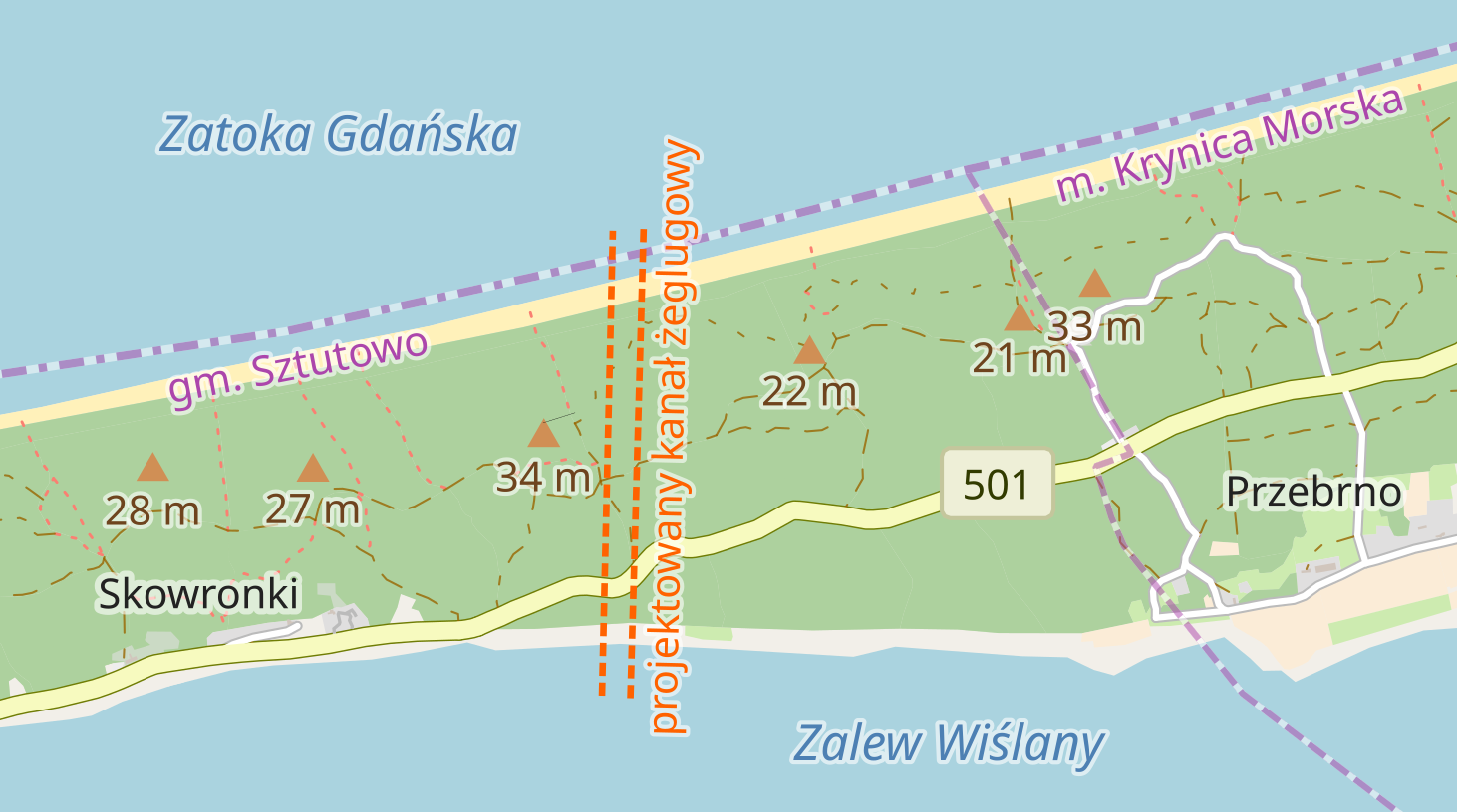
English: Location of a proposed Nowy Świat canal connecting Gdańsk Bay and Vistula Lagoon across Vistula Spit. |
| Date | |
| Source | The background are edited OpenStreetMap tiles. The location is taken from the feasibility study "Budowa kanału żeglugowego przez Mierzeję Wiślaną. Koncepcja techniczna i kosztowa..." by K. Mioduszewski and B. Zrzelska (available on the website of maritime administration office in Gdynia [1]). |
| Author | OpenStreetMap contributors, edited by User:Dwie szyszki |
| Description |
Location of a proposed Nowy Świat canal connecting Gdańsk Bay and Vistula Lagoon across Vistula Spit. This map of western part of Vistula Spit was created from OpenStreetMap project data, collected by the community. This map may be incomplete, and may contain errors. Don't rely solely on it for navigation. |
|||||||||
| Date | ||||||||||
| Source | You may find a page on the OpenStreetMap wiki page for Nowy Świat canal | |||||||||
| Creator |
OpenStreetMap contributors, edited by User:Dwie szyszki OpenStreetMap contributors |
|||||||||
| Permission (Reusing this file) |
OpenStreetMap data is available under the Open Database License (details). Map tiles are licensed under the Creative Commons Attribution-ShareAlike 2.0 license (CC-BY-SA 2.0).
This file is licensed under the Creative Commons Attribution-Share Alike 2.0 Generic license.
|
|||||||||
| Geotemporal data | ||||||||||
| Bounding box |
|
|||||||||
| Georeferencing | If inappropriate please set warp_status = skip to hide. | |||||||||
| Other versions |
English language version:  |
|||||||||
File history
Click on a date/time to view the file as it appeared at that time.
| Date/Time | Thumbnail | Dimensions | User | Comment | |
|---|---|---|---|---|---|
| current | 22:37, 17 September 2018 | | 1,462 × 816 (324 KB) | Dwie szyszki (talk | contribs) | == {{int:filedesc}} == {{Information |description ={{en|1=Location of a proposed ''Nowy Świat'' canal connecting Gdańsk Bay and Vistula Lagoon across Vistula Spit. }} |date =2018-09-18 |source =The background are edited OpenStreetMap tiles. The route is taken from the environmental impact assessment "Karta informacyjna przedsięwzięcia „Droga wodna łącząca Zalew Wiślany z Zatoką Gdańską - lokalizacja Nowy Świat”" [http://www.umgdy.gov.pl/wp-content/uploads/2015/07/TI_Karta_In... |
You cannot overwrite this file.
File usage on Commons
There are no pages that use this file.
File usage on other wikis
The following other wikis use this file:
- Usage on lt.wikipedia.org
- Usage on lv.wikipedia.org
- Usage on pl.wikipedia.org
- Usage on ru.wikipedia.org