File:Nyanga OSM.png
Jump to navigation
Jump to search

Size of this preview: 800 × 534 pixels. Other resolutions: 320 × 213 pixels | 640 × 427 pixels | 1,024 × 683 pixels | 1,280 × 854 pixels | 2,102 × 1,402 pixels.
Original file (2,102 × 1,402 pixels, file size: 5.74 MB, MIME type: image/png)
Captions
Captions
Add a one-line explanation of what this file represents
Summary[edit]
| Description |
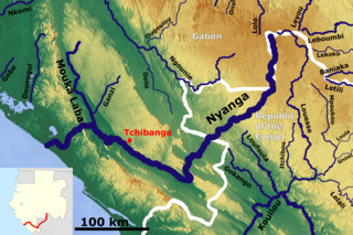
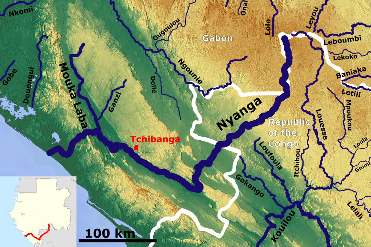
English: The Nyanga catchment OSM, Based up on US Army map SA32-33 |
| Date | |
| Source | https://maps-for-free.com/, https://maps.lib.utexas.edu/maps/imw/, Location map:https://commons.wikimedia.org/wiki/File:Gabon_location_map.svg |
| Author | Hans Braxmeier & Peter in s, Location map:Uwe Dedering |
This file is licensed under the Creative Commons Attribution-Share Alike 3.0 Unported license.
- You are free:
- to share – to copy, distribute and transmit the work
- to remix – to adapt the work
- Under the following conditions:
- attribution – You must give appropriate credit, provide a link to the license, and indicate if changes were made. You may do so in any reasonable manner, but not in any way that suggests the licensor endorses you or your use.
- share alike – If you remix, transform, or build upon the material, you must distribute your contributions under the same or compatible license as the original.
File history
Click on a date/time to view the file as it appeared at that time.
| Date/Time | Thumbnail | Dimensions | User | Comment | |
|---|---|---|---|---|---|
| current | 08:41, 31 October 2020 | | 2,102 × 1,402 (5.74 MB) | Peter in s (talk | contribs) | new |
| 06:10, 11 December 2018 |  | 780 × 491 (754 KB) | Peter in s (talk | contribs) | {{Information |description ={{en|1=The Nyanga catchment OSM}} |date =2018-12-11 |source =https://maps-for-free.com/ |author =Hans Braxmeier }} {{cc-by-sa-2.0}} Category:Rivers of Gabon Category:Rivers of the Republic of the Congo |
You cannot overwrite this file.
File usage on Commons
The following page uses this file:
File usage on other wikis
The following other wikis use this file:
- Usage on de.wikipedia.org
- Usage on en.wikipedia.org
- Usage on es.wikipedia.org
- Usage on ff.wikipedia.org
- Usage on fr.wikipedia.org
- Usage on ha.wikipedia.org
- Usage on lt.wikipedia.org
- Usage on www.wikidata.org