File:Old map of Monmouth, Wales.jpg

Original file (2,269 × 1,774 pixels, file size: 1.17 MB, MIME type: image/jpeg)
Captions
Captions
Summary
[edit]
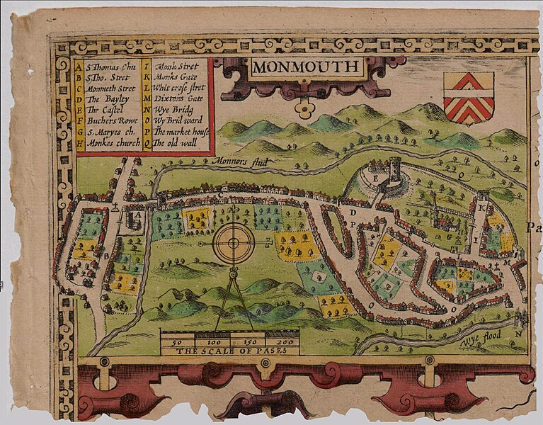
John Speed's Map of Monmouth, Wales, 1610. No copyright, public domain.
Source: Part of: The Countye of Monmouth
Licensing
[edit]
This image is in the public domain because it is a mere mechanical scan or photocopy of a public domain original, or – from the available evidence – is so similar to such a scan or photocopy that no copyright protection can be expected to arise. The original itself is in the public domain for the following reason:
This tag is designed for use where there may be a need to assert that any enhancements (eg brightness, contrast, colour-matching, sharpening) are in themselves insufficiently creative to generate a new copyright. It can be used where it is unknown whether any enhancements have been made, as well as when the enhancements are clear but insufficient. For known raw unenhanced scans you can use an appropriate {{PD-old}} tag instead. For usage, see Commons:When to use the PD-scan tag.  | ||||
File history
Click on a date/time to view the file as it appeared at that time.
| Date/Time | Thumbnail | Dimensions | User | Comment | |
|---|---|---|---|---|---|
| current | 15:08, 19 June 2015 | | 2,269 × 1,774 (1.17 MB) | Joop Rotte (talk | contribs) | Leukere kleurtjes, hogere resolutie |
| 14:02, 18 December 2006 |  | 1,170 × 798 (769 KB) | TTKK (talk | contribs) | Speede's Map of Monmouth, UK, 1610. No copyright, public domain |
You cannot overwrite this file.
File usage on Commons
There are no pages that use this file.
File usage on other wikis
The following other wikis use this file:
- Usage on ar.wikipedia.org
- Usage on ca.wikipedia.org
- Usage on cs.wikipedia.org
- Usage on en.wikipedia.org
- Monmouth
- John Speed
- Monnow Bridge
- Wikipedia:GLAM/MonmouthpediA/Images
- Church Street, Monmouth
- Wikipedia:GLAM/MonmouthpediA/Visit/JohnSpeedMonmouthMap
- Monmouth Alms Houses
- Monnow Street
- Wikipedia:Recent additions/2012/May
- User:John Cummings/Archive/Trails
- Monmouth town walls and defences
- Whitecross Street, Monmouth
- Template:Did you know nominations/Whitecross Street, Monmouth
- Monk Street, Monmouth
- Masonic Hall, Monmouth
- St James Square, Monmouth
- St James Street, Monmouth
- St James House, Monmouth
- Glendower Street, Monmouth
- St John's, Monmouth
- Wye Bridge Ward, Monmouth
- Template:Did you know nominations/Wye Bridge Ward, Monmouth
- User:Verbcatcher/sandbox
- Usage on es.wikipedia.org
- Usage on et.wikipedia.org
- Usage on he.wikipedia.org
- Usage on hif.wikipedia.org
- Usage on hi.wikipedia.org
- Usage on hr.wikipedia.org
- Usage on hu.wikipedia.org
- Usage on id.wikipedia.org
- Usage on ig.wikipedia.org
- Usage on it.wikipedia.org
- Usage on ja.wikipedia.org
- Usage on nn.wikipedia.org
- Usage on ru.wikipedia.org
- Usage on sh.wikipedia.org
- Usage on sr.wikipedia.org
- Usage on sv.wikipedia.org
- Usage on uk.wikipedia.org
- Usage on www.wikidata.org