File:Osadnictwo niemieckie na wschodzie.PNG
Jump to navigation
Jump to search
No higher resolution available.
Osadnictwo_niemieckie_na_wschodzie.PNG (540 × 579 pixels, file size: 32 KB, MIME type: image/png)
Captions
Captions
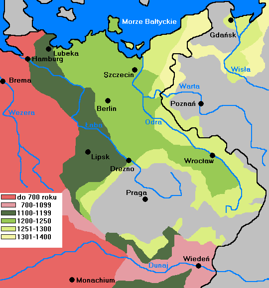
The medieval contact zone between Germans and Slavs in Central Europe.

|
This historical map image could be re-created using vector graphics as an SVG file. This has several advantages; see Commons:Media for cleanup for more information. If an SVG form of this image is available, please upload it and afterwards replace this template with
{{vector version available|new image name}}.
It is recommended to name the SVG file “Osadnictwo niemieckie na wschodzie.svg”—then the template Vector version available (or Vva) does not need the new image name parameter. |
Summary[edit]
| Description |
English: German settlement in Poland and Czechia and Elbe region |
||
| Date | |||
| Source | Own work, based on Walter Kuhn: | ||
| Author | Mix321 | ||
| Permission (Reusing this file) |
I, the copyright holder of this work, hereby publish it under the following license:
|

File history
Click on a date/time to view the file as it appeared at that time.
| Date/Time | Thumbnail | Dimensions | User | Comment | |
|---|---|---|---|---|---|
| current | 16:10, 10 July 2010 | | 540 × 579 (32 KB) | Mix321 (talk | contribs) | {{Information |Description={{en|1=German settelment in Poland and Czech and Elbe region}} |Source={{own}} |Author=Mix321 |Date=2010.VII.10 |Permission={{GFDL-self}} |other_versions= }} source: http://www.info-poland.buffalo.edu/classroom/m |
You cannot overwrite this file.
File usage on Commons
There are no pages that use this file.
File usage on other wikis
The following other wikis use this file:
- Usage on ar.wikipedia.org
- Usage on bn.wikipedia.org
- Usage on ca.wikipedia.org
- Usage on csb.wikipedia.org
- Usage on cs.wikipedia.org
- Usage on de.wikipedia.org
- Usage on el.wikipedia.org
- Usage on en.wikipedia.org
- Usage on eo.wikipedia.org
- Usage on es.wikipedia.org
- Usage on eu.wikipedia.org
- Usage on fi.wikipedia.org
- Usage on fr.wikipedia.org
- Usage on he.wikipedia.org
- Usage on pl.wikipedia.org
- Usage on sl.wikipedia.org
- Usage on sr.wikipedia.org
- Usage on tl.wikipedia.org
- Usage on uk.wikipedia.org
- Usage on zh.wikipedia.org