File:Outer Hebrides UK relief location map.jpg
둘러보기로 이동
검색으로 이동

미리 보기 크기: 456 × 600 픽셀 다른 해상도: 182 × 240 픽셀 | 365 × 480 픽셀 | 584 × 768 픽셀 | 778 × 1,024 픽셀 | 2,001 × 2,632 픽셀
원본 파일 (2,001 × 2,632 픽셀, 파일 크기: 481 KB, MIME 종류: image/jpeg)
캡션
설명
이 파일이 나타내는 바에 대한 한 줄 설명을 추가합니다
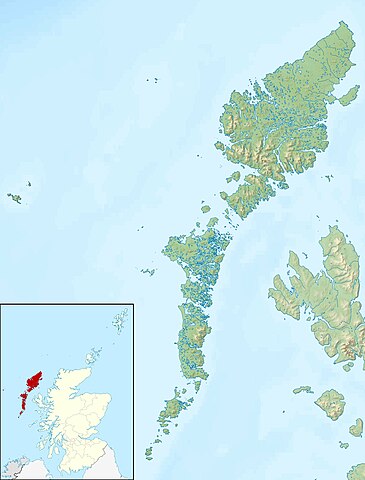
Relief map of the Outer Hebrides
| 설명 |
Relief map of the Outer Hebrides (excluding Sula Sgeir), UK. Equirectangular map projection on WGS 84 datum, with N/S stretched 180% Geographic limits:
|
| 날짜 | |
| 출처 |
|
| 저자 | Nilfanion, created using Ordnance Survey data |
| 저작권 (이 파일을 인용하기) |
이 파일은 크리에이티브 커먼즈 저작자표시-동일조건변경허락 3.0 Unported 라이선스로 배포됩니다. 저작자표시: Contains Ordnance Survey data © Crown copyright and database right
|
| 다른 버전 | File:Outer Hebrides UK blank map.svg - Blank map |
파일 역사
날짜/시간 링크를 클릭하면 해당 시간의 파일을 볼 수 있습니다.
| 날짜/시간 | 섬네일 | 크기 | 사용자 | 설명 | |
|---|---|---|---|---|---|
| 현재 | 2011년 11월 30일 (수) 12:26 | | 2,001 × 2,632 (481 KB) | Nilfanion (토론 | 기여) | {{Information |Description=Relief map of the Outer Hebrides (excluding Sula Sgeir), UK. Equirectangular map projection on WGS 84 datum, with N/S stretched 180% Geographic limits: *West: 8.70W *East: 6.10W *North: 58 |
이 파일을 덮어쓸 수 없습니다.
이 파일을 사용하는 문서
다음 문서 2개가 이 파일을 사용하고 있습니다:
이 파일을 사용하고 있는 모든 위키의 문서 목록
다음 위키에서 이 파일을 사용하고 있습니다:
- ar.wikipedia.org에서 이 파일을 사용하고 있는 문서 목록
- bg.wikipedia.org에서 이 파일을 사용하고 있는 문서 목록
- ceb.wikipedia.org에서 이 파일을 사용하고 있는 문서 목록
- da.wikipedia.org에서 이 파일을 사용하고 있는 문서 목록
- de.wikipedia.org에서 이 파일을 사용하고 있는 문서 목록
- Soay (St. Kilda)
- Hirta
- Uist
- Boreray (St. Kilda)
- Uig (Lewis)
- Dùn
- North Rona
- Sula Sgeir
- Stac Lee
- Stac an Armin
- Barra Head (Schottland)
- Loch Druidibeag
- Lewis and Harris
- Seaforth Island
- Haskeir
- Vorlage:Positionskarte Schottland Outer Hebrides
- Stiaraval
- Ruaval
- Heaval
- Ben Tangaval
- Beinn Sciathan
- Eriskay-Sund
- Acairseid Mhor
- Berneray-Sund
- Loch Borve
- Loch Beag Bhuirgh
- Loch Bhrusda
- Borve Hill
- Beinn Shleibhe
- Loch Seaforth
- Loch Odhairn
- Scarp
- Fladday
- Sound of Scarp
- Loch Langavat
- Mealasta
- Little Bernera
- Flodaigh
- Flodaigh (Bernera)
- Bearasay
- Seanna Chnoc
- Kealasay
- Campay
- Craigeam
이 파일의 더 많은 사용 내역을 봅니다.