File:PIA02405.jpg

File originale (7 238 × 3 135 pixel, dimensione del file: 2,2 MB, tipo MIME: image/jpeg)
Didascalie
Didascalie
Dettagli
[modifica]
| Descrizione |
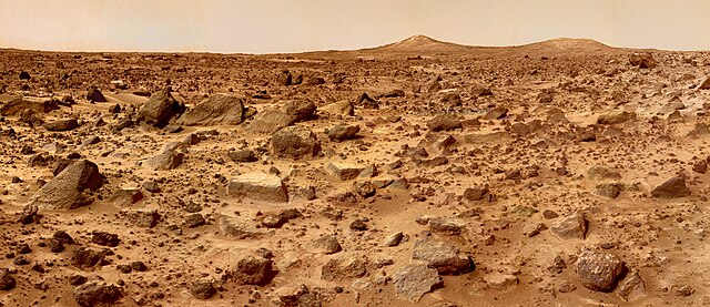
The Twin Peaks are modest-size hills to the southwest of the Mars Pathfinder landing site. They were discovered on the first panoramas taken by the IMP camera on the 4th of July, 1997, and subsequently identified in Viking Orbiter images taken over 20 years ago. The peaks are approximately 30-35 meters (-100 feet) tall. North Twin is approximately 860 meters (2800 feet) from the lander, and South Twin is about a kilometer away (3300 feet). The scene includes bouldery ridges and swales or "hummocks" of flood debris that range from a few tens of meters away from the lander to the distance of the South Twin Peak. The composite color frames that make up this "left-eye" image consist of 8 frames, taken with different color filters that were enlarged by 500% and then co-added using Adobe Photoshop to produce, in effect, a super-resolution panchromatic frame that is sharper than an individual frame would be. This panchromatic frame was then colorized with the red, green, and blue filtered images from the same sequence. The color balance was adjusted to approximate the true color of Mars. This image and File:PIA02406.jpg (right eye) make up a stereo pair. Mars Pathfinder is the second in NASA's Discovery program of low-cost spacecraft with highly focused science goals. The Jet Propulsion Laboratory, Pasadena, CA, developed and manages the Mars Pathfinder mission for NASA's Office of Space Science, Washington, D.C. JPL is a division of the California Institute of Technology (Caltech). The IMP was developed by the University of Arizona Lunar and Planetary Laboratory under contract to JPL. Peter Smith is the Principal Investigator. |
| Data | |
| Fonte | http://photojournal.jpl.nasa.gov/catalog/PIA02405 |
| Autore | NASA/JPL |
| Altre versioni |
 |
Questa immagine o filmato è stato catalogato dal Jet Propulsion Lab della National Aeronautics and Space Administration (NASA) degli Stati Uniti d'Americacon il Photo ID: PIA02405.Questo tag non indica lo status del copyright dell'opera ad esso associato. È quindi richiesto un normale tag di copyright. Vedi Commons:Licenze per maggiori informazioni. Altre lingue:
|
Licenza
[modifica]
| Questo file è nel pubblico dominio perché creato dalla NASA. La politica sul copyright della NASA afferma che «il materiale della NASA non è protetto da copyright a meno che non sia specificato altrimenti». (NASA copyright policy e JPL Image Use Policy). | ||
 |
Attenzione:
|
Cronologia del file
Fare clic su un gruppo data/ora per vedere il file come si presentava nel momento indicato.
| Data/Ora | Miniatura | Dimensioni | Utente | Commento | |
|---|---|---|---|---|---|
| attuale | 16:42, 25 mag 2007 | | 7 238 × 3 135 (2,2 MB) | Clh288~commonswiki (discussione | contributi) | {{Information |Description= The Twin Peaks are modest-size hills to the southwest of the Mars Pathfinder landing site. They were discovered on the first panoramas taken by the IMP camera on the 4th of July, 1997, and subsequently identified in Viking O |
Impossibile sovrascrivere questo file.
Utilizzo del file
Le seguenti 2 pagine usano questo file:
Utilizzo globale del file
Anche i seguenti wiki usano questo file:
- Usato nelle seguenti pagine di ar.wikipedia.org:
- Usato nelle seguenti pagine di ast.wikipedia.org:
- Usato nelle seguenti pagine di bg.wikipedia.org:
- Usato nelle seguenti pagine di ca.wikipedia.org:
- Usato nelle seguenti pagine di ca.wikinews.org:
- Usato nelle seguenti pagine di cs.wikipedia.org:
- Usato nelle seguenti pagine di da.wikipedia.org:
- Usato nelle seguenti pagine di de.wikipedia.org:
- Usato nelle seguenti pagine di eml.wikipedia.org:
- Usato nelle seguenti pagine di en.wikipedia.org:
- Usato nelle seguenti pagine di en.wikivoyage.org:
- Usato nelle seguenti pagine di eo.wikipedia.org:
- Usato nelle seguenti pagine di es.wikipedia.org:
- Usato nelle seguenti pagine di eu.wikipedia.org:
- Usato nelle seguenti pagine di fi.wikipedia.org:
- Usato nelle seguenti pagine di fr.wikipedia.org:
- Usato nelle seguenti pagine di fr.wikinews.org:
- Usato nelle seguenti pagine di gl.wikipedia.org:
- Usato nelle seguenti pagine di hi.wikipedia.org:
- Usato nelle seguenti pagine di hu.wikipedia.org:
- Usato nelle seguenti pagine di id.wikipedia.org:
- Usato nelle seguenti pagine di it.wikipedia.org:
- Usato nelle seguenti pagine di kbp.wikipedia.org:
- Usato nelle seguenti pagine di kw.wikipedia.org:
- Usato nelle seguenti pagine di lt.wikipedia.org:
- Usato nelle seguenti pagine di mr.wikipedia.org:
- Usato nelle seguenti pagine di mwl.wikipedia.org:
- Usato nelle seguenti pagine di nl.wikipedia.org:
Visualizza l'utilizzo globale di questo file.