File:Peloponnese Middle Ages map-en.svg
Jump to navigation
Jump to search

Size of this PNG preview of this SVG file: 766 × 600 pixels. Other resolutions: 307 × 240 pixels | 613 × 480 pixels | 981 × 768 pixels | 1,280 × 1,002 pixels | 2,560 × 2,005 pixels | 1,785 × 1,398 pixels.
Original file (SVG file, nominally 1,785 × 1,398 pixels, file size: 2.04 MB)
Captions
Captions
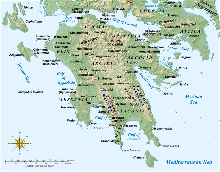
Map of the medieval Peloponnese with its principal localities
| Description |
English: Map of Peloponnese, Greece, with the sites of major importance during the Middle Ages.
Français : Carte du Péloponnèse, Grèce, avec principaux sites du Moyen Âge. UTM projection; WGS84 datum |
| Date | (UTC) |
| Source | |
| Author |
|
| Other versions |
|


| This is a retouched picture, which means that it has been digitally altered from its original version. Modifications: English version, added more sites. The original can be viewed here: Peloponnese Middle Ages map-fr.svg:
|
I, the copyright holder of this work, hereby publish it under the following licenses:
This file is licensed under the Creative Commons Attribution-Share Alike 3.0 Unported, 2.5 Generic, 2.0 Generic and 1.0 Generic license.
- You are free:
- to share – to copy, distribute and transmit the work
- to remix – to adapt the work
- Under the following conditions:
- attribution – You must give appropriate credit, provide a link to the license, and indicate if changes were made. You may do so in any reasonable manner, but not in any way that suggests the licensor endorses you or your use.
- share alike – If you remix, transform, or build upon the material, you must distribute your contributions under the same or compatible license as the original.

|
Permission is granted to copy, distribute and/or modify this document under the terms of the GNU Free Documentation License, Version 1.2 or any later version published by the Free Software Foundation; with no Invariant Sections, no Front-Cover Texts, and no Back-Cover Texts. A copy of the license is included in the section entitled GNU Free Documentation License. |
You may select the license of your choice.
Original upload log[edit]
This image is a derivative work of the following images:
- File:Peloponnese_Middle_Ages_map-fr.svg licensed with Cc-by-sa-3.0,2.5,2.0,1.0, GFDL
- 2008-04-07T20:18:41Z Sting 1785x1398 (1175068 Bytes) Bigger labels
- 2008-04-04T20:27:23Z Sting 1785x1398 (1175530 Bytes) {{Information |Description={{en|Map of [[:en:Peloponnese|Peloponnese]], Greece, with major places of the Middle Ages.}} {{fr|Carte du [[:fr:Péloponnèse|Péloponnèse]], Grèce, avec principaux sites du Moyen Âge.}} |Source
Uploaded with derivativeFX
File history
Click on a date/time to view the file as it appeared at that time.
| Date/Time | Thumbnail | Dimensions | User | Comment | |
|---|---|---|---|---|---|
| current | 11:02, 24 February 2014 | | 1,785 × 1,398 (2.04 MB) | Cplakidas (talk | contribs) | various minor tweaks, added approx. location of Grand Magne text to paths |
| 13:35, 17 August 2012 |  | 1,785 × 1,398 (1.16 MB) | Phso2 (talk | contribs) | Minor changes : typos, anticised modern names in brackets, duplicate Pylos/Navarin | |
| 17:13, 10 May 2010 |  | 1,785 × 1,398 (1.16 MB) | Cplakidas (talk | contribs) | various tweaks with names, added the Hexamilion wall | |
| 10:36, 21 April 2010 |  | 1,785 × 1,398 (1.16 MB) | Cplakidas (talk | contribs) | bolded city names to make them more discernible | |
| 10:21, 21 April 2010 |  | 1,785 × 1,398 (1.15 MB) | Cplakidas (talk | contribs) | {{Information |Description={{en|Map of Peloponnese, Greece, with the sites of major importance during the Middle Ages.}} {{fr|Carte du Péloponnèse, Grèce, avec principaux sites du Moyen Âge.}}<br/> UTM proje |
You cannot overwrite this file.
File usage on Commons
The following page uses this file:
File usage on other wikis
The following other wikis use this file:
- Usage on azb.wikipedia.org
- Usage on ca.wikipedia.org
- Usage on cs.wikipedia.org
- Usage on de.wikipedia.org
- Usage on el.wikipedia.org
- Usage on en.wikipedia.org
- Constantine XI Palaiologos
- Principality of Achaea
- Morea
- Lordship of Argos and Nauplia
- Las (Greece)
- Battle of the Olive Grove of Kountouras
- William of Champlitte
- Geoffrey I of Villehardouin
- Skorta
- Nerio I Acciaioli
- Chlemoutsi
- Glarentza
- Ottoman–Venetian War (1463–1479)
- Morea revolt of 1453–1454
- Leo Sgouros
- Ezeritai
- Melingoi
- Battle of Prinitza
- Battle of Makryplagi
- User:Cplakidas/Articles
- Battle of the Echinades (1427)
- Barony of Vostitsa
- Barony of Patras
- Barony of Akova
- Barony of Passavant
- Barony of Geraki
View more global usage of this file.