File:Ph physical map.png
קפיצה לניווט
קפיצה לחיפוש
גודל התצוגה המקדימה הזאת: 382 × 598 פיקסלים. רזולוציות אחרות: 153 × 240 פיקסלים | 600 × 940 פיקסלים.
לקובץ המקורי (600 × 940 פיקסלים, גודל הקובץ: 114 ק"ב, סוג MIME: image/png)
כיתובים
כיתובים
נא להוסיף משפט שמסביר מה הקובץ מייצג
תקציר[עריכה]
| תיאור |
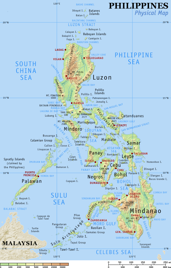
English: Physical map of the Philippines, showing all the major and some minor islands, bodies of water, mountains, and some major cities. |
| תאריך יצירה | |
| מקור | נוצר על־ידי מעלה היצירה |
| יוצר | Eugene Alvin Villar (seav) |
| גרסאות אחרות |
|


|

|
יש ליצור מחדש את התמונה map הזו באמצעות גרפיקה וקטורית כדוגמת קובץ SVG. לפעולה זו מספר יתרונות, כפי שניתן לקרוא (באנגלית) בדף Commons:Media for cleanup. אם ברשותכם קובץ SVG, אנא העלו אותו. לאחר מכן, החליפו תבנית זו בתבנית
{{vector version available|שם הקובץ.svg}} |
רישיון[עריכה]
אני, בעל זכויות היוצרים על היצירה הזאת, מפרסם אותה בזאת תחת הרישיונות הבאים:
הקובץ הזה מתפרסם לפי תנאי רישיון קריאייטיב קומונז ייחוס-שיתוף זהה 4.0 בין־לאומי.
- הנכם רשאים:
- לשתף – להעתיק, להפיץ ולהעביר את העבודה
- לערבב בין עבודות – להתאים את העבודה
- תחת התנאים הבאים:
- ייחוס – יש לתת ייחוס הולם, לתת קישור לרישיון, ולציין אם נעשו שינויים. אפשר לעשות את זה בכל צורה סבירה, אבל לא בשום צורה שמשתמע ממנה שמעניק הרישיון תומך בך או בשימוש שלך.
- שיתוף זהה – אם תיצרו רמיקס, תשנו, או תבנו על החומר, חובה עליכם להפיץ את התרומות שלך לפי תנאי רישיון זהה או תואם למקור.
הקובץ הזה מתפרסם לפי תנאי רישיון קריאייטיב קומונז ייחוס-שיתוף זהה 3.0 לא מותאם.
- הנכם רשאים:
- לשתף – להעתיק, להפיץ ולהעביר את העבודה
- לערבב בין עבודות – להתאים את העבודה
- תחת התנאים הבאים:
- ייחוס – יש לתת ייחוס הולם, לתת קישור לרישיון, ולציין אם נעשו שינויים. אפשר לעשות את זה בכל צורה סבירה, אבל לא בשום צורה שמשתמע ממנה שמעניק הרישיון תומך בך או בשימוש שלך.
- שיתוף זהה – אם תיצרו רמיקס, תשנו, או תבנו על החומר, חובה עליכם להפיץ את התרומות שלך לפי תנאי רישיון זהה או תואם למקור.

|
מוענקת בכך הרשות להעתיק, להפיץ או לשנות את המסמך הזה, לפי תנאי הרישיון לשימוש חופשי במסמכים של גנו, גרסה 1.2 או כל גרסה מאוחרת יותר שתפורסם על־ידי המוסד לתוכנה חופשית; ללא פרקים קבועים, ללא טקסט עטיפה קדמית וללא טקסט עטיפה אחורית. עותק של הרישיון כלול בפרק שכותרתו הרישיון לשימוש חופשי במסמכים של גנו. |
הנכם מוזמנים לבחור את הרישיון הרצוי בעיניכם.
יומן העלאה מקורי[עריכה]
תיאור הקובץ המקורי נמצא כאן. כל שמות המשתמשים הבאים מתייחסים ל-en.wikipedia.
| Date | User | File size | History log |
|---|---|---|---|
| 2005-08-29 15:09 | Riumplus | (117068 bytes) | Removed unused colours in the PNG palette, losslessly shrinking file size by 4% |
| 2004-07-25 09:09 | Guanaco | (121976 bytes) | optimize |
| 2003-08-17 08:46 | Seav | (122906 bytes) | Updated map with more details |
| 2003-06-20 11:13 | Seav | (130670 bytes) | Physical map of the Philippines. |
היסטוריית הקובץ
ניתן ללחוץ על תאריך/שעה כדי לראות את הקובץ כפי שנראה באותו זמן.
| תאריך/שעה | תמונה ממוזערת | ממדים | משתמש | הערה | |
|---|---|---|---|---|---|
| נוכחית | 22:05, 1 במרץ 2007 | | 940 × 600 (114 ק"ב) | Tene~commonswiki (שיחה | תרומות) | Optimised (0) |
| 17:21, 16 בספטמבר 2005 |  | 940 × 600 (114 ק"ב) | Saperaud~commonswiki (שיחה | תרומות) | Physical map of the Philippines, showing all the major and some minor islands, bodies of water, mountains, and some major cities. See blank version which can be used for other language |
אין באפשרותך לדרוס את הקובץ הזה.
שימוש בקובץ
הדפים הבאים משתמשים בקובץ הזה:
שימוש גלובלי בקובץ
אתרי הוויקי השונים הבאים משתמשים בקובץ זה:
- שימוש באתר af.wikipedia.org
- שימוש באתר an.wikipedia.org
- שימוש באתר ba.wikipedia.org
- שימוש באתר bg.wikipedia.org
- שימוש באתר bn.wikipedia.org
- שימוש באתר br.wikipedia.org
- שימוש באתר ca.wikipedia.org
- שימוש באתר cbk-zam.wikipedia.org
- שימוש באתר ceb.wikipedia.org
- שימוש באתר da.wikipedia.org
- שימוש באתר de.wikipedia.org
- שימוש באתר en.wikipedia.org
- User:Seav
- List of islands of the Philippines
- Template:Pic of the day/Archive1
- Ecoregions in the Philippines
- Wikipedia:Picture of the day/June 2004
- Manila Trench
- Wikipedia:Picture of the day/April 2005
- Wikipedia:POTD/April 13, 2005
- Wikipedia:Picture of the day/April 13, 2005
- User:Cyde/Featured pictures
- Wikipedia:Featured picture candidates/delist/2006
- Portal:Maps/Selected picture
- User talk:Howard the Duck/Archive3
- Wikipedia:Featured picture candidates/delist/2007
- Island groups of the Philippines
- Wikipedia:Featured picture candidates/delist/Ph physical map.png
- List of potentially active volcanoes in the Philippines
- User:Wittylama/FP Deletion
- Extreme points of the Philippines
- Portal:Maps/Selected picture/1
- Outline of the Philippines
- List of ultras of the Philippines
- List of active volcanoes in the Philippines
- List of inactive volcanoes in the Philippines
- Philippine Mobile Belt
- List of rivers of the Philippines
- Benham Rise
- Philippine Fault System
- List of lighthouses in the Philippines
- Wikipedia:Featured picture candidates/delist/2010
- Marikina Valley Fault System
- Wikipedia:Featured picture candidates/delist/File:Ph physical map.png
- List of mountains in the Philippines
- List of lakes of the Philippines
- List of protected areas of the Philippines
- List of bays of the Philippines
- List of headlands of the Philippines
צפייה בשימושים גלובליים נוספים של קובץ זה.