File:Prusy historyczne.png
Jump to navigation
Jump to search
No higher resolution available.
Prusy_historyczne.png (613 × 459 pixels, file size: 51 KB, MIME type: image/png)
Captions
Captions
Add a one-line explanation of what this file represents
Summary[edit]
| Description |
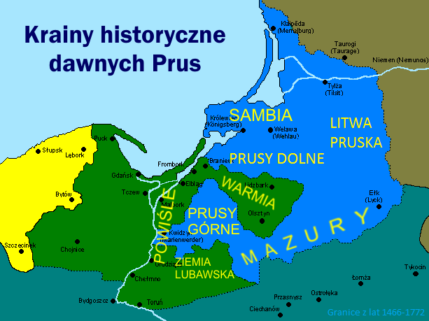
English: Map of historical lands and regions in Prussia: Warmia (Ermland), Mazury (Mazuria), Prusy Górne (Oberland), Prusy Dolne, Powiśle, Lubawa region, Sambia, Litwa Pruska (Lithuania Minor).
Polski: Mapa krain i regionów historycznych na terenie dawnych Prus, na tle granic podziału Prus w latach 1466-1772: Warmia, Mazury, Prusy Górne, Prusy Dolne, Powiśle, Ziemia Lubawska, Sambia, Litwa Pruska |
||
| Date | 07.09.2008 | ||
| Source | Own work, na podstawie: Marian Biskup "Szkice z dziejów Pomorza", t. 1, Warszawa 1958 oraz M. Biskup, G. Labuda "Dzieje Zakonu Krzyżackiego w Prusach", Gdańsk 1986 (mapa na str. 439) | ||
| Author | Popik | ||
| Permission (Reusing this file) |
|
File history
Click on a date/time to view the file as it appeared at that time.
| Date/Time | Thumbnail | Dimensions | User | Comment | |
|---|---|---|---|---|---|
| current | 18:26, 30 November 2016 | | 613 × 459 (51 KB) | Popik (talk | contribs) | Reverted to version as of 14:54, 30 November 2016 (UTC) |
| 16:20, 30 November 2016 |  | 613 × 459 (52 KB) | Popik (talk | contribs) | Reverted to version as of 14:44, 30 November 2016 (UTC) | |
| 14:54, 30 November 2016 |  | 613 × 459 (51 KB) | Popik (talk | contribs) | Poprawiona wersja z Litwą Pruską (Mniejszą) | |
| 14:44, 30 November 2016 |  | 613 × 459 (52 KB) | Popik (talk | contribs) | Uzupełnienie o Litwę Pruską (Litwę Mniejszą), której zabrakło w poprzednich wersjach. | |
| 17:21, 3 August 2014 |  | 613 × 459 (62 KB) | Popik (talk | contribs) | Uzupełnienie o Prusy Dolne, których zabrakło w poprzedniej wersji | |
| 09:51, 7 September 2008 |  | 613 × 459 (87 KB) | Popik (talk | contribs) | {{Information |Description={{en|1=Map of historical lands and regions in Prussia: Warmia, Mazury, Prusy Górne, Powiśle, Lubawa region, Sambia.}} {{pl|1=Mapa krain i regionów historycznych na terenie dawnych Prus, na tle granic podziału Prus w latach 1 |
You cannot overwrite this file.
File usage on Commons
The following 2 pages use this file:
File usage on other wikis
The following other wikis use this file:
- Usage on be.wikipedia.org
- Usage on cs.wikipedia.org
- Usage on da.wikipedia.org
- Usage on de.wikipedia.org
- Usage on en.wikipedia.org
- Usage on eo.wikipedia.org
- Usage on es.wikipedia.org
- Usage on eu.wikipedia.org
- Usage on gl.wikipedia.org
- Usage on ja.wikipedia.org
- Usage on ka.wikipedia.org
- Usage on pl.wikipedia.org
- Usage on pl.wikiquote.org
- Usage on sl.wikipedia.org
- Usage on uk.wikipedia.org
- Usage on www.wikidata.org
- Usage on zh.wikipedia.org