File:Pyrenees topographic map-en.svg
Jump to navigation
Jump to search

ഈ SVG പ്രമാണത്തിന്റെ PNG പ്രിവ്യൂവിന്റെ വലിപ്പം: 800 × 475 പിക്സലുകൾ. മറ്റ് റെസലൂഷനുകൾ: 320 × 190 പിക്സലുകൾ | 640 × 380 പിക്സലുകൾ | 1,024 × 608 പിക്സലുകൾ | 1,280 × 760 പിക്സലുകൾ | 2,560 × 1,520 പിക്സലുകൾ | 3,200 × 1,900 പിക്സലുകൾ.
പൂർണ്ണ വലിപ്പം (എസ്.വി.ജി. പ്രമാണം, നാമമാത്രമായ 3,200 × 1,900 പിക്സലുകൾ, പ്രമാണത്തിന്റെ വലിപ്പം: 6.3 എം.ബി.)
തലവാചകം
തലവാചകങ്ങൾ
ഈ പ്രമാണം എന്തിനെ പ്രതിനിധീകരിക്കുന്നുവെന്ന ഒറ്റവരി വിശദീകരണം ചേർക്കുക
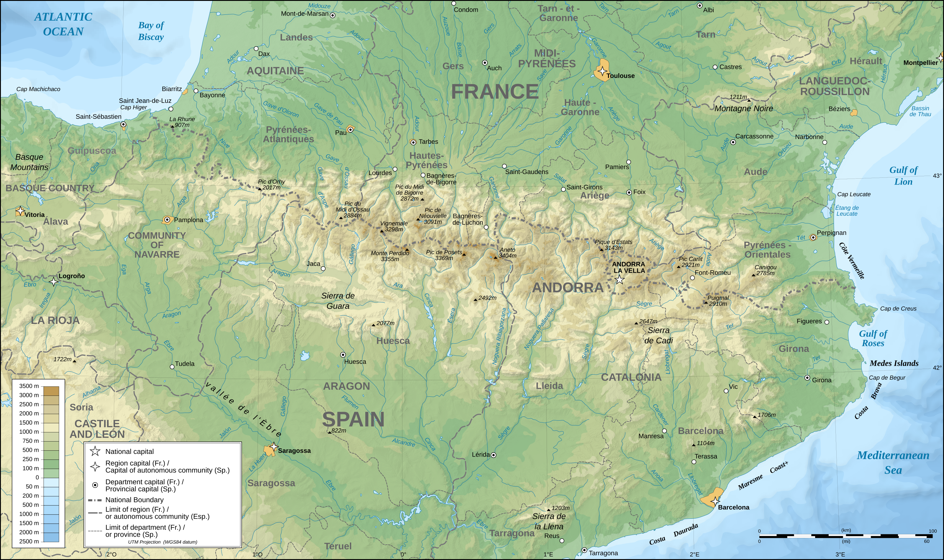
Topographic map of the Pyrenees Mountains
| വിവരണം |
English: Topographic map in English of the Pyrenees Mountains. Note: The shaded relief is a raster image embedded in the SVG file. Français : Carte topographique des Pyrénées en english.
UTM projection; WGS84 datum; shaded relief (composite image of N-W, W and N lightning positions);Note : Le relief ombré est une image bitmap embarquée dans le fichier SVG. *The approximate horizontal accuracy of topographic data and shore/lakes limits is 1,125 m (per pixel). This map should not be printed over a 1:1 ratio (27.09 x 16.09cm), which corresponds to a scale of 1:2,010,221. *Approximate scale of the bathymetry: 1:7,708,000 (precision: 1,927 m) |
| തീയതി | (UTC) |
| സ്രോതസ്സ് | |
| സ്രഷ്ടാവ് |
|
| ഇത് ഒരു മിനുക്കിയെടുത്ത ചിത്രമാണ്, യഥാർത്ഥ പതിപ്പിൽ നിന്ന് ഡിജിറ്റലായി മാറ്റങ്ങൾ വരുത്തിയിട്ടുണ്ടെന്നാണ് ഇതിനർത്ഥം. മാറ്റങ്ങൾ: translation into English. യഥാർത്ഥ പതിപ്പ് ഇവിടെ കാണാം: Pyrenees topographic map-fr.svg. മാറ്റങ്ങൾ വരുത്തിയത് RedWolf.
|
ഈ സൃഷ്ടിയുടെ പകർപ്പവകാശ ഉടമയായ ഞാൻ, താഴെ പറയുന്ന അനുമതികളിൽ ഈ സൃഷ്ടി ഇതിനാൽ പ്രസിദ്ധീകരിക്കുന്നു:
ഈ പ്രമാണത്തിന് അനുമതി നൽകപ്പെട്ടിരിക്കുന്നത് ക്രിയേറ്റീവ് കോമൺസ് ആട്രിബ്യൂഷൻ-ഷെയർ എലൈക് 2.5 സാമാന്യ, 2.0 സാമാന്യ ഒപ്പം 1.0 സാമാന്യ അനുവാദപത്രങ്ങൾ പ്രകാരമാണ്.
- താങ്കൾക്കുള്ള സ്വാതന്ത്ര്യങ്ങൾ:
- പങ്ക് വെയ്ക്കൽ – കൃതി പകർത്താനും, വിതരണം ചെയ്യാനും, പ്രസരിപ്പിക്കാനും
- പുനഃമിശ്രണം ചെയ്യൽ – കൃതി അനുയുക്തമാക്കാൻ
- താഴെ പറയുന്ന ഉപാധികൾ പാലിക്കുക:
- കടപ്പാട് – രചയിതാവോ അനുമതിയുള്ളയാളോ വ്യക്തമാക്കിയിട്ടുള്ള വിധത്തിൽ കൃതിയ്ക്കുള്ള കടപ്പാട് താങ്കൾ നൽകിയിരിക്കണം. താങ്കൾക്കിത് ഏത് വിധത്തിൽ വേണമെങ്കിലും ചെയ്യാവുന്നതാണ്, പക്ഷേ അത് അവർ താങ്കളേയോ താങ്കളുടെ ഉപയോഗത്തേയോ അടിച്ചേൽപ്പിച്ചതു പോലെയാവരുത്.
- ഇതു പോലെ പങ്ക് വെയ്ക്കുക – ഈ സൃഷ്ടിയെ പുനഃമിശ്രണം ചെയ്തോ രൂപാന്തരപ്പെടുത്തിയോ അടിസ്ഥാനപ്പെടുത്തിയോ ഉണ്ടാക്കുന്നവ; താങ്കളുടെ സംഭാവനയടക്കമുള്ള സൃഷ്ടി യഥാർത്ഥ സൃഷ്ടിയുടെ അതേ അല്ലെങ്കിൽ അനുരൂപമായ ഉപയോഗാനുമതിയിൽ മാത്രമേ താങ്കൾ വിതരണം ചെയ്യാവൂ.
| ഈ പ്രമാണത്തിന് അനുമതി നൽകപ്പെട്ടിരിക്കുന്നത് ക്രിയേറ്റീവ് കോമൺസ് ആട്രിബ്യൂഷൻ-ഷെയർ എലൈക് 3.0 അൺപോർട്ടഡ് അനുവാദപത്ര പ്രകാരമാണ്. | ||
| ||
| ജി.എഫ്.ഡി.എൽ. അനുവാദപത്രത്തിന്റെ അനുമതി പുതുക്കലിന്റെ ഭാഗമായാണ് ഈ ടാഗ് ചേർക്കപ്പെട്ടിരിക്കുന്നത്. |

|
സ്വതന്ത്ര സോഫ്റ്റ്വേർ സമിതി പ്രസിദ്ധീകരിച്ചിട്ടുള്ള ഗ്നു സ്വതന്ത്ര പ്രമാണ അനുവാദപത്രം പതിപ്പ് 1.2 അല്ലെങ്കിൽ പുതിയ പതിപ്പുകൾ പ്രകാരം; മാറ്റമില്ലാത്ത ഭാഗങ്ങളില്ലാതെ, മുൻചട്ടയിലെ എഴുത്തുകൾ ഇല്ലാതെ, പിൻചട്ടയിലെ എഴുത്തുകൾ ഇല്ലാതെ പകർത്താനും, വിതരണം ചെയ്യാനും ഒപ്പം/അല്ലെങ്കിൽ ഈ പ്രമാണത്തിൽ മാറ്റം വരുത്തുവാനും ഉള്ള അവകാശങ്ങൾ നൽകുന്നു. ഗ്നു സ്വതന്ത്ര പ്രമാണ അനുവാദപത്രം എന്ന തലക്കെട്ടിൽ അനുവാദപത്രത്തിന്റെ ഒരു പകർപ്പ് ഉൾപ്പെടുത്തിയിട്ടുണ്ട്. |
താങ്കൾക്ക് താങ്കളുടെ ഇച്ഛാനുസരണം അനുമതി തിരഞ്ഞെടുക്കാം.
യഥാർത്ഥ അപ്ലോഡ് രേഖ[തിരുത്തുക]
This image is a derivative work of the following images:
- File:Pyrenees_topographic_map-fr.svg licensed with Cc-by-sa-2.5,2.0,1.0, Cc-by-sa-3.0-migrated, GFDL
- 2008-09-23T15:49:03Z Sting 3200x1900 (6608359 Bytes) Using ETOPO1 data for bathymetry; new standard colors
- 2007-07-02T00:25:17Z Sting 3200x1900 (6191391 Bytes) + projection info in key ; + major cities areas ; some corrections in the rivers
- 2007-06-25T20:30:25Z Sting 3200x1900 (6166321 Bytes) + key for borders
- 2007-05-31T21:18:03Z Sting 3200x1900 (6163256 Bytes) Some corrections
- 2007-05-30T18:23:51Z Sting 3200x1900 (6163275 Bytes) {{Information |Description=Topographic map in French of the [[:en:Pyrenees|Pyrenees mountains]] |Source=Own work ;Topographic map : [http://www2.jpl.nasa.gov/srtm NASA Shuttle Radar Topography Mission] (SRTM3 v.2) (public dom
പ്രമാണ നാൾവഴി
ഏതെങ്കിലും തീയതി/സമയ കണ്ണിയിൽ ഞെക്കിയാൽ പ്രസ്തുതസമയത്ത് ഈ പ്രമാണം എങ്ങനെയായിരുന്നു എന്നു കാണാം.
| തീയതി/സമയം | ലഘുചിത്രം | അളവുകൾ | ഉപയോക്താവ് | അഭിപ്രായം | |
|---|---|---|---|---|---|
| നിലവിലുള്ളത് | 00:25, 28 മേയ് 2011 | | 3,200 × 1,900 (6.3 എം.ബി.) | RedWolf (സംവാദം | സംഭാവനകൾ) | {{Information |Description={{en|Topographic map in English of the Pyrenees mountains.<br/>''Note:'' The shaded relief is a raster image embedded in the SVG file.}} {{fr|Carte topographique des Pyrénées en english.<br/ |
ഈ പ്രമാണത്തിനു മുകളിൽ മറ്റൊരു പ്രമാണം ചേർക്കാൻ താങ്കൾക്ക് കഴിയില്ല.
പ്രമാണത്തിന്റെ ഉപയോഗം
താഴെ കാണുന്ന 12 താളുകളിൽ ഈ ചിത്രം ഉപയോഗിക്കുന്നു:
- File:Pyrenees map shaded relief-fr.svg
- File:Pyrenees relief map with rivers-fr.svg
- File:Pyrenees topo map-blank.jpg
- File:Pyrenees topographic map-ca.svg
- File:Pyrenees topographic map-de.svg
- File:Pyrenees topographic map-eo.svg
- File:Pyrenees topographic map-es.svg
- File:Pyrenees topographic map-fr.svg
- File:Pyrenees topographic map-mk.svg
- File:Pyrenees topographic map-pl.svg
- File:Pyrenees topographic map-ru.svg
- Template:Other versions/Pyrenees topographic map
പ്രമാണത്തിന്റെ ആഗോള ഉപയോഗം
താഴെ കൊടുത്തിരിക്കുന്ന മറ്റ് വിക്കികൾ ഈ പ്രമാണം ഉപയോഗിക്കുന്നു:
- am.wikipedia.org സംരംഭത്തിലെ ഉപയോഗം
- ar.wikipedia.org സംരംഭത്തിലെ ഉപയോഗം
- bg.wikipedia.org സംരംഭത്തിലെ ഉപയോഗം
- bh.wikipedia.org സംരംഭത്തിലെ ഉപയോഗം
- bn.wikipedia.org സംരംഭത്തിലെ ഉപയോഗം
- ca.wikipedia.org സംരംഭത്തിലെ ഉപയോഗം
- ceb.wikipedia.org സംരംഭത്തിലെ ഉപയോഗം
- cs.wikipedia.org സംരംഭത്തിലെ ഉപയോഗം
- da.wikipedia.org സംരംഭത്തിലെ ഉപയോഗം
- en.wikipedia.org സംരംഭത്തിലെ ഉപയോഗം
- Pyrenees
- Col du Tourmalet
- Canigou
- Aneto
- Pic du Midi de Bigorre
- Pre-Pyrenees
- Vignemale
- Monte Perdido
- Pic du Midi d'Ossau
- Montsec Range
- Larrun
- Pica d'Estats
- Col d'Aubisque
- Mallos de Riglos
- Collarada
- Pla d'Adet
- Mount Baigura
- Balaïtous
- Col d'Ares
- Col d'Aspin
- Pic Long
- Corbières Massif
- Hautza
- La Mongie
- Pic del Port Vell
- Pic de Sanfonts
- Port de Pailhères
- Port de Balès
- Col de Portet d'Aspet
- Col de Menté
- Col de Peyresourde
- Port de Larrau
- Col de Port
- Col de Marie-Blanque
- Puigmal
- Pic Ramougn
- Soum de Ramond
ഈ പ്രമാണത്തിന്റെ കൂടുതൽ ആഗോള ഉപയോഗം കാണുക.