File:Pyrenees topographic map-fr.svg
קפיצה לניווט
קפיצה לחיפוש

גודל התצוגה המקדימה הזאת מסוג PNG של קובץ ה־SVG הזה: 800 × 475 פיקסלים. רזולוציות אחרות: 320 × 190 פיקסלים | 640 × 380 פיקסלים | 1,024 × 608 פיקסלים | 1,280 × 760 פיקסלים | 2,560 × 1,520 פיקסלים | 3,200 × 1,900 פיקסלים.
לקובץ המקורי (קובץ SVG, הגודל המקורי: 3,200 × 1,900 פיקסלים, גודל הקובץ: 6.3 מ"ב)
כיתובים
כיתובים
נא להוסיף משפט שמסביר מה הקובץ מייצג
![]()
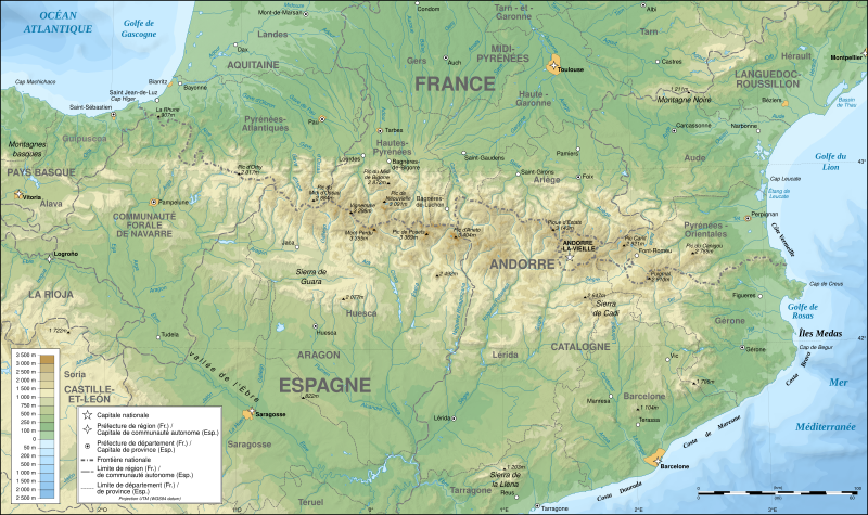
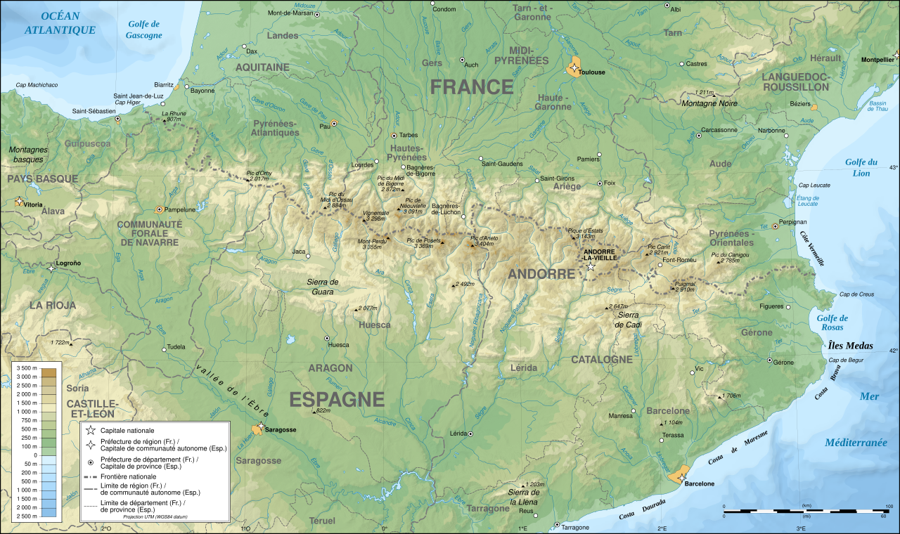
Detailed map of large dimension. For a better viewing, click on the link of the image above.
Carte détaillée de grande dimension. Pour une visualisation optimale, cliquer sur le lien de l'image ci-dessus.
תקציר[עריכה]
| תיאור |
English: Topographic map in French of the Pyrenees mountains.
Note: The shaded relief is a raster image embedded in the SVG file. Français : Carte topographique des Pyrénées en francais.
Note : Le relief ombré est une image bitmap embarquée dans le fichier SVG. Português: Mapa topográfico (em Francês) dos Pirenéus.
Español: Mapa topográfico (en francés) de los Pirineos.
UTM projection; WGS84 datum; shaded relief (composite image of N-W, W and N lightning positions);
|
||
| SVGהתפתחות | |||
| תאריך יצירה | May 2007 (modified September 2008) | ||
| מקור |
Own work;
|
||
| יוצר | |||
| אישורים והיתרים (שימוש חוזר בקובץ זה) |
|
||
| Georeferencing | If inappropriate please set warp_status = skip to hide. | ||
| גרסאות אחרות |
[]
|


הערכה[עריכה]
|

תמונה זו נבחרה כתמונת היום בתאריך 1 באוגוסט 2007. כותרתה: עברית: מפה טופוגרפית בצרפתית של הרי הפירינאים שפות אחרות:
Čeština: Francouzská mapa pohoří Pyreneje Dansk: Topografisk kort over Pyrenæerne på fransk. English: Topographic map in French of the Pyrenees mountains. Français : Carte topographique des Pyrénées en français. Magyar: A Pireneusok térképe Nederlands: Franse Topografische kaart van de Pyreneeën Português: Um mapa topográfico em francês, da região dos Pireneus. Română: Hartă topografică a munților Pirinei, Franța. Suomi: Topografinen kartta Ranskasta, Pyreneiden vuorilta. Svenska: Topografisk karta över Pyrenéerna på franska. Русский: Топографическая карта Пиренеев. Українська: Топографічна карта Піренеїв 中文: 法语注释的比利牛斯山地形图 中文(繁體): 庇里牛斯山的法語地形圖 עברית : מפה טופוגרפית בצרפתית של הרי הפירינאים |
רישיון[עריכה]
אני, בעל זכויות היוצרים על היצירה הזאת, מפרסם אותה בזאת תחת הרישיונות הבאים:

|
מוענקת בכך הרשות להעתיק, להפיץ או לשנות את המסמך הזה, לפי תנאי הרישיון לשימוש חופשי במסמכים של גנו, גרסה 1.2 או כל גרסה מאוחרת יותר שתפורסם על־ידי המוסד לתוכנה חופשית; ללא פרקים קבועים, ללא טקסט עטיפה קדמית וללא טקסט עטיפה אחורית. עותק של הרישיון כלול בפרק שכותרתו הרישיון לשימוש חופשי במסמכים של גנו. |
| הקובץ הזה מתפרסם לפי תנאי רישיון קריאייטיב קומונז ייחוס-שיתוף זהה 3.0 לא מותאם. | ||
| ||
| תבנית רישוי זו הוספה לקובץ כחלק מעדכון רישיון GFDL. |
- הנכם רשאים:
- לשתף – להעתיק, להפיץ ולהעביר את העבודה
- לערבב בין עבודות – להתאים את העבודה
- תחת התנאים הבאים:
- ייחוס – יש לתת ייחוס הולם, לתת קישור לרישיון, ולציין אם נעשו שינויים. אפשר לעשות את זה בכל צורה סבירה, אבל לא בשום צורה שמשתמע ממנה שמעניק הרישיון תומך בך או בשימוש שלך.
- שיתוף זהה – אם תיצרו רמיקס, תשנו, או תבנו על החומר, חובה עליכם להפיץ את התרומות שלך לפי תנאי רישיון זהה או תואם למקור.
הנכם מוזמנים לבחור את הרישיון הרצוי בעיניכם.
היסטוריית הקובץ
ניתן ללחוץ על תאריך/שעה כדי לראות את הקובץ כפי שנראה באותו זמן.
| תאריך/שעה | תמונה ממוזערת | ממדים | משתמש | הערה | |
|---|---|---|---|---|---|
| נוכחית | 00:05, 14 בדצמבר 2012 | | 1,900 × 3,200 (6.3 מ"ב) | Benh (שיחה | תרומות) | uses Helvetica over Arial when available. |
| 15:49, 23 בספטמבר 2008 |  | 1,900 × 3,200 (6.3 מ"ב) | Sting (שיחה | תרומות) | Using ETOPO1 data for bathymetry; new standard colors | |
| 00:25, 2 ביולי 2007 |  | 1,900 × 3,200 (5.9 מ"ב) | Sting (שיחה | תרומות) | + projection info in key ; + major cities areas ; some corrections in the rivers | |
| 20:30, 25 ביוני 2007 |  | 1,900 × 3,200 (5.88 מ"ב) | Sting (שיחה | תרומות) | + key for borders | |
| 21:18, 31 במאי 2007 |  | 1,900 × 3,200 (5.88 מ"ב) | Sting (שיחה | תרומות) | Some corrections | |
| 18:23, 30 במאי 2007 |  | 1,900 × 3,200 (5.88 מ"ב) | Sting (שיחה | תרומות) | {{Information |Description=Topographic map in French of the Pyrenees mountains |Source=Own work ;<br/>Topographic map : [http://www2.jpl.nasa.gov/srtm NASA Shuttle Radar Topography Mission] (SRTM3 v.2) (public domain) edited with [http:// |
אין באפשרותך לדרוס את הקובץ הזה.
שימוש בקובץ
הדפים הבאים משתמשים בקובץ הזה:
- Pyrenees
- User:Bryan/POTY2007-alt
- User:Giorgi Balakhadze/Gallery
- User:JoKalliauer/SVG test suites/Featured details
- User:Pfctdayelise/POTY07 categories/2007 list
- User:Pfctdayelise/POTY07 categories/Diagrams, coats of arms, art and illustrations
- User:Scratchinghead
- User:Sting/Gallery: Regional maps
- User talk:Ayack/Archives 1
- User talk:Sting/Archive 01
- Commons:Bistro/archives/juin 2007
- Commons:Featured picture candidates/File:Settlement map of the Greek tribes before the start of the Peloponnesian War-ru.png
- Commons:Featured picture candidates/Image:Pyrenees topographic map-fr.svg
- Commons:Featured picture candidates/Log/July 2007
- Commons:Featured picture candidates/Log/September 2022
- Commons:Featured pictures/Non-photographic media/Maps
- Commons:Featured pictures/chronological/2007-B
- Commons:Picture of the Year/2007/Galleries/All
- Commons:Picture of the Year/2007/Galleries/Graphic art and maps
- Commons:Picture of the Year/2007/Results/Round 1/Gallery
- Commons:Potd/2007-08 (de)
- Commons:Potd/2007-08 (eo)
- Commons:Potd/2007-08 (fr)
- Commons:Potd/2007-08 (nl)
- Commons:Potd/2007-08 (pl)
- Commons:Potd/2007-08 (pt)
- Commons:Potd/2007-08 (ro)
- Commons:Potd/2007-08 (ru)
- Commons:Potd/2007-08 (tr)
- Commons:Potd/2007-08 (uk)
- Commons:Potd/2007-08 (zh-hant)
- File:218 AC - Iter Gnaei Scipionis in Hispania.png
- File:49 AC - Iter Caesaris in Hispania.png
- File:Pyrenees map shaded relief-fr.svg
- File:Pyrenees relief map with rivers-fr.svg
- File:Pyrenees topo map-blank.jpg
- File:Pyrenees topographic map-ca.svg
- File:Pyrenees topographic map-de.svg
- File:Pyrenees topographic map-en.svg
- File:Pyrenees topographic map-eo.svg
- File:Pyrenees topographic map-es.svg
- File:Pyrenees topographic map-fr.svg
- File:Pyrenees topographic map-it.svg
- File:Pyrenees topographic map-mk.svg
- File:Pyrenees topographic map-pl.svg
- File:Pyrenees topographic map-ru.svg
- Template:Other versions/Pyrenees topographic map
- Template:Potd/2007-08
- Template:Potd/2007-08-01
- Template:Potd/2007-08-01 (ar)
- Template:Potd/2007-08-01 (ast)
- Template:Potd/2007-08-01 (be)
- Template:Potd/2007-08-01 (cs)
- Template:Potd/2007-08-01 (da)
- Template:Potd/2007-08-01 (de)
- Template:Potd/2007-08-01 (en)
- Template:Potd/2007-08-01 (es)
- Template:Potd/2007-08-01 (fi)
- Template:Potd/2007-08-01 (fr)
- Template:Potd/2007-08-01 (he)
- Template:Potd/2007-08-01 (hu)
- Template:Potd/2007-08-01 (is)
- Template:Potd/2007-08-01 (it)
- Template:Potd/2007-08-01 (ja)
- Template:Potd/2007-08-01 (ko)
- Template:Potd/2007-08-01 (nl)
- Template:Potd/2007-08-01 (pam)
- Template:Potd/2007-08-01 (pl)
- Template:Potd/2007-08-01 (pt)
- Template:Potd/2007-08-01 (ro)
- Template:Potd/2007-08-01 (ru)
- Template:Potd/2007-08-01 (sv)
- Template:Potd/2007-08-01 (uk)
- Template:Potd/2007-08-01 (zh-hans)
- Template:Potd/2007-08-01 (zh-hant)
- Template:Potd/2007-08 (zh-hans)
- Category:Borders of France-Spain
- Category:Pyrenees
שימוש גלובלי בקובץ
אתרי הוויקי השונים הבאים משתמשים בקובץ זה:
- שימוש באתר af.wikipedia.org
- שימוש באתר an.wikipedia.org
- שימוש באתר ar.wikipedia.org
- שימוש באתר azb.wikipedia.org
- שימוש באתר ba.wikipedia.org
- שימוש באתר bs.wikipedia.org
- שימוש באתר ca.wikipedia.org
- שימוש באתר cs.wikipedia.org
- שימוש באתר en.wikipedia.org
- שימוש באתר eo.wikipedia.org
- שימוש באתר es.wikipedia.org
- שימוש באתר et.wikipedia.org
- שימוש באתר eu.wikipedia.org
- שימוש באתר fa.wikipedia.org
- שימוש באתר fi.wikipedia.org
- שימוש באתר fr.wikipedia.org
- Ariège (département)
- Aude (département)
- Andorre
- Sentier de grande randonnée 10
- Haute-Garonne
- Hautes-Pyrénées
- Pyrénées-Orientales
- Pyrénées
- Liste des communes des Hautes-Pyrénées
- Discussion:Liste des communes des Hautes-Pyrénées
- Pau
- Béarn
- Bayonne
- Tarbes
- Adour
- Ariège (rivière)
- Vals (Ariège)
- Catalogne
- Aragon (communauté autonome)
- Huesca
- Bizanos
- Pays basque
- Discussion:Béarn
- Discussion:Pau
- Val d'Aran
- Prades (Pyrénées-Orientales)
- Haute-Navarre
- Lugdunum Convenarum
- Lourdes
צפייה בשימושים גלובליים נוספים של קובץ זה.