File:Rapid Transit Map of Delhi.jpg
Jump to navigation
Jump to search
Size of this preview: 800 × 576 pixels. Other resolutions: 320 × 230 pixels | 640 × 461 pixels | 1,024 × 738 pixels | 1,280 × 922 pixels | 2,560 × 1,844 pixels | 6,675 × 4,808 pixels.
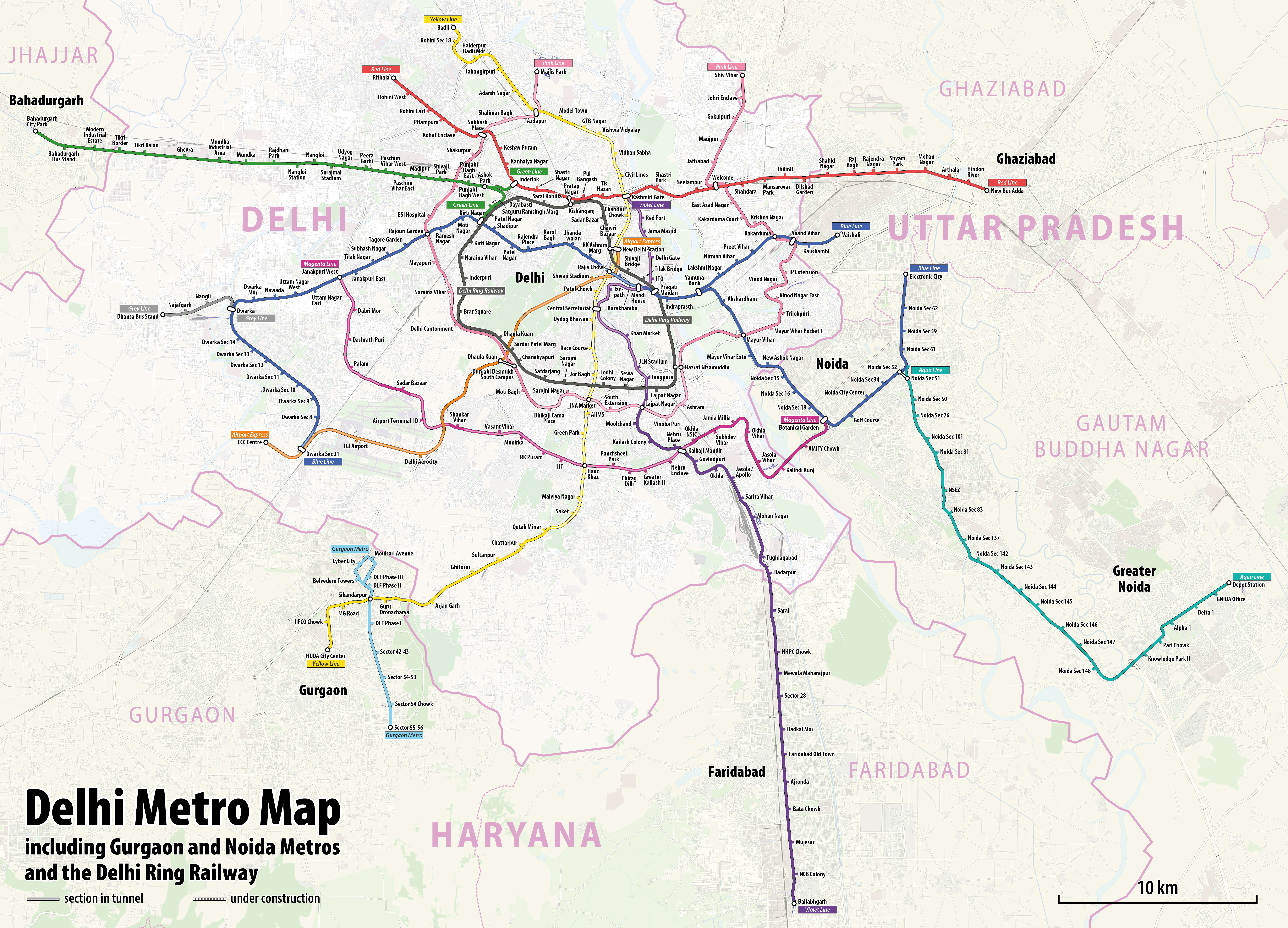
Original file (6,675 × 4,808 pixels, file size: 17.08 MB, MIME type: image/jpeg)
Captions
Captions
Add a one-line explanation of what this file represents
Summary[edit]
| Description |
|
| Date | see file history |
| Source | Own work using: OpenStreetMap data for the background |
| Author | Maximilian Dörrbecker (Chumwa) |
| Permission (Reusing this file) |
All OpenStreetMap data and maps are Creative Commons "CC-BY-SA 2.0" licensed This file is licensed under the Creative Commons Attribution-Share Alike 2.0 Generic license.
|
File history
Click on a date/time to view the file as it appeared at that time.
| Date/Time | Thumbnail | Dimensions | User | Comment | |
|---|---|---|---|---|---|
| current | 12:42, 19 March 2022 | | 6,675 × 4,808 (17.08 MB) | Painjet (talk | contribs) | The section between Trilokpuri Sanjay Lake and Mayur Vihar Pocket I was opened on 6 August 2021. |
| 16:59, 19 January 2020 |  | 6,675 × 4,808 (17.27 MB) | Chumwa (talk | contribs) | == {{int:filedesc}} == {{Information |Description= *{{de|1=Linienplan der U-Bahnlinien und der Ringeisenbahn von Delhi}} *{{en|Map of the metro lines and the ring railway of Delhi}} |Author=Maximilian Dörrbecker (Chumwa) |Source={{own using}} OpenStreetMap data for the background |Date=see file history |Permission=All OpenStreetMap data and maps are Creative Commons "CC-BY-SA 2.0" licensed{{cc-by-sa-2.0}} |other_versions= }} [[Category:Public t... |
You cannot overwrite this file.
File usage on Commons
The following 6 pages use this file:
- User:Chumwa/OgreBot/Potential transport maps/2020 January 11-20
- User:Chumwa/OgreBot/Public transport information/2020 January 11-20
- User:Chumwa/OgreBot/Public transport information/2022 March 11-20
- User:Chumwa/OgreBot/Transport Maps/2020 January 11-20
- User:Chumwa/OgreBot/Transport Maps/2022 March 11-20
- File:Delhi and sarroundings aerial photo 08-2016 img3.jpg
File usage on other wikis
The following other wikis use this file:
- Usage on azb.wikipedia.org
- Usage on be.wikipedia.org
- Usage on bn.wikipedia.org
- Usage on ca.wikipedia.org
- Usage on cs.wikipedia.org
- Usage on de.wikipedia.org
- Usage on en.wikipedia.org
- Usage on en.wikivoyage.org
- Usage on es.wikipedia.org
- Usage on fa.wikipedia.org
- Usage on fi.wikipedia.org
- Usage on fi.wikivoyage.org
- Usage on fr.wikipedia.org
- Usage on fr.wikivoyage.org
- Usage on hi.wikipedia.org
- Usage on hu.wikipedia.org
- Usage on hy.wikipedia.org
- Usage on id.wikipedia.org
- Usage on incubator.wikimedia.org
- Usage on it.wikipedia.org
- Usage on ja.wikipedia.org
- Usage on ka.wikipedia.org
- Usage on ko.wikipedia.org
- Usage on mai.wikipedia.org
- Usage on ml.wikipedia.org
- Usage on mr.wikipedia.org
- Usage on nl.wikipedia.org
- Usage on nl.wikivoyage.org
- Usage on no.wikipedia.org
View more global usage of this file.