File:Roman East 50-en.svg
Vai alla navigazione
Vai alla ricerca

Dimensioni di questa anteprima PNG per questo file SVG: 800 × 470 pixel. Altre risoluzioni: 320 × 188 pixel | 640 × 376 pixel | 1 024 × 601 pixel | 1 280 × 751 pixel | 2 560 × 1 503 pixel | 2 717 × 1 595 pixel.
File originale (file in formato SVG, dimensioni nominali 2 717 × 1 595 pixel, dimensione del file: 848 KB)
Didascalie
Didascalie
Aggiungi una brevissima spiegazione di ciò che questo file rappresenta
Dettagli
[modifica]| Descrizione |
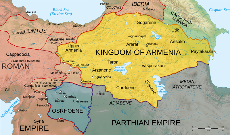
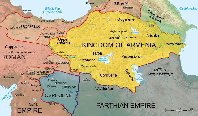
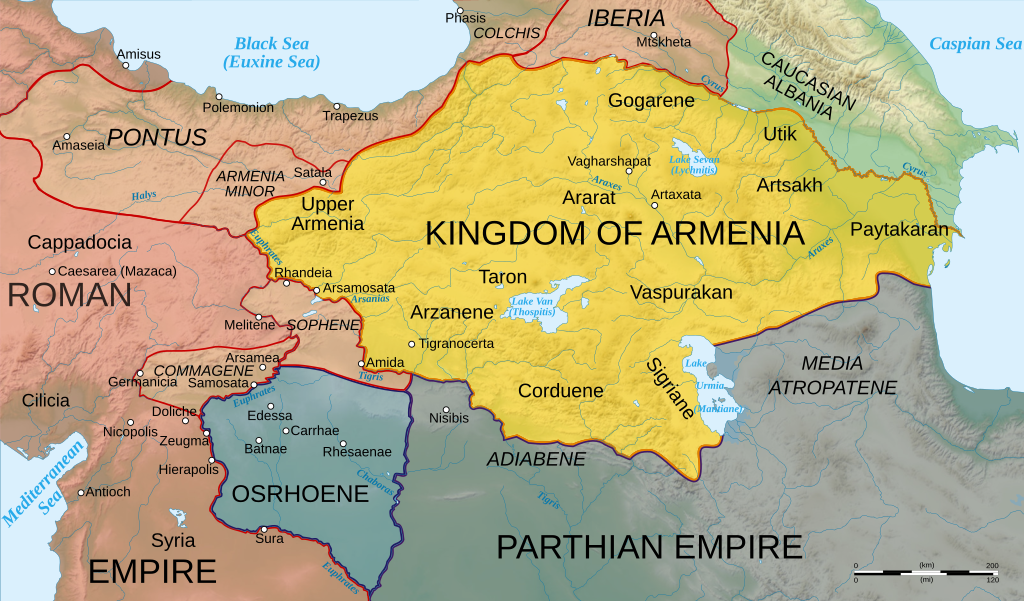
English: Map of Armenia and the Roman client states in eastern Asia Minor, ca. 50 AD, before the Roman-Parthian War and the annexation of the client kingdoms into the Empire. |
| Data | |
| Fonte | Based on Image:Arshakuni Armenia 150-en.svg. Province & client state outlines based on: Atlas of Classical History, Routledge 1985, pp. 160-162; History Map of Europe, Year 1 from Euratlas |
| Autore | Cplakidas |
| Altre versioni |
[]
|


Questa grafica vettoriale non specificata secondo il W3C è stata creata con Inkscape .
Licenza
[modifica]
Io, detentore del copyright su quest'opera, dichiaro di pubblicarla con le seguenti licenze:
Questo file è disponibile in base alla licenza Creative Commons Attribuzione-Condividi allo stesso modo 3.0 Unported
- Tu sei libero:
- di condividere – di copiare, distribuire e trasmettere quest'opera
- di modificare – di adattare l'opera
- Alle seguenti condizioni:
- attribuzione – Devi fornire i crediti appropriati, un collegamento alla licenza e indicare se sono state apportate modifiche. Puoi farlo in qualsiasi modo ragionevole, ma non in alcun modo che suggerisca che il licenziante approvi te o il tuo uso.
- condividi allo stesso modo – Se remixi, trasformi o sviluppi il materiale, devi distribuire i tuoi contributi in base alla stessa licenza o compatibile all'originale.

|
È permesso copiare, distribuire e/o modificare questo documento in base ai termini della GNU Free Documentation License, Versione 1.2 o successive pubblicata dalla Free Software Foundation; senza alcuna sezione non modificabile, senza testo di copertina e senza testo di quarta di copertina. Una copia della licenza è inclusa nella sezione intitolata Testo della GNU Free Documentation License. |
Puoi scegliere la licenza che preferisci.
|
Cronologia del file
Fare clic su un gruppo data/ora per vedere il file come si presentava nel momento indicato.
| Data/Ora | Miniatura | Dimensioni | Utente | Commento | |
|---|---|---|---|---|---|
| attuale | 14:25, 3 nov 2020 | | 2 717 × 1 595 (848 KB) | ԱշոտՏՆՂ (discussione | contributi) | The Mingechevir Reservoir was built in 1953, so I removed it from the map. |
| 14:07, 13 apr 2009 |  | 2 717 × 1 595 (854 KB) | Cplakidas (discussione | contributi) | some more details | |
| 06:48, 8 apr 2009 |  | 2 717 × 1 595 (849 KB) | Cplakidas (discussione | contributi) | trying to fix text problems | |
| 14:35, 7 apr 2009 |  | 2 717 × 1 595 (863 KB) | Cplakidas (discussione | contributi) | bigger captions, minor tweaks | |
| 18:52, 6 apr 2009 |  | 2 717 × 1 595 (847 KB) | Cplakidas (discussione | contributi) | plain svg | |
| 18:47, 6 apr 2009 |  | 2 717 × 1 595 (858 KB) | Cplakidas (discussione | contributi) | {{Information |Description={{en|1=Map of Armenia and the Roman client states in eastern Asia Minor, ca. 50 AD, before the Roman-Parthian War and the annexation of the client kingdoms into the Empire.}} |Source=Based on [[:Image:Arshakuni Armenia 150-en.sv |
Impossibile sovrascrivere questo file.
Utilizzo del file
Le seguenti 18 pagine usano questo file:
- Atlas of Artsakh
- User:Cplakidas
- User:Magog the Ogre/Multilingual legend/2020 November 1-10
- File:Roman-Parthian War 58-60-zh.svg
- File:Roman-Parthian War 58-60.svg
- File:Roman-Parthian War 61-63-zh.svg
- File:Roman-Parthian War 61-63.svg
- File:Roman East 50-ang.svg
- File:Roman East 50-en.svg
- File:Roman East 50-es.svg
- File:Roman East 50-he.svg
- File:Roman East 50-hu.svg
- File:Roman East 50-hy.svg
- File:Roman East 50-it.svg
- File:Roman East 50-pt.svg
- File:Roman East 50-zh.svg
- File:Roman East 50 CE Commagene highlighted-en.svg
- Template:Other versions/Roman East 50
Utilizzo globale del file
Anche i seguenti wiki usano questo file:
- Usato nelle seguenti pagine di ar.wikipedia.org:
- Usato nelle seguenti pagine di arz.wikipedia.org:
- Usato nelle seguenti pagine di azb.wikipedia.org:
- Usato nelle seguenti pagine di az.wikipedia.org:
- Usato nelle seguenti pagine di be.wikipedia.org:
- Usato nelle seguenti pagine di bg.wikipedia.org:
- Usato nelle seguenti pagine di ca.wikipedia.org:
- Usato nelle seguenti pagine di cs.wikipedia.org:
- Usato nelle seguenti pagine di de.wikipedia.org:
- Usato nelle seguenti pagine di el.wikipedia.org:
- Usato nelle seguenti pagine di en.wikipedia.org:
- Germanicus
- Pontus (region)
- Gaius Caesar
- Osroene
- Wikipedia:WikiProject Former countries
- Kingdom of Armenia (antiquity)
- Vologases I of Parthia
- Armenian nobility
- Tiridates I of Armenia
- User:Mcasey666
- Talk:Kingdom of Armenia (antiquity)
- Kingdom of Pontus
- Wikipedia:Featured pictures/Diagrams, drawings, and maps/Maps
- Roman–Parthian War of 58–63
- User:GroveGuy/Sandbox
- User:Cplakidas/Articles
- User:배우는사람/Test
- Classical Anatolia
- User:HistoryofIran/Shervin II
- Wikipedia:Featured pictures thumbs/39
- Kingdom of Bithynia
- Wikipedia:Featured picture candidates/Greater Armenia
- Wikipedia:Featured picture candidates/February-2014
- User talk:Yerevanci/Archive 3
- User talk:Cplakidas/Archive 15
- Wikipedia:Picture of the day/December 2015
- Template:POTD/2015-12-23
- Wikipedia:Main Page history/2015 December 23
- User talk:Cplakidas/Archive 18
- User talk:Yerevanci/Archive 5
- Wikipedia:WikiProject Former countries/Recognized content
- Wikipedia:WikiProject Armenia/Recognized content
Visualizza l'utilizzo globale di questo file.
Metadati
Categorie:
- Maps of the history of the Caucasus in antiquity
- SVG maps of the history of Armenia
- Maps of the history of Georgia
- SVG maps of the history of Azerbaijan
- Maps of the history of the south Caucasus region
- Maps of Colchis
- Maps of the Kingdom of Iberia
- Maps of Caucasian Albania
- Maps of Corduene
- Maps of Sophene
- Maps of Commagene
- Maps of Osrhoene
- Maps of ancient Anatolia
- Maps of Pontus
- Maps showing 1st-century history
- Limes Orientalis
- Parthian-Roman wars
- SVG maps of the ancient Near East
- English-language SVG maps showing history