File:Rzeczpospolita 1600.png
Vai alla navigazione
Vai alla ricerca

Dimensioni di questa anteprima: 765 × 600 pixel. Altre risoluzioni: 306 × 240 pixel | 612 × 480 pixel | 980 × 768 pixel | 1 280 × 1 004 pixel | 2 000 × 1 568 pixel.
File originale (2 000 × 1 568 pixel, dimensione del file: 329 KB, tipo MIME: image/png)
Didascalie
Didascalie
Aggiungi una brevissima spiegazione di ciò che questo file rappresenta

|
Questa immagine (categorizzazione automatica: historical map) o tutte le immagini in questa categoria o galleria dovrebbero essere ricreate usando grafica vettoriale come file SVG. Questo offre diversi vantaggi: vedi Commons:Media for cleanup per maggiori informazioni. Se è disponibile una versione in formato SVG di questa immagine, per favore caricala. Dopo aver caricato un file SVG, sostituisci questo avviso con il template {{Vector version available|nome_immagine.svg}}.
|
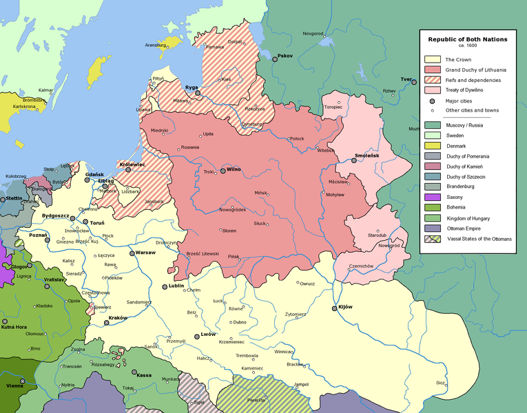
Commonwealth of Both Nations at the peak of its strength, after the Treaty of Dywilino.
The following is a list of maps created by Halibutt and uploaded to commons, as well as their present and projected derivatives.
| Parent Image | Image | Description | |||||||||||
|---|---|---|---|---|---|---|---|---|---|---|---|---|---|
| Maps by Halibutt | |||||||||||||
| Image:Rzeczpospolita.png | Image:Rzeczpospolita.png | The Republic in 17th and 18th century | |||||||||||
| Image:Rzeczpospolita 1600.png | The Republic after the Treaty of Dywilino | ||||||||||||
| Image:Rzeczpospolita voivodships.png | Voivodships of The Republic | ||||||||||||
| Image:Rzeczpospolita_Potop.png | The Republic during The Deluge and Chmielnicki Uprising, with major battles of the era marked | ||||||||||||
| Magnates and their lands and domains | |||||||||||||
| 1st • 2nd • 3rd | Partitions of Poland | ||||||||||||
| War of the constitution | |||||||||||||
| Image:Rzeczpospolita.xcf | SOURCE FILE - GIMP format | ||||||||||||
| Image:Poland 1939.png | Image:Poland 1939.png | Poland in 1939 | |||||||||||
| Image:Dywizje wrzesien 1.png | Order of Battle on September 1st, during the Polish Defence War of 1939 | ||||||||||||
| Image:Poland 1939.xcf | SOURCE FILE - GIMP format | ||||||||||||
| Image:Polska kontur bialy.png | Image:Polska kontur bialy.png | Contour map of Poland AD 1999, for use with various locator maps | |||||||||||
| Image:Rzeczpospolita 1923.png | Image:Rzeczpospolita 1923.png | Map of Poland 1918-1939, currently under development | |||||||||||
| Image:PBW March 1919.png | Polish-Bolshevik War - fronts in March of 1919 | ||||||||||||
| Image:PBW December 1919.png | Polish-Bolshevik War - fronts in December of 1919 | ||||||||||||
| Image:PBW June 1920.png | Polish-Bolshevik War - fronts in July of 1920 | ||||||||||||
| Image:PBW August 1920.png | Polish-Bolshevik War - fronts in August of 1920 | ||||||||||||
| Polish Defence War of 1939 | |||||||||||||
| Polish areas annexed by Germany, Lithuania, Slovakia and the Soviet Union | |||||||||||||
| German concentration camps in Poland | |||||||||||||
| Curzon line | |||||||||||||
| Major battles of the Polish-Bolshevik War | |||||||||||||
| names • no names | Polish/Czechoslovak/Lithuanian/German/Ukrainian claims in 1920's | ||||||||||||
| Image:Rzeczpospolita Central Lithuania.png | Central Lithuania | ||||||||||||
| Image:Rzeczpospolita Lithuania claims.png | Central Lithuania as compared with other Lithuanian claims | ||||||||||||
| Image:Rzeczpospolita 1789-1920.png | Post-1922 borders compared with the territory of Poland before the partitions | ||||||||||||
| Warsaw Uprising and the Operation Tempest | |||||||||||||
| Poland partitioned between the Soviets and the Germans | |||||||||||||
| Image:Rzeczpospolita 1939 Polish divisions.png | Polish divisions on September 1, 1939 | ||||||||||||
| Home Army inspectorates | |||||||||||||
| Image:Rzeczpospolita 1922.xcf | SOURCE FILE - GIMP format | ||||||||||||
| Image:Rzeczpospolita 1937.svg | Vector version!!!! | layered version available on request | |||||||||||
Since the legal status of the above comment has been questioned, I hereby grant anyone the right to treat it as either a standard copyright notice, invariant section, legal statement, legal advice, friendly suggestion or a mere comment, depending on his or hers own choice. |
|

derivative works
[modifica]
Opere derivate da questo file:
Cronologia del file
Fare clic su un gruppo data/ora per vedere il file come si presentava nel momento indicato.
| Data/Ora | Miniatura | Dimensioni | Utente | Commento | |
|---|---|---|---|---|---|
| attuale | 15:53, 10 gen 2016 | | 2 000 × 1 568 (329 KB) | Spiridon Ion Cepleanu (discussione | contributi) | Little cosmetic add in the south of the map (Ottoman domain) according with H.E.Stier (dir.) "Grosser Atlas zur Weltgeschischte", Westermann 1985, ISBN 3-14-10 0919-8, p. 103, and replaced Jampol on the left bank of the Dnister. |
| 13:36, 24 feb 2010 |  | 2 000 × 1 568 (319 KB) | Dcoetzee (discussione | contributi) | Remove watermark, PNGcrush | |
| 20:45, 31 lug 2005 |  | 2 000 × 1 568 (493 KB) | Halibutt (discussione | contributi) | Commonwealth of Both Nations at the peak of its strength, after the Treaty of Dywilino. {{User:Halibutt/maps}} {{User:Halibutt/GFDL}} Category:Historical maps of Poland Category:Historical maps of Ukraine Category:Historical maps of Russia |
Impossibile sovrascrivere questo file.
Utilizzo del file
Le seguenti 4 pagine usano questo file:
Utilizzo globale del file
Anche i seguenti wiki usano questo file:
- Usato nelle seguenti pagine di an.wikipedia.org:
- Usato nelle seguenti pagine di azb.wikipedia.org:
- Usato nelle seguenti pagine di be.wikipedia.org:
- Usato nelle seguenti pagine di ca.wikipedia.org:
- Usato nelle seguenti pagine di cs.wikipedia.org:
- Usato nelle seguenti pagine di da.wikipedia.org:
- Usato nelle seguenti pagine di de.wikipedia.org:
- Usato nelle seguenti pagine di en.wikipedia.org:
- Usato nelle seguenti pagine di et.wikipedia.org:
- Usato nelle seguenti pagine di fi.wikipedia.org:
- Usato nelle seguenti pagine di fr.wikipedia.org:
- Usato nelle seguenti pagine di fr.wiktionary.org:
- Usato nelle seguenti pagine di gd.wikipedia.org:
- Usato nelle seguenti pagine di hr.wikipedia.org:
- Usato nelle seguenti pagine di id.wikipedia.org:
- Usato nelle seguenti pagine di is.wikipedia.org:
- Usato nelle seguenti pagine di it.wikipedia.org:
- Usato nelle seguenti pagine di ja.wikipedia.org:
- Usato nelle seguenti pagine di ka.wikipedia.org:
- Usato nelle seguenti pagine di ko.wikipedia.org:
- Usato nelle seguenti pagine di la.wikipedia.org:
- Usato nelle seguenti pagine di lt.wikipedia.org:
Visualizza l'utilizzo globale di questo file.