File:Saharat Thai Doem map.png
Jump to navigation
Jump to search

Size of this preview: 663 × 600 pixels. Other resolutions: 265 × 240 pixels | 531 × 480 pixels | 962 × 870 pixels.
Original file (962 × 870 pixels, file size: 189 KB, MIME type: image/png)
Captions
Captions
Add a one-line explanation of what this file represents
Summary
[edit]
| Description |
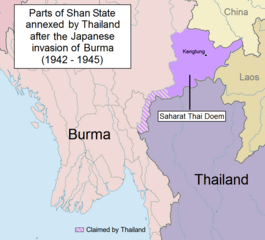
English: Parts of Shan State annexed by Thailand after the Japanese invasion of Burma. The map shows in purple the actual territories east of the Salween (Kengtung and part of Mongpan State) that were sanctioned by the Japanese authorities to become a new Thai province. Not all the territories claimed by Thailand in the Shan and Kayah states were granted by the Japanese.
Note: This is not a map of the farthest penetration of the Thai army accompanying the Japanese military in their Burma campaign. |
| Date | |
| Source | Own work |
| Author | Xufanc |
Licensing
[edit]
I, the copyright holder of this work, hereby publish it under the following license:
This file is licensed under the Creative Commons Attribution-Share Alike 4.0 International license.
- You are free:
- to share – to copy, distribute and transmit the work
- to remix – to adapt the work
- Under the following conditions:
- attribution – You must give appropriate credit, provide a link to the license, and indicate if changes were made. You may do so in any reasonable manner, but not in any way that suggests the licensor endorses you or your use.
- share alike – If you remix, transform, or build upon the material, you must distribute your contributions under the same or compatible license as the original.
File history
Click on a date/time to view the file as it appeared at that time.
| Date/Time | Thumbnail | Dimensions | User | Comment | |
|---|---|---|---|---|---|
| current | 13:01, 24 May 2017 | | 962 × 870 (189 KB) | Xufanc (talk | contribs) | Undid malicious revision by User:Shoshui |
| 03:37, 12 March 2016 |  | 962 × 870 (167 KB) | Shoshui (talk | contribs) | Reverted to version as of 07:52, 6 November 2015 (UTC) | |
| 09:37, 15 December 2015 |  | 962 × 870 (193 KB) | Xufanc (talk | contribs) | Corrected title | |
| 09:08, 15 December 2015 |  | 962 × 870 (194 KB) | Xufanc (talk | contribs) | Other wording | |
| 08:59, 15 December 2015 |  | 962 × 870 (208 KB) | Xufanc (talk | contribs) | Other wording | |
| 01:57, 9 November 2015 |  | 962 × 870 (208 KB) | Xufanc (talk | contribs) | status unclear region | |
| 03:03, 7 November 2015 |  | 962 × 870 (208 KB) | Xufanc (talk | contribs) | Status unclear region | |
| 07:52, 6 November 2015 |  | 962 × 870 (167 KB) | Xufanc (talk | contribs) | Mandalay and Taunggiy was as far as the Thai troops advanced, but the map is about the parts annexed by Thailand as 'Saharat Thai Doem'. It is not a map of the farthest penetration of the Phayap Army | |
| 06:25, 14 September 2015 |  | 962 × 870 (166 KB) | Shoshui (talk | contribs) | The area include Mandalay and Taunggyi. | |
| 06:16, 14 September 2015 |  | 962 × 870 (166 KB) | Shoshui (talk | contribs) | The area include Mandalay and Taunggyi. |
You cannot overwrite this file.
File usage on Commons
The following 6 pages use this file:
- User:Magog the Ogre/Maps of conflicts/2014 August
- User:Magog the Ogre/Maps of conflicts/2015 December
- User:Magog the Ogre/Maps of conflicts/2015 November
- User:Magog the Ogre/Maps of conflicts/2015 September
- User:Magog the Ogre/Maps of conflicts/2016 March
- User:Magog the Ogre/Maps of conflicts/2017 May
File usage on other wikis
The following other wikis use this file:
- Usage on en.wikipedia.org
- Usage on es.wikipedia.org
- Usage on fr.wikipedia.org
- Usage on it.wikipedia.org
- Usage on my.wikipedia.org
- Usage on ru.wikipedia.org
- Usage on th.wikipedia.org
- Usage on uk.wikipedia.org
- Usage on vi.wikipedia.org
- Usage on zh.wikipedia.org