File:Saint Petersburg Tram System Map.svg
Vai alla navigazione
Vai alla ricerca

Dimensioni di questa anteprima PNG per questo file SVG: 512 × 550 pixel. Altre risoluzioni: 223 × 240 pixel | 447 × 480 pixel | 715 × 768 pixel | 953 × 1 024 pixel | 1 906 × 2 048 pixel.
File originale (file in formato SVG, dimensioni nominali 512 × 550 pixel, dimensione del file: 3,8 MB)
Didascalie
Didascalie
Aggiungi una brevissima spiegazione di ciò che questo file rappresenta
| Descrizione |
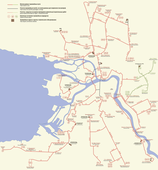
English: Saint Petersburg Tram System Map
Legend:
Русский: Схема трамвайной сети Санкт-Петербурга
Легенда:
|
||||
| Data | |||||
| Fonte | Opera propria | ||||
| Autore | Florstein, OpenStreetMap project editors (for older versions) | ||||
| Licenza (Riusare questo file) |
Alex Florstein, detentore del copyright su quest'opera, dichiara di pubblicarla con le seguenti licenze:
Questo file è disponibile in base alle licenze Creative Commons Attribuzione-Condividi allo stesso modo 3.0 Unported, 2.5 Generico, 2.0 Generico e 1.0 Generico Attribuzione: Alex Florstein
Puoi scegliere la licenza che preferisci.
|

Cronologia del file
Fare clic su un gruppo data/ora per vedere il file come si presentava nel momento indicato.
| Data/Ora | Miniatura | Dimensioni | Utente | Commento | |
|---|---|---|---|---|---|
| attuale | 18:06, 22 feb 2024 | | 512 × 550 (3,8 MB) | Florstein (discussione | contributi) | 2024 update |
| 20:37, 7 mag 2022 |  | 2 728 × 3 016 (3,7 MB) | Florstein (discussione | contributi) | some minor edits | |
| 19:36, 3 mag 2022 |  | 2 728 × 3 016 (3,68 MB) | Florstein (discussione | contributi) | + small addition | |
| 18:57, 3 mag 2022 |  | 2 728 × 3 016 (3,68 MB) | Florstein (discussione | contributi) | + size | |
| 18:45, 3 mag 2022 |  | 512 × 566 (3,68 MB) | Florstein (discussione | contributi) | 05-03-2022 update | |
| 19:41, 1 nov 2019 |  | 2 728 × 3 016 (1,37 MB) | Florstein (discussione | contributi) | 11-01-2019 update | |
| 19:05, 28 dic 2018 |  | 2 728 × 3 016 (4,15 MB) | Florstein (discussione | contributi) | minor | |
| 18:52, 28 dic 2018 |  | 2 728 × 3 016 (4,15 MB) | Florstein (discussione | contributi) | minor | |
| 18:42, 28 dic 2018 |  | 2 728 × 3 016 (4,15 MB) | Florstein (discussione | contributi) | 12-28-2018 update | |
| 20:14, 7 mar 2018 |  | 2 728 × 3 016 (1,36 MB) | Florstein (discussione | contributi) | + 8th |
Impossibile sovrascrivere questo file.
Utilizzo del file
Le seguenti 34 pagine usano questo file:
- User:Chumwa/OgreBot/Potential transport maps/2016 June 1-10
- User:Chumwa/OgreBot/Potential transport maps/2016 September 21-30
- User:Chumwa/OgreBot/Potential transport maps/2017 November 11-20
- User:Chumwa/OgreBot/Potential transport maps/2018 December 21-31
- User:Chumwa/OgreBot/Potential transport maps/2018 March 1-10
- User:Chumwa/OgreBot/Potential transport maps/2019 November 1-10
- User:Chumwa/OgreBot/Public transport information/2015 February 1-9
- User:Chumwa/OgreBot/Public transport information/2016 February 20-29
- User:Chumwa/OgreBot/Public transport information/2016 June 1-10
- User:Chumwa/OgreBot/Public transport information/2016 September 21-30
- User:Chumwa/OgreBot/Public transport information/2017 November 11-20
- User:Chumwa/OgreBot/Public transport information/2018 December 21-31
- User:Chumwa/OgreBot/Public transport information/2018 March 1-10
- User:Chumwa/OgreBot/Public transport information/2019 November 1-10
- User:Chumwa/OgreBot/Public transport information/2022 May 1-10
- User:Chumwa/OgreBot/Public transport information/2024 February 20-29
- User:Chumwa/OgreBot/Transport Maps/2015 February 1-9
- User:Chumwa/OgreBot/Transport Maps/2016 February 20-29
- User:Chumwa/OgreBot/Transport Maps/2016 June 1-10
- User:Chumwa/OgreBot/Transport Maps/2016 September 21-30
- User:Chumwa/OgreBot/Transport Maps/2017 November 11-20
- User:Chumwa/OgreBot/Transport Maps/2018 December 21-31
- User:Chumwa/OgreBot/Transport Maps/2018 March 1-10
- User:Chumwa/OgreBot/Transport Maps/2019 November 1-10
- User:Chumwa/OgreBot/Transport Maps/2022 May 1-10
- User:Chumwa/OgreBot/Transport Maps/2024 February 20-29
- User:Chumwa/OgreBot/Travel and communication maps/2016 February 20-29
- User:Chumwa/OgreBot/Travel and communication maps/2016 June 1-10
- User:Chumwa/OgreBot/Travel and communication maps/2016 September 21-30
- User:Chumwa/OgreBot/Travel and communication maps/2017 November 11-20
- User:Chumwa/OgreBot/Travel and communication maps/2018 December 21-31
- User:Chumwa/OgreBot/Travel and communication maps/2018 March 1-10
- User:Liesel/Rail transport/2015 February 1-9
- Category:Tram transport in Saint Petersburg
Utilizzo globale del file
Anche i seguenti wiki usano questo file:
- Usato nelle seguenti pagine di cs.wikipedia.org:
- Usato nelle seguenti pagine di de.wikipedia.org:
- Usato nelle seguenti pagine di en.wikipedia.org:
- Usato nelle seguenti pagine di en.wikivoyage.org:
- Usato nelle seguenti pagine di eo.wikipedia.org:
- Usato nelle seguenti pagine di fr.wikipedia.org:
- Usato nelle seguenti pagine di he.wikipedia.org:
- Usato nelle seguenti pagine di it.wikipedia.org:
- Usato nelle seguenti pagine di ja.wikipedia.org:
- Usato nelle seguenti pagine di lt.wikipedia.org:
- Usato nelle seguenti pagine di nl.wikipedia.org:
- Usato nelle seguenti pagine di pl.wikipedia.org:
- Usato nelle seguenti pagine di pl.wikivoyage.org:
- Usato nelle seguenti pagine di ru.wikipedia.org:
- Usato nelle seguenti pagine di sk.wikipedia.org:
- Usato nelle seguenti pagine di sv.wikipedia.org:
- Usato nelle seguenti pagine di tr.wikipedia.org:
- Usato nelle seguenti pagine di uk.wikipedia.org:
- Usato nelle seguenti pagine di www.wikidata.org:
- Usato nelle seguenti pagine di zh.wikipedia.org: