File:SantaCatarina Municip Florianopolis.svg

Original file (SVG file, nominally 943 × 691 pixels, file size: 623 KB)
Captions
Captions

|
Standardization of derivative maps
Feel free to create derivations of this work, but if you want to illustrate a Wikipedia article with derivative works of this or similar maps of Brazil, please strictly follow the visual standard, nomenclature and classification already in use. All maps of Brazilian subdivisions are being adaptated or created in this way. We do not want to inhibit creativity but the pattern adopted here was presented and accepted by the Lusophone community and should be followed whenever possible. |
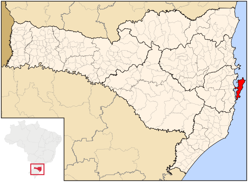
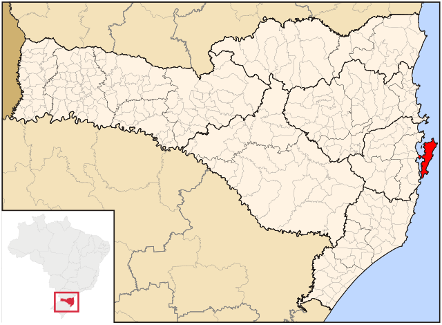
| Description | Map locator of Santa Catarina's Florianópolis city | ||||||||
| Date | |||||||||
| Source | Image:SantaCatarina MesoMicroMunicip.svg, Raphael Lorenzeto de Abreu | ||||||||
| Author | Cícero Henrique Rodrigues | ||||||||
| Permission (Reusing this file) |
I, the copyright holder of this work, hereby publish it under the following licenses:
This file is licensed under the Creative Commons Attribution 2.5 Generic license.
You may select the license of your choice. |

File history
Click on a date/time to view the file as it appeared at that time.
| Date/Time | Thumbnail | Dimensions | User | Comment | |
|---|---|---|---|---|---|
| current | 16:02, 24 August 2021 | | 943 × 691 (623 KB) | Allice Hunter (talk | contribs) | Reverted to version as of 06:26, 24 June 2006 (UTC) |
| 15:21, 24 August 2021 |  | 512 × 375 (320 KB) | Allice Hunter (talk | contribs) | Adjusting | |
| 15:11, 24 August 2021 |  | 512 × 375 (425 KB) | Allice Hunter (talk | contribs) | Final version | |
| 15:03, 24 August 2021 |  | 512 × 375 (448 KB) | Allice Hunter (talk | contribs) | Adjusting | |
| 15:01, 24 August 2021 |  | 512 × 375 (590 KB) | Allice Hunter (talk | contribs) | Those regions no longer exist | |
| 06:26, 24 June 2006 |  | 943 × 691 (623 KB) | Cicerohr (talk | contribs) | Map locator of Santa Catarina's Florianópolis city |
You cannot overwrite this file.
File usage on Commons
The following 7 pages use this file:
File usage on other wikis
The following other wikis use this file:
- Usage on af.wikipedia.org
- Usage on ar.wikipedia.org
- Usage on ast.wikipedia.org
- Usage on bpy.wikipedia.org
- Usage on ca.wikipedia.org
- Usage on ceb.wikipedia.org
- Usage on ckb.wikipedia.org
- Usage on de.wikipedia.org
- Usage on el.wikipedia.org
- Usage on en.wikipedia.org
- Usage on eo.wikipedia.org
- Usage on es.wikipedia.org
- Usage on eu.wikipedia.org
- Usage on fa.wikipedia.org
- Usage on fi.wikipedia.org
- Usage on fr.wikipedia.org
- Usage on ga.wikipedia.org
- Usage on gl.wikipedia.org
- Usage on gn.wikipedia.org
- Usage on he.wikipedia.org
- Usage on hu.wikipedia.org
- Usage on ia.wikipedia.org
- Usage on id.wikipedia.org
- Usage on io.wikipedia.org
- Usage on is.wikipedia.org
- Usage on it.wikipedia.org
- Usage on ja.wikipedia.org
- Usage on lmo.wikipedia.org
- Usage on mr.wikipedia.org
- Usage on nl.wikipedia.org
- Usage on no.wikipedia.org
- Usage on pt.wikipedia.org
- Usage on pt.wikivoyage.org
- Usage on ro.wikipedia.org
- Usage on sco.wikipedia.org
- Usage on sk.wikipedia.org
- Usage on sr.wikipedia.org
- Usage on sv.wikipedia.org
- Usage on th.wikipedia.org
View more global usage of this file.