File:Sarantaporo.png
Jump to navigation
Jump to search
No higher resolution available.
Sarantaporo.png (743 × 564 pixels, file size: 639 KB, MIME type: image/png)
Captions
Captions
Add a one-line explanation of what this file represents
Summary[edit]
| Description |
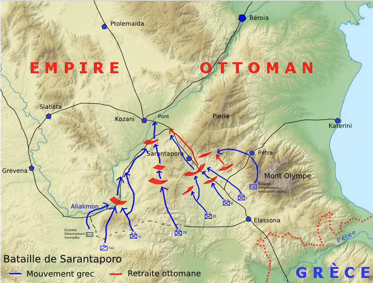
Français : Carte de la bataille de Sarantaporo (9/21 - 10/22 octobre 1912) English: Map of Sarandaporo battle in First Balkan War (September 21st - October 22nd, 1912 Deutsch: Karte der Schlacht von Sarandaporo (21. September bis 22. Oktober 1912). |
| Date | |
| Source | Own work based on page 291 of Christopoulos, Georgios and Bastias, Ioannis (1977). Ιστορία του Ελληνικού Εθνους: Νεώτερος Ελληνισμός απο το 1881 ως 1913 [History of the Greek Nation: Modern Greece from 1881 until 1913] (in Greek). XIV. Athens: Ekdotiki Athinon. |
| Author | Cédric Boissière à partir d'un fond de carte de Sting |
Licensing[edit]
I, the copyright holder of this work, hereby publish it under the following licenses:

|
Permission is granted to copy, distribute and/or modify this document under the terms of the GNU Free Documentation License, Version 1.2 or any later version published by the Free Software Foundation; with no Invariant Sections, no Front-Cover Texts, and no Back-Cover Texts. A copy of the license is included in the section entitled GNU Free Documentation License. |
This file is licensed under the Creative Commons Attribution-Share Alike 3.0 Unported, 2.5 Generic, 2.0 Generic and 1.0 Generic license.
- You are free:
- to share – to copy, distribute and transmit the work
- to remix – to adapt the work
- Under the following conditions:
- attribution – You must give appropriate credit, provide a link to the license, and indicate if changes were made. You may do so in any reasonable manner, but not in any way that suggests the licensor endorses you or your use.
- share alike – If you remix, transform, or build upon the material, you must distribute your contributions under the same or compatible license as the original.
You may select the license of your choice.
File history
Click on a date/time to view the file as it appeared at that time.
| Date/Time | Thumbnail | Dimensions | User | Comment | |
|---|---|---|---|---|---|
| current | 10:11, 9 August 2014 | | 743 × 564 (639 KB) | Spiridon Ion Cepleanu (talk | contribs) | Placed Petra & greek-turkish border until 1912 (since Stiers Hand-Atlas, Julius Perthes, Gotha 1910) |
| 15:52, 7 December 2008 |  | 743 × 564 (712 KB) | O Kolymbitès (talk | contribs) | {{Information |Description=Carte de la bataille de Sarantaporo (9/21 - 10/22 octobre 1912) |Source=self-made |Date=7 décembre 2008 |Author= Cédric Boissière à partir d'un fond de carte / from de/of {{u|Sting}} |Permission= |
You cannot overwrite this file.
File usage on Commons
The following page uses this file:
File usage on other wikis
The following other wikis use this file:
- Usage on ar.wikipedia.org
- Usage on az.wikipedia.org
- Usage on bg.wikipedia.org
- Usage on bs.wikipedia.org
- Usage on ca.wikipedia.org
- Usage on de.wikipedia.org
- Usage on el.wikipedia.org
- Usage on en.wikipedia.org
- Usage on fr.wikipedia.org
- Usage on hy.wikipedia.org
- Usage on it.wikipedia.org
- Usage on nl.wikipedia.org
- Usage on pl.wikipedia.org
- Usage on ru.wikipedia.org
- Usage on sq.wikipedia.org
- Usage on tr.wikipedia.org
- Usage on uk.wikipedia.org
- Usage on www.wikidata.org