File:Serbia1718 1739.png
Jump to navigation
Jump to search
Size of this preview: 692 × 599 pixels. Other resolutions: 277 × 240 pixels | 554 × 480 pixels | 851 × 737 pixels.
Original file (851 × 737 pixels, file size: 71 KB, MIME type: image/png)
Captions
Captions
Add a one-line explanation of what this file represents
Summary
[edit]
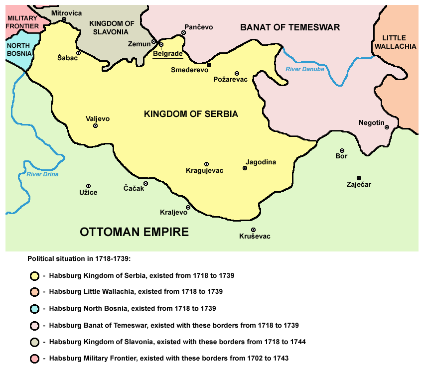
- English: Kingdom of Serbia under Austrian administration (1718-1739).
- Serbian: Краљевина Србија под аустријском управом, 1718-1739.
References
[edit]
Published references:
- The Times History of Europe, Times Books, London, 2002.
- Istorijski atlas, Zavod za udžbenike i nastavna sredstva - Zavod za kartografiju "Geokarta", Beograd, 1999.
- Školski istorijski atlas, Zavod za izdavanje udžbenika Socijalističke Republike Srbije, Beograd, 1970.
- Denis Šehić - Demir Šehić, Istorijski atlas Sveta, Beograd, 2007.
- Olga Zirojević, Srbija pod turskom vlašću 1459-1804, Beograd, 2007.
- Vladimir Ćorović, Ilustrovana istorija Srba, knjiga četvrta, Beograd, 2006.
- Peter Rokai - Zoltan Đere - Tibor Pal - Aleksandar Kasaš, Istorija Mađara, Beograd, 2002.
- Stanoje Stanojević, Istorija srpskog naroda, Beograd, 2009.
Internet references:
- http://www.conflicts.rem33.com/images/Ungarn/OESTEREICH%20ENTWICKLUNG.jpg
- http://terkepek.adatbank.transindex.ro/kepek/netre/51.gif
- http://upload.wikimedia.org/wikipedia/commons/8/8e/Growth_of_Habsburg_territories.jpg
- http://images.nationmaster.com/images/motw/historical/ward_1912/south_east_europe_1648.jpg archive copy at the Wayback Machine
- http://dic.academic.ru/pictures/dewiki/80/Passarowitz_1718.JPG
- http://upload.wikimedia.org/wikipedia/commons/7/7c/Temeswarer_Banat.JPG
- http://gettysburg.cdmhost.com/cdm4/item_viewer.php?CISOROOT=/p4016coll7&CISOPTR=429&CISOBOX=1&REC=2 archive copy at the Wayback Machine
- http://www.garwood-voigt.com/catalogues/H22365SclavoniaeHomann.jpg
- http://upload.wikimedia.org/wikisource/sr/a/a7/Sstanishs7.JPG
Licensing
[edit]

|
This map has been uploaded by Electionworld from en.wikipedia.org to enable the |
Self-made map by PANONIAN
| This work has been released into the public domain by its author, PANONIAN. This applies worldwide. In some countries this may not be legally possible; if so: |
File history
Click on a date/time to view the file as it appeared at that time.
| Date/Time | Thumbnail | Dimensions | User | Comment | |
|---|---|---|---|---|---|
| current | 09:44, 7 September 2013 | | 851 × 737 (71 KB) | WikiEditor2004 (talk | contribs) | minor change |
| 18:22, 13 February 2013 |  | 852 × 737 (71 KB) | WikiEditor2004 (talk | contribs) | corrections | |
| 09:11, 24 December 2009 |  | 852 × 708 (64 KB) | WikiEditor2004 (talk | contribs) | aesthetics | |
| 20:51, 9 August 2009 |  | 852 × 708 (64 KB) | WikiEditor2004 (talk | contribs) | ||
| 20:00, 9 August 2009 |  | 852 × 708 (64 KB) | WikiEditor2004 (talk | contribs) | ||
| 22:53, 8 August 2009 |  | 852 × 774 (56 KB) | Olahus (talk | contribs) | legend | |
| 22:49, 8 August 2009 |  | 852 × 774 (61 KB) | Olahus (talk | contribs) | Only one Kingdom of Serbia. | |
| 22:46, 8 August 2009 |  | 852 × 774 (63 KB) | Olahus (talk | contribs) | Corrections on Banat of Temesvar. | |
| 20:36, 7 August 2009 |  | 852 × 774 (74 KB) | WikiEditor2004 (talk | contribs) | ||
| 13:34, 7 August 2009 |  | 857 × 522 (15 KB) | WikiEditor2004 (talk | contribs) | Reverted to version as of 21:40, 21 December 2006 according to which source? see talk page |
You cannot overwrite this file.
File usage on Commons
The following 2 pages use this file:
File usage on other wikis
The following other wikis use this file:
- Usage on ast.wikipedia.org
- Usage on bg.wikipedia.org
- Usage on ca.wikipedia.org
- Usage on de.wikipedia.org
- Usage on el.wikipedia.org
- Usage on en.wikipedia.org
- Usage on es.wikipedia.org
- Usage on et.wikipedia.org
- Usage on fr.wikipedia.org
- Usage on gl.wikipedia.org
- Usage on he.wikipedia.org
- Usage on id.wikipedia.org
- Usage on it.wikipedia.org
- Usage on ja.wikipedia.org
- Usage on mk.wikipedia.org
- Usage on pnb.wikipedia.org
- Usage on ru.wikipedia.org
- Usage on sh.wikipedia.org
- Usage on sl.wikipedia.org
- Usage on sq.wikipedia.org
- Usage on tr.wikipedia.org
- Usage on uk.wikipedia.org
- Usage on ur.wikipedia.org
- Usage on www.wikidata.org