File:Singapore Diplomatic missions.PNG
Jump to navigation
Jump to search

Size of this preview: 800 × 351 pixels. Other resolutions: 320 × 140 pixels | 640 × 281 pixels | 1,425 × 625 pixels.
Original file (1,425 × 625 pixels, file size: 64 KB, MIME type: image/png)
Captions
Captions
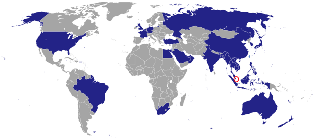
Map showing countries in which Singapore has resident bilateral diplomatic missions. Dark blue: Embassy/High Comission; light blue: Consulate/Consulate-General/Trade Office; not shown: Permanent Missions to International Organisations.
Summary[edit]
| Description |
English: A world map showing countries of the world that Singapore has diplomatic missions in. |
| Date | Originally uploaded to en.wikipedia on 2 August 2008. |
| Source | Transferred from en.wikipedia to Commons by 2T using CommonsHelper. |
| Author | Original uploader was Groubani at en.wikipedia. |
Licensing[edit]

|
Permission is granted to copy, distribute and/or modify this document under the terms of the GNU Free Documentation License, Version 1.2 or any later version published by the Free Software Foundation; with no Invariant Sections, no Front-Cover Texts, and no Back-Cover Texts. A copy of the license is included in the section entitled GNU Free Documentation License. |
| This file is licensed under the Creative Commons Attribution-Share Alike 3.0 Unported license. | ||
| ||
| This licensing tag was added to this file as part of the GFDL licensing update. |
Original upload log[edit]
The original description page was here. All following user names refer to en.wikipedia.
- 2008-08-02 11:38 Groubani 1425×625× (50737 bytes)
File history
Click on a date/time to view the file as it appeared at that time.
| Date/Time | Thumbnail | Dimensions | User | Comment | |
|---|---|---|---|---|---|
| current | 21:54, 8 January 2024 | | 1,425 × 625 (64 KB) | Aquintero82 (talk | contribs) | Added Palestine (light blue) |
| 15:46, 20 November 2023 |  | 1,425 × 625 (64 KB) | Aquintero82 (talk | contribs) | Changed color of Bangladesh | |
| 17:25, 4 January 2023 |  | 1,425 × 625 (64 KB) | Aquintero82 (talk | contribs) | Changed color of Oman | |
| 05:54, 26 November 2022 |  | 1,425 × 625 (65 KB) | Aquintero82 (talk | contribs) | Added Israel | |
| 04:18, 12 July 2022 |  | 1,425 × 625 (65 KB) | Aquintero82 (talk | contribs) | Updated map | |
| 22:37, 5 February 2015 |  | 1,425 × 625 (64 KB) | Aquintero82 (talk | contribs) | Added consulate-general in Oman | |
| 19:49, 5 February 2013 |  | 1,425 × 625 (58 KB) | Aquintero82 (talk | contribs) | Added Turkey | |
| 15:50, 6 October 2012 |  | 1,425 × 625 (57 KB) | Aquintero82 (talk | contribs) | Added Brazil | |
| 00:41, 9 June 2012 |  | 1,425 × 625 (57 KB) | Aquintero82 (talk | contribs) | Changed Bangladesh into a consulate | |
| 00:36, 9 June 2012 |  | 1,425 × 625 (57 KB) | Aquintero82 (talk | contribs) | updated map |
You cannot overwrite this file.
File usage on Commons
There are no pages that use this file.
File usage on other wikis
The following other wikis use this file:
- Usage on de.wikipedia.org
- Usage on en.wikipedia.org
- Usage on es.wikipedia.org
- Usage on id.wikipedia.org
- Usage on ja.wikipedia.org
- Usage on ko.wikipedia.org
- Usage on ms.wikipedia.org
- Usage on pt.wikipedia.org
- Usage on th.wikipedia.org
- Usage on zh.wikipedia.org