File:Southeast Metro Manila Interchange.png
Jump to navigation
Jump to search

Size of this preview: 378 × 600 pixels. Other resolutions: 151 × 240 pixels | 600 × 952 pixels.
Original file (600 × 952 pixels, file size: 952 KB, MIME type: image/png)
Captions
Captions
Add a one-line explanation of what this file represents
Summary[edit]
| Description |
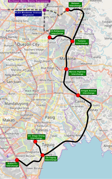
This map of Metro Manila and Municipalities of Cainta, Taytay, San Mateo and City of Antipolo in Rizal Province that show the alignment of the Southeast Metro Manila Expressway was created from OpenStreetMap project data, collected by the community. This map may be incomplete, and may contain errors. Don't rely solely on it for navigation. |
|||||||||
| Date | (see file history) | |||||||||
| Source | openstreetmap.org | |||||||||
| Creator |
OpenStreetMap contributors |
|||||||||
| Permission (Reusing this file) |
OpenStreetMap data and maps are licensed under the Creative Commons Attribution-ShareAlike 2.0 license (CC-BY-SA 2.0). This file is licensed under the Creative Commons Attribution-Share Alike 2.0 Generic license.
|
|||||||||
| Geotemporal data | ||||||||||
| Bounding box |
|
|||||||||
| Georeferencing | If inappropriate please set warp_status = skip to hide. | |||||||||
File history
Click on a date/time to view the file as it appeared at that time.
| Date/Time | Thumbnail | Dimensions | User | Comment | |
|---|---|---|---|---|---|
| current | 18:08, 17 February 2018 | | 600 × 952 (952 KB) | Exec8 (talk | contribs) | Correct name |
| 16:42, 17 February 2018 |  | 504 × 799 (722 KB) | Exec8 (talk | contribs) | Signage | |
| 16:41, 17 February 2018 |  | 504 × 799 (719 KB) | Exec8 (talk | contribs) | Larger image | |
| 16:37, 17 February 2018 |  | 427 × 677 (511 KB) | Exec8 (talk | contribs) | {{OpenStreetMap |odbl=no |location= Metro Manila and Municipalities of Cainta, Taytay, San Mateo and City of Antipolo in Rizal Province that show the alignment of the Southeast Metro Manila Expressway |authors=[... |
You cannot overwrite this file.
File usage on Commons
The following page uses this file:
File usage on other wikis
The following other wikis use this file:
- Usage on en.wikipedia.org
- Usage on tl.wikipedia.org
- Usage on www.wikidata.org