File:Soviet Navy Bases 1984.png
Vai alla navigazione
Vai alla ricerca
Dimensioni di questa anteprima: 800 × 370 pixel. Altre risoluzioni: 320 × 148 pixel | 640 × 296 pixel | 1 357 × 628 pixel.
File originale (1 357 × 628 pixel, dimensione del file: 41 KB, tipo MIME: image/png)
Didascalie
Didascalie
Aggiungi una brevissima spiegazione di ciò che questo file rappresenta
| Descrizione |
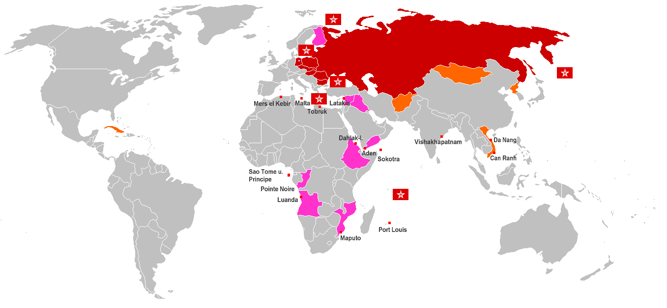
English: World Map of Soviet Navy Bases and anchor rights (red cubes with name). Red countries are Warsaw Pact member states, Orange countries are States with special treaty of mutual assistance and friendship with the Soviet Union, Pink countries are States with special treaty of mutual assistance and friendship since 1970, Flags are Fleets of the Soviet Navy Deutsch: Weltkarte der sowjetischen Marinebasen und Ankerrechte (roter Würfel). Rot eingefärbte Länder sind Warschauer Pakt-Staaten, orange eingefärbte sind Staaten mit einem Freundschafts- und Beistandsabkommen mit besonderer Bindung zur Sowjetunion, rosa eingefärbte Länder sind Staaten mit sonstige Freundschafts- und Beistandsabkommen, bzw. Militärhilfeabkommen ab 1970, Gösch-Flaggen sind Flotten und Detachements der Sowjetischen Marine (Nordmeerflotte, Baltische Flotte, Schwarzmeer-Flotte, Pazifikflotte und Detachements im Mittelmeer (Eskadra) und im Indischen Ozean |
| Data | |
| Fonte | Opera propria |
| Autore | Wikifreund, Germany |
| Licenza (Riusare questo file) |
Questo file è disponibile in base alla licenza Creative Commons Attribuzione 2.0 Generico
|
Cronologia del file
Fare clic su un gruppo data/ora per vedere il file come si presentava nel momento indicato.
| Data/Ora | Miniatura | Dimensioni | Utente | Commento | |
|---|---|---|---|---|---|
| attuale | 02:05, 17 feb 2009 | | 1 357 × 628 (41 KB) | Disposable.Heroes (discussione | contributi) | pngcrush |
| 21:08, 10 ott 2008 |  | 1 357 × 628 (55 KB) | Milosevo (discussione | contributi) | {{Information |Description= |Source= |Date= |Author= |Permission= |other_versions= }} | |
| 11:05, 25 lug 2007 |  | 1 357 × 628 (46 KB) | Wikifreund (discussione | contributi) | {{Information |Description={{en|World Map of Soviet Navy Bases and anchor rights (= red cubes with name). Red countries = Warsaw Pact member states, Orange countries = States with special treaty of mutual assistance and friendship with the Soviet Union, P |
Impossibile sovrascrivere questo file.
Utilizzo del file
Nessuna pagina utilizza questo file.
Utilizzo globale del file
Anche i seguenti wiki usano questo file:
- Usato nelle seguenti pagine di ba.wikipedia.org:
- Usato nelle seguenti pagine di be-tarask.wikipedia.org:
- Usato nelle seguenti pagine di be.wikipedia.org:
- Usato nelle seguenti pagine di bg.wikipedia.org:
- Usato nelle seguenti pagine di ca.wikipedia.org:
- Usato nelle seguenti pagine di cs.wikipedia.org:
- Usato nelle seguenti pagine di da.wikipedia.org:
- Usato nelle seguenti pagine di de.wikipedia.org:
- Usato nelle seguenti pagine di en.wikipedia.org:
- Usato nelle seguenti pagine di es.wikipedia.org:
- Usato nelle seguenti pagine di fi.wikipedia.org:
- Usato nelle seguenti pagine di fr.wikipedia.org:
- Usato nelle seguenti pagine di it.wikipedia.org:
- Usato nelle seguenti pagine di ja.wikipedia.org:
- Usato nelle seguenti pagine di ko.wikipedia.org:
- Usato nelle seguenti pagine di ru.wikipedia.org:
- Usato nelle seguenti pagine di tr.wikipedia.org:
- Usato nelle seguenti pagine di uk.wikipedia.org:
- Usato nelle seguenti pagine di www.wikidata.org:
- Usato nelle seguenti pagine di zh.wikipedia.org: