File:Suwałki gap NATO CSTO.svg
Jump to navigation
Jump to search

Size of this PNG preview of this SVG file: 512 × 523 pixels. Other resolutions: 235 × 240 pixels | 470 × 480 pixels | 752 × 768 pixels | 1,002 × 1,024 pixels | 2,005 × 2,048 pixels.
Original file (SVG file, nominally 512 × 523 pixels, file size: 669 KB)
Captions
Captions
Add a one-line explanation of what this file represents
Summary
[edit]
| Description |
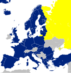
English: European continent, with NATO members (deep blue), CSTO members (yellow) and the Polish-Lithuanian border (red). The Suwałki gap, southwest of the border, is a NATO vulnerability, which, if captured, will cut off the Baltic states from the rest of NATO. The territory of Crimea is de facto administered by Russia, thus de facto part of CSTO, though the vast majority of countries does not recognise Russia's annexation of the peninsula in 2014. |
| Date | |
| Source | Own work, based on File:Blank map of Europe cropped.svg |
| Author | Szmenderowiecki |
Licensing
[edit]
I, the copyright holder of this work, hereby publish it under the following license:
This file is licensed under the Creative Commons Attribution-Share Alike 4.0 International license.
- You are free:
- to share – to copy, distribute and transmit the work
- to remix – to adapt the work
- Under the following conditions:
- attribution – You must give appropriate credit, provide a link to the license, and indicate if changes were made. You may do so in any reasonable manner, but not in any way that suggests the licensor endorses you or your use.
- share alike – If you remix, transform, or build upon the material, you must distribute your contributions under the same or compatible license as the original.
File history
Click on a date/time to view the file as it appeared at that time.
| Date/Time | Thumbnail | Dimensions | User | Comment | |
|---|---|---|---|---|---|
| current | 16:44, 11 April 2024 | | 512 × 523 (669 KB) | Iktsokh (talk | contribs) | Azerbaijan has regained de facto control over its internationally recognized territory (Republic of Artsakh completely ceases to exist from January 1, 2024). |
| 21:30, 7 March 2024 |  | 512 × 523 (672 KB) | Iktsokh (talk | contribs) | Sweden | |
| 15:08, 21 July 2023 |  | 512 × 523 (520 KB) | Iktsokh (talk | contribs) | Finland | |
| 13:46, 20 November 2022 |  | 512 × 523 (523 KB) | M.Bitton (talk | contribs) | Reverted to version as of 02:13, 19 November 2022 (UTC): per COM:OVERWRITE Feel free to upload under a different name | |
| 09:34, 20 November 2022 |  | 512 × 523 (545 KB) | Рагин1987 (talk | contribs) | Armenia and Kazakhstan are members of the CSTO, they are shaded in the map source. | |
| 02:13, 19 November 2022 |  | 512 × 523 (523 KB) | M.Bitton (talk | contribs) | Reverted to version as of 15:11, 29 April 2022 (UTC): who asked you to "extend the map" and for what purpose? | |
| 19:12, 18 November 2022 |  | 512 × 523 (545 KB) | Рагин1987 (talk | contribs) | Extended map | |
| 15:11, 29 April 2022 |  | 512 × 523 (523 KB) | Szmenderowiecki (talk | contribs) | More prominent border | |
| 15:10, 29 April 2022 |  | 512 × 523 (523 KB) | Szmenderowiecki (talk | contribs) | Greenland is part of NATO | |
| 18:22, 29 March 2022 |  | 512 × 523 (533 KB) | Szmenderowiecki (talk | contribs) | Adding am, kz |
You cannot overwrite this file.
File usage on Commons
The following page uses this file:
File usage on other wikis
The following other wikis use this file:
- Usage on it.wikipedia.org
- Usage on uk.wikipedia.org
- Usage on www.wikidata.org