File:Taunus - Deutsche Mittelgebirge, Serie A-de.png

לקובץ המקורי (2,300 × 1,500 פיקסלים, גודל הקובץ: 5.05 מ"ב, סוג MIME: image/png)
כיתובים
כיתובים
תקציר
[עריכה]| תיאור |
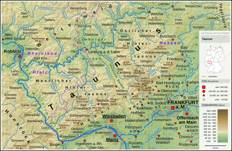
English: Topographic map of the Taunus
Deutsch: Topografische Karte des Taunus |
||||||||||||||||||
| תאריך יצירה | |||||||||||||||||||
| מקור |
נוצר על ידי מעלה היצירה, תוך שימוש: |
||||||||||||||||||
| יוצר | Thoroe | ||||||||||||||||||
| גרסאות אחרות |
 Topographic maps of German low mountain ranges (A series)
This map series aims to show the major low mountain ranges of Germany in a uniform design. All maps are created on the same scale, and the background reliefs base upon the same color scheme. The reliefs are also available as separate files. You can find the making-of one of the maps in the German language Wikipedia (German only).
|
||||||||||||||||||


_-_Deutsche_Mittelgebirge,_Serie_A-de.png)
_-_Deutsche_Mittelgebirge,_Serie_A-de.png)
_-_Deutsche_Mittelgebirge,_Serie_A-de.png)
_-_Deutsche_Mittelgebirge,_Serie_A-de.png)
_-_Deutsche_Mittelgebirge,_Serie_A-de.png)
_-_Deutsche_Mittelgebirge,_Serie_A-de.png)
_-_Deutsche_Mittelgebirge,_Serie_A-de.png)
_-_Deutsche_Mittelgebirge,_Serie_A-de.png)
_-_Deutsche_Mittelgebirge,_Serie_A-de.png)
_-_Deutsche_Mittelgebirge,_Serie_A-de.png)
_-_Deutsche_Mittelgebirge,_Serie_A-de.png)
_-_Deutsche_Mittelgebirge,_Serie_A-de.png)
_-_Deutsche_Mittelgebirge,_Serie_A-de.png)
_-_Deutsche_Mittelgebirge,_Serie_A-de.png)
_-_Deutsche_Mittelgebirge,_Serie_A-de.png)
_-_Deutsche_Mittelgebirge,_Serie_A-de.png)
_-_Deutsche_Mittelgebirge,_Serie_A-de.png)
_-_Deutsche_Mittelgebirge,_Serie_A-de.png)
_-_Deutsche_Mittelgebirge,_Serie_A-de.png)
_-_Deutsche_Mittelgebirge,_Serie_A-de.png)
_-_Deutsche_Mittelgebirge,_Serie_A-de.png)
_-_Deutsche_Mittelgebirge,_Serie_A-de.png)
_-_Deutsche_Mittelgebirge,_Serie_A-de.png)
_-_Deutsche_Mittelgebirge,_Serie_A-de.png)
_-_Deutsche_Mittelgebirge,_Serie_A-de.png)
_-_Deutsche_Mittelgebirge,_Serie_A-de.png)
_-_Deutsche_Mittelgebirge,_Serie_A-de.png)
_-_Deutsche_Mittelgebirge,_Serie_A-de.png)
_-_Deutsche_Mittelgebirge,_Serie_A-de.png)
_-_Deutsche_Mittelgebirge,_Serie_A-de.png)
_-_Deutsche_Mittelgebirge,_Serie_A-de.png)
_-_Deutsche_Mittelgebirge,_Serie_A-de.png)
| This work contains information from OpenStreetMap, which is made available under the Open Database License (ODbL).
The ODbL does not require any particular license for maps produced from ODbL data. Prior to 1 August 2020, map tiles produced by the OpenStreetMap Foundation were licensed under the CC-BY-SA-2.0 license. Maps produced by other people may be subject to other licences. |

|
This map has been made or improved in the German Kartenwerkstatt (Map Lab). You can propose maps to improve as well.
|
רישיון
[עריכה]
- הנכם רשאים:
- לשתף – להעתיק, להפיץ ולהעביר את העבודה
- לערבב בין עבודות – להתאים את העבודה
- תחת התנאים הבאים:
- ייחוס – יש לתת ייחוס הולם, לתת קישור לרישיון, ולציין אם נעשו שינויים. אפשר לעשות את זה בכל צורה סבירה, אבל לא בשום צורה שמשתמע ממנה שמעניק הרישיון תומך בך או בשימוש שלך.
- שיתוף זהה – אם תיצרו רמיקס, תשנו, או תבנו על החומר, חובה עליכם להפיץ את התרומות שלך לפי תנאי רישיון זהה או תואם למקור.
| Annotations | This image is annotated: View the annotations at Commons |
היסטוריית הקובץ
ניתן ללחוץ על תאריך/שעה כדי לראות את הקובץ כפי שנראה באותו זמן.
| תאריך/שעה | תמונה ממוזערת | ממדים | משתמש | הערה | |
|---|---|---|---|---|---|
| נוכחית | 23:16, 12 בינואר 2017 | | 1,500 × 2,300 (5.05 מ"ב) | Thoroe (שיחה | תרומות) | City size fixes |
| 10:09, 5 בינואר 2017 |  | 1,500 × 2,300 (5.05 מ"ב) | Thoroe (שיחה | תרומות) | minor additions | |
| 22:59, 4 בינואר 2017 |  | 1,500 × 2,300 (5.05 מ"ב) | Thoroe (שיחה | תרומות) | some fixes | |
| 11:00, 4 בינואר 2017 |  | 1,500 × 2,300 (5.03 מ"ב) | Thoroe (שיחה | תרומות) | {{Information |Description ={{en|1=Topographic map of the Taunus}} {{de|1=Topografische Karte des Taunus}} |Source ={{Own using}} *[http://gmt.soest.hawaii.edu Generic Mapping Tools (GMT)] with [http://dds.cr.us... |
אין באפשרותך לדרוס את הקובץ הזה.
שימוש בקובץ
הדפים הבאים משתמשים בקובץ הזה:
- Taunus
- File:Bayerischer Wald (Relief) - Deutsche Mittelgebirge, Serie A-de.png
- File:Bayerischer Wald (Relief und Gewässer) - Deutsche Mittelgebirge, Serie A-de.png
- File:Bayerischer Wald - Deutsche Mittelgebirge, Serie A-de.png
- File:Deutsche Mittelgebirge, Serie A - Abdeckung.svg
- File:Eifel (Relief) - Deutsche Mittelgebirge, Serie A-de.png
- File:Eifel (Relief und Gewässer) - Deutsche Mittelgebirge, Serie A-de.png
- File:Eifel - Deutsche Mittelgebirge, Serie A-de.png
- File:Harz (Relief) - Deutsche Mittelgebirge, Serie A-de.png
- File:Harz (Relief und Gewässer) - Deutsche Mittelgebirge, Serie A-de.png
- File:Harz - Deutsche Mittelgebirge, Serie A-de.png
- File:Hunsrück (Relief) - Deutsche Mittelgebirge, Serie A-de.png
- File:Hunsrück (Relief und Gewässer) - Deutsche Mittelgebirge, Serie A-de.png
- File:Hunsrück - Deutsche Mittelgebirge, Serie A-de.png
- File:Oberpfälzer Wald (Relief) - Deutsche Mittelgebirge, Serie A-de.png
- File:Oberpfälzer Wald (Relief und Gewässer) - Deutsche Mittelgebirge, Serie A-de.png
- File:Oberpfälzer Wald - Deutsche Mittelgebirge, Serie A-de.png
- File:Odenwald (Relief) - Deutsche Mittelgebirge, Serie A-de.png
- File:Odenwald (Relief und Gewässer) - Deutsche Mittelgebirge, Serie A-de.png
- File:Odenwald - Deutsche Mittelgebirge, Serie A-de.png
- File:Rhön (Relief) - Deutsche Mittelgebirge, Serie A-de.png
- File:Rhön (Relief und Gewässer) - Deutsche Mittelgebirge, Serie A-de.png
- File:Rhön - Deutsche Mittelgebirge, Serie A-de.png
- File:Rothaargebirge (Relief) - Deutsche Mittelgebirge, Serie A-de.png
- File:Rothaargebirge (Relief und Gewässer) - Deutsche Mittelgebirge, Serie A-de.png
- File:Rothaargebirge - Deutsche Mittelgebirge, Serie A-de.png
- File:Schwarzwald (Relief) - Deutsche Mittelgebirge, Serie A-de.png
- File:Schwarzwald (Relief und Gewässer) - Deutsche Mittelgebirge, Serie A-de.png
- File:Schwarzwald - Deutsche Mittelgebirge, Serie A-de.png
- File:Schwäbische Alb (Relief) - Deutsche Mittelgebirge, Serie A-de.png
- File:Schwäbische Alb (Relief und Gewässer) - Deutsche Mittelgebirge, Serie A-de.png
- File:Schwäbische Alb - Deutsche Mittelgebirge, Serie A-de.png
- File:Spessart (Relief) - Deutsche Mittelgebirge, Serie A-de.png
- File:Spessart (Relief und Gewässer) - Deutsche Mittelgebirge, Serie A-de.png
- File:Spessart - Deutsche Mittelgebirge, Serie A-de.png
- File:Taunus (Relief) - Deutsche Mittelgebirge, Serie A-de.png
- File:Taunus (Relief und Gewässer) - Deutsche Mittelgebirge, Serie A-de.png
- File:Taunus - Deutsche Mittelgebirge, Serie A-de.png
- File:Teutoburger Wald (Relief) - Deutsche Mittelgebirge, Serie A-de.png
- File:Teutoburger Wald (Relief und Gewässer) - Deutsche Mittelgebirge, Serie A-de.png
- File:Teutoburger Wald - Deutsche Mittelgebirge, Serie A-de.png
- File:Thüringer Wald (Relief) - Deutsche Mittelgebirge, Serie A-de.png
- File:Thüringer Wald (Relief und Gewässer) - Deutsche Mittelgebirge, Serie A-de.png
- File:Thüringer Wald - Deutsche Mittelgebirge, Serie A-de.png
- File:Vogelsberg (Relief) - Deutsche Mittelgebirge, Serie A-de.png
- File:Vogelsberg (Relief und Gewässer) - Deutsche Mittelgebirge, Serie A-de.png
- File:Vogelsberg - Deutsche Mittelgebirge, Serie A-de.png
- File:Westerwald (Relief) - Deutsche Mittelgebirge, Serie A-de.png
- File:Westerwald (Relief und Gewässer) - Deutsche Mittelgebirge, Serie A-de.png
- File:Westerwald - Deutsche Mittelgebirge, Serie A-de.png
- Template:Topographic maps of German low mountain ranges (Mittelgebirge), A series
- Category:Taunus
שימוש גלובלי בקובץ
אתרי הוויקי השונים הבאים משתמשים בקובץ זה:
- שימוש באתר bg.wikipedia.org
- שימוש באתר br.wikipedia.org
- שימוש באתר de.wikipedia.org
- שימוש באתר en.wikipedia.org
- שימוש באתר en.wikivoyage.org
- שימוש באתר eo.wikipedia.org
- שימוש באתר es.wikipedia.org
- שימוש באתר fa.wikipedia.org
- שימוש באתר fr.wikipedia.org
- שימוש באתר fy.wikipedia.org
- שימוש באתר li.wikipedia.org
- שימוש באתר nl.wikipedia.org
- שימוש באתר no.wikipedia.org
- שימוש באתר pt.wikipedia.org
- שימוש באתר sw.wikipedia.org
- שימוש באתר www.wikidata.org