File:Tavolara Island map.png
Jump to navigation
Jump to search

Size of this preview: 789 × 600 pixels. Other resolutions: 316 × 240 pixels | 632 × 480 pixels | 1,011 × 768 pixels | 1,200 × 912 pixels.
Original file (1,200 × 912 pixels, file size: 248 KB, MIME type: image/png)
Captions
Captions
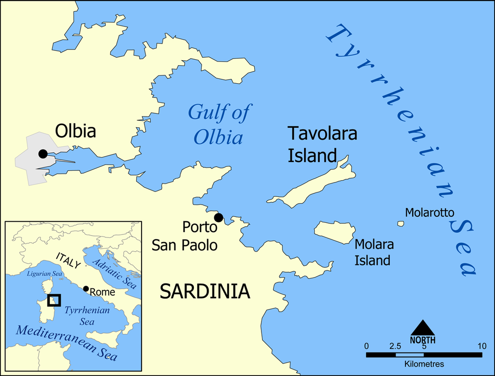
Location of Tavolara Island and Molara Island, off the coast of Sardinia, Italy.
Summary
[edit]
| Description |
This is a map showing the location of Tavolara Island and Molara Island, off the coast of Sardinia, Italy. Created by NormanEinstein, May 17, 2005. |
| Date | 17 May 2005 (original upload date) |
| Source | No machine-readable source provided. Own work assumed (based on copyright claims). |
| Author | No machine-readable author provided. NormanEinstein assumed (based on copyright claims). |
Licensing
[edit]
I, the copyright holder of this work, hereby publish it under the following licenses:

|
Permission is granted to copy, distribute and/or modify this document under the terms of the GNU Free Documentation License, Version 1.2 or any later version published by the Free Software Foundation; with no Invariant Sections, no Front-Cover Texts, and no Back-Cover Texts. A copy of the license is included in the section entitled GNU Free Documentation License. |
| This file is licensed under the Creative Commons Attribution-Share Alike 3.0 Unported license. | ||
| ||
| This licensing tag was added to this file as part of the GFDL licensing update. |
You may select the license of your choice.
File history
Click on a date/time to view the file as it appeared at that time.
| Date/Time | Thumbnail | Dimensions | User | Comment | |
|---|---|---|---|---|---|
| current | 19:02, 7 May 2007 | | 1,200 × 912 (248 KB) | NormanEinstein (talk | contribs) | Corrected typo. |
| 13:56, 19 January 2006 |  | 1,000 × 760 (267 KB) | NormanEinstein (talk | contribs) | Corrected typo. | |
| 14:17, 25 May 2005 |  | 700 × 532 (170 KB) | NormanEinstein (talk | contribs) | Added Molarotto island. | |
| 18:25, 17 May 2005 |  | 700 × 532 (165 KB) | NormanEinstein (talk | contribs) | ||
| 17:58, 17 May 2005 |  | 700 × 534 (165 KB) | NormanEinstein (talk | contribs) | This is a map showing the location of Tavolara Island and Molara Island, off the coast of Sardinia, Italy. Created by NormanEinstein, May 17, 2005. {{PD-self}} Category:Islands of Italy |
You cannot overwrite this file.
File usage on Commons
The following page uses this file:
File usage on other wikis
The following other wikis use this file:
- Usage on ar.wikipedia.org
- Usage on br.wikipedia.org
- Usage on ca.wikipedia.org
- Usage on ce.wikipedia.org
- Usage on de.wikipedia.org
- Usage on el.wikipedia.org
- Usage on en.wikipedia.org
- Usage on es.wikipedia.org
- Usage on fi.wikipedia.org
- Usage on fr.wikipedia.org
- Usage on gl.wikipedia.org
- Usage on hu.wikipedia.org
- Usage on id.wikipedia.org
- Usage on mk.wikipedia.org
- Usage on nl.wikipedia.org
- Usage on nn.wikipedia.org
- Usage on no.wikipedia.org
- Usage on pl.wikipedia.org
- Usage on pt.wikipedia.org
- Usage on ru.wikipedia.org
- Usage on sh.wikipedia.org
- Usage on sl.wikipedia.org
- Usage on sr.wikipedia.org
- Usage on ta.wikipedia.org
- Usage on th.wikipedia.org
- Usage on tr.wikipedia.org
- Usage on vi.wikipedia.org
- Usage on www.wikidata.org
View more global usage of this file.