File:Tornesch Friedrichstraße.jpg

Original file (1,024 × 640 pixels, file size: 115 KB, MIME type: image/jpeg)
Captions
Captions
Summary[edit]
| Description |
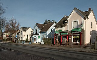
Deutsch: Tornesch (Schleswig-Holstein) - Friedrichstraße 22-28 - Bauzeit: um 1900 und folgende Jahre - Foto 2008 - Die abgebildeten Häuser entstanden alle vor dem Ersten Weltkrieg. Es sind einfache Wohnhäuser mit seitlichem Risalit, die neben den Wohnungen teilweise auch Ladengeschäfte enthalten. Ganz hinten ist das ehemalige "Blumenhaus Sonja" zu sehen (Nr. 28). Vorn sieht man das Chinarestaurant "Jasmin" (Nr. 22). Dort befand sich bis 1967 eine Filiale der Konsumgenossenschaft "Produktion". English: Tornesch (Schleswig-Holstein, Germany), Friedrichstraße 22-28 - construction period: 1900 and following years - photo 2008
- The pictured houses were all created before the First World War. They are simple residential buildings with a side risalit. Some of them contain in addition to the apartments also stores. At the far end is the former "Blumenhaus Sonja" (No. 28). In front you can see the Chinese restaurant "Jasmin" (No. 22). There was until 1967 a branch of the consumer cooperative "Produktion".
|
||||
| Date | |||||
| Source | Own work | ||||
| Author | Uwe Barghaan |
Licensing[edit]
- You are free:
- to share – to copy, distribute and transmit the work
- to remix – to adapt the work
- Under the following conditions:
- attribution – You must give appropriate credit, provide a link to the license, and indicate if changes were made. You may do so in any reasonable manner, but not in any way that suggests the licensor endorses you or your use.
- share alike – If you remix, transform, or build upon the material, you must distribute your contributions under the same or compatible license as the original.
File history
Click on a date/time to view the file as it appeared at that time.
| Date/Time | Thumbnail | Dimensions | User | Comment | |
|---|---|---|---|---|---|
| current | 17:57, 12 February 2008 | | 1,024 × 640 (115 KB) | Barghaan (talk | contribs) | {{Information |Description= |Source= |Date= |Author= |Permission= |other_versions= }} |
| 10:58, 6 February 2008 |  | 1,024 × 768 (100 KB) | Barghaan (talk | contribs) | {{InformationHof "An der Pinnau" |Description={{de| Tornesch (Schleswig-Holstein), Friedrichstraße , Foto 2008 }} {{en| Tornesch (Slesvic-Holstein, Germany), Friedrichstraße, photo 2008 }} |Source=own work |Date=2008-02-06 |Author=[[:de:Benutzer:Bargh |
You cannot overwrite this file.
File usage on Commons
The following 2 pages use this file:
File usage on other wikis
The following other wikis use this file:
- Usage on ar.wikipedia.org
- Usage on azb.wikipedia.org
- Usage on ceb.wikipedia.org
- Usage on ce.wikipedia.org
- Usage on da.wikipedia.org
- Usage on de.wikipedia.org
- Usage on diq.wikipedia.org
- Usage on es.wikipedia.org
- Usage on eu.wikipedia.org
- Usage on fr.wikipedia.org
- Usage on hu.wikipedia.org
- Usage on it.wikipedia.org
- Usage on ku.wikipedia.org
- Usage on ky.wikipedia.org
- Usage on lld.wikipedia.org
- Usage on pl.wikipedia.org
- Usage on ro.wikipedia.org
- Usage on ru.wikipedia.org
- Usage on sr.wikipedia.org
- Usage on tt.wikipedia.org
- Usage on uz.wikipedia.org
- Usage on vi.wikipedia.org
- Usage on www.wikidata.org