File:Tribal Territories Southern New England.png
Jump to navigation
Jump to search
Size of this preview: 800 × 550 pixels. Other resolutions: 320 × 220 pixels | 640 × 440 pixels | 1,024 × 704 pixels | 1,280 × 880 pixels | 1,701 × 1,169 pixels.
Original file (1,701 × 1,169 pixels, file size: 490 KB, MIME type: image/png)
Captions
Captions
Add a one-line explanation of what this file represents

|
This map image could be re-created using vector graphics as an SVG file. This has several advantages; see Commons:Media for cleanup for more information. If an SVG form of this image is available, please upload it and afterwards replace this template with
{{vector version available|new image name}}.
It is recommended to name the SVG file “Tribal Territories Southern New England.svg”—then the template Vector version available (or Vva) does not need the new image name parameter. |
Summary[edit]
| Description |
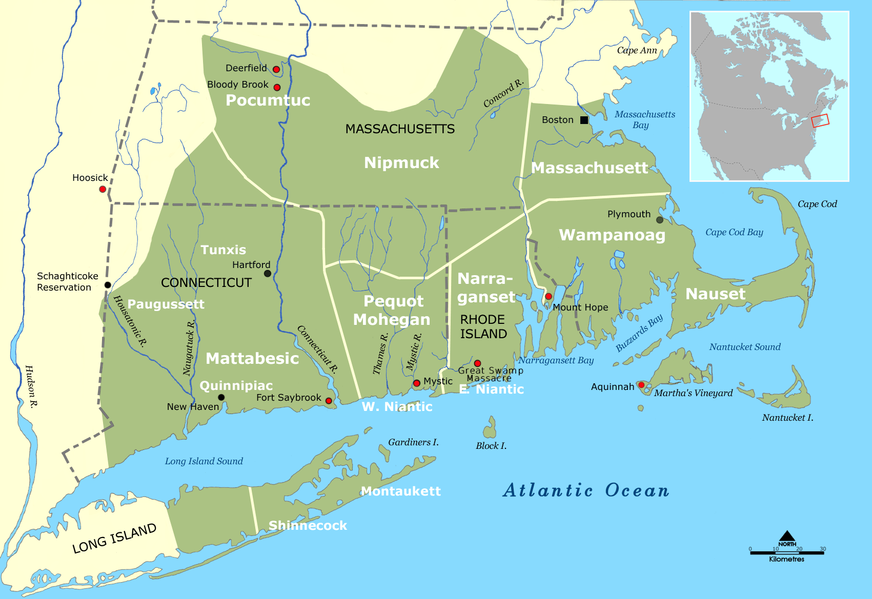
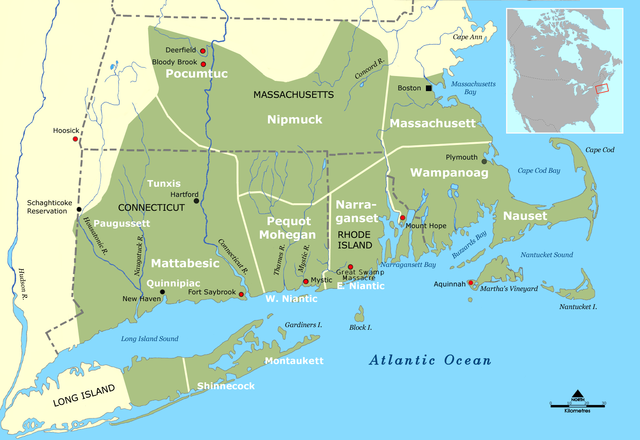
English: Tribal territories of Southern New England tribes about 1600. Grey dotted lines are approximate modern political boundaries. |
| Date | |
| Source | Wikimedia Commons - Image:Wohngebiet_Südneuengland.png, as of 5 July 2006 |
| Author | Nikater; adapted to English by Hydrargyrum |
| Other versions |
 |
Licensing[edit]
I, the copyright holder of this work, hereby publish it under the following licenses:
This file is licensed under the Creative Commons Attribution-Share Alike 3.0 Unported license.
- You are free:
- to share – to copy, distribute and transmit the work
- to remix – to adapt the work
- Under the following conditions:
- attribution – You must give appropriate credit, provide a link to the license, and indicate if changes were made. You may do so in any reasonable manner, but not in any way that suggests the licensor endorses you or your use.
- share alike – If you remix, transform, or build upon the material, you must distribute your contributions under the same or compatible license as the original.

|
Permission is granted to copy, distribute and/or modify this document under the terms of the GNU Free Documentation License, Version 1.2 or any later version published by the Free Software Foundation; with no Invariant Sections, no Front-Cover Texts, and no Back-Cover Texts. A copy of the license is included in the section entitled GNU Free Documentation License. |
You may select the license of your choice.
File history
Click on a date/time to view the file as it appeared at that time.
| Date/Time | Thumbnail | Dimensions | User | Comment | |
|---|---|---|---|---|---|
| current | 05:21, 25 November 2008 | | 1,701 × 1,169 (490 KB) | Hydrargyrum (talk | contribs) | Changed "Montauk" to "Montaukett" |
| 04:53, 25 November 2008 |  | 1,701 × 1,169 (490 KB) | Hydrargyrum (talk | contribs) | {{Information |Description={{en|1=Tribal territories of Southern New England tribes about 1600}} |Source=Wikimedia Commons - Image:Wohngebiet_Südneuengland.png, as of 5 July 2006 |Author=Nikater; adapted to English by [[User:Hydrarg |
You cannot overwrite this file.
File usage on Commons
There are no pages that use this file.
File usage on other wikis
The following other wikis use this file:
- Usage on ar.wikipedia.org
- Usage on arz.wikipedia.org
- Usage on bg.wikipedia.org
- Usage on ca.wikipedia.org
- Usage on cs.wikipedia.org
- Usage on de.wikipedia.org
- Usage on en.wikipedia.org
- Long Island
- Massachusetts Bay Colony
- Narragansett people
- Quinnipiac
- Quiripi language
- Massachusett language
- East Hampton, New York
- Niantic people
- Massachusett
- Raid on Deerfield
- Nauset
- Nipmuc
- Pocomtuc
- History of Massachusetts
- History of Rhode Island
- Montaukett
- Wyandanch (sachem)
- Shinnecock Indian Nation
- Thomas Dermer
- History of Long Island
- Metoac
- Mohegan-Pequot language
- Patuxet
- New England
- Native American tribes in Massachusetts
- Narragansett language
- Humphrey Atherton
- Narragansett land claim
- Battle of Bloody Brook
- Portal:New England
- User:Ishtar456/Sandbox2
- User:Joelton Ivson/Gather lists/24319 – Indígenas América do Norte
View more global usage of this file.
Categories:
- English-language maps showing history
- Maps of Native American tribal territories
- Maps of New England
- Massachusett (tribe)
- Mattabesset
- Mohegan
- Narragansett tribe
- Nauset people
- Niantic people
- Nipmuc maps
- Pequot maps
- Wampanoag maps
- History of indigenous peoples of New England
- Maps of the history of Massachusetts
- Maps of the history of Rhode Island
- Maps of the history of Connecticut
- Golden Hill Paugussett Indian Nation
- Tunxis
- Pocomtuc