File:U-Bahn-Netz Wien 2019.png
Jump to navigation
Jump to search

Size of this preview: 800 × 511 pixels. Other resolutions: 320 × 204 pixels | 640 × 409 pixels | 1,024 × 654 pixels | 1,280 × 818 pixels | 2,326 × 1,486 pixels.
Original file (2,326 × 1,486 pixels, file size: 260 KB, MIME type: image/png)
Captions
Captions
Add a one-line explanation of what this file represents
| Description |
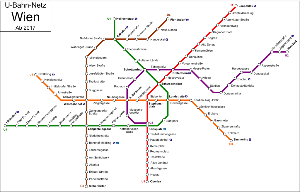
Deutsch: Netzplan Wiener U-Bahn 2017
Esperanto: Retmapo de la viena metroo en 2017 |
||||||||
| Date | |||||||||
| Source | Own work | ||||||||
| Author | User:My Friend | ||||||||
| Permission (Reusing this file) |
I, the copyright holder of this work, hereby publish it under the following licenses:
You may select the license of your choice. |


|
This transport map image could be re-created using vector graphics as an SVG file. This has several advantages; see Commons:Media for cleanup for more information. If an SVG form of this image is available, please upload it and afterwards replace this template with
{{vector version available|new image name}}.
It is recommended to name the SVG file “U-Bahn-Netz Wien 2019.svg”—then the template Vector version available (or Vva) does not need the new image name parameter. |
File history
Click on a date/time to view the file as it appeared at that time.
| Date/Time | Thumbnail | Dimensions | User | Comment | |
|---|---|---|---|---|---|
| current | 08:56, 28 August 2013 | | 2,326 × 1,486 (260 KB) | My Friend (talk | contribs) | Aspern > Aspern Nord |
| 14:06, 26 September 2012 |  | 2,326 × 1,484 (259 KB) | My Friend (talk | contribs) | {{Information |Description= |Source= |Date= |Author= |Permission= |other_versions= }} | |
| 17:40, 27 March 2012 |  | 2,326 × 1,484 (262 KB) | My Friend (talk | contribs) | oops | |
| 17:38, 27 March 2012 |  | 2,326 × 1,636 (276 KB) | My Friend (talk | contribs) | aktualisiert | |
| 19:40, 7 November 2010 |  | 2,326 × 1,484 (275 KB) | My Friend (talk | contribs) | korrektur reihenfolge rennweg, st marx | |
| 18:54, 2 October 2010 |  | 2,326 × 1,484 (275 KB) | My Friend (talk | contribs) | -hausfeldstraße S-Bahn ?an den alten schanzen | |
| 18:14, 17 September 2010 |  | 2,326 × 1,484 (275 KB) | My Friend (talk | contribs) | S-Bahn-Symbol bei Handelskai, Rennweg, St. Marx | |
| 17:34, 17 September 2010 |  | 2,326 × 1,484 (273 KB) | My Friend (talk | contribs) | aktualisiert | |
| 11:13, 7 July 2009 |  | 2,248 × 1,519 (287 KB) | My Friend (talk | contribs) | {{Information |Description={{de|1=Netzplan Wiener U-Bahn 2019}} |Source=own work |Date=2009-07-07 |Author=User:My Friend |Permission={{GFDL-self}} |other_versions= }} Category:Public transport maps of VOR <!--{{ImageUpload|basic}}--> |
You cannot overwrite this file.
File usage on Commons
The following page uses this file:
File usage on other wikis
The following other wikis use this file:
- Usage on af.wikipedia.org
- Usage on de.wikipedia.org
- Usage on en.wikipedia.org
- Usage on fr.wikivoyage.org
- Usage on hu.wikipedia.org
- Usage on id.wikipedia.org
- Usage on it.wikivoyage.org
- Usage on ja.wikipedia.org
- Usage on pl.wikipedia.org