File:U-Bahn Wien, Netzplan.svg
Jump to navigation
Jump to search

Size of this PNG preview of this SVG file: 637 × 600 pixels. Other resolutions: 255 × 240 pixels | 510 × 480 pixels | 816 × 768 pixels | 1,088 × 1,024 pixels | 2,176 × 2,048 pixels | 835 × 786 pixels.
Original file (SVG file, nominally 835 × 786 pixels, file size: 152 KB)
Captions
Captions
Add a one-line explanation of what this file represents
Summary[edit]
| Description |
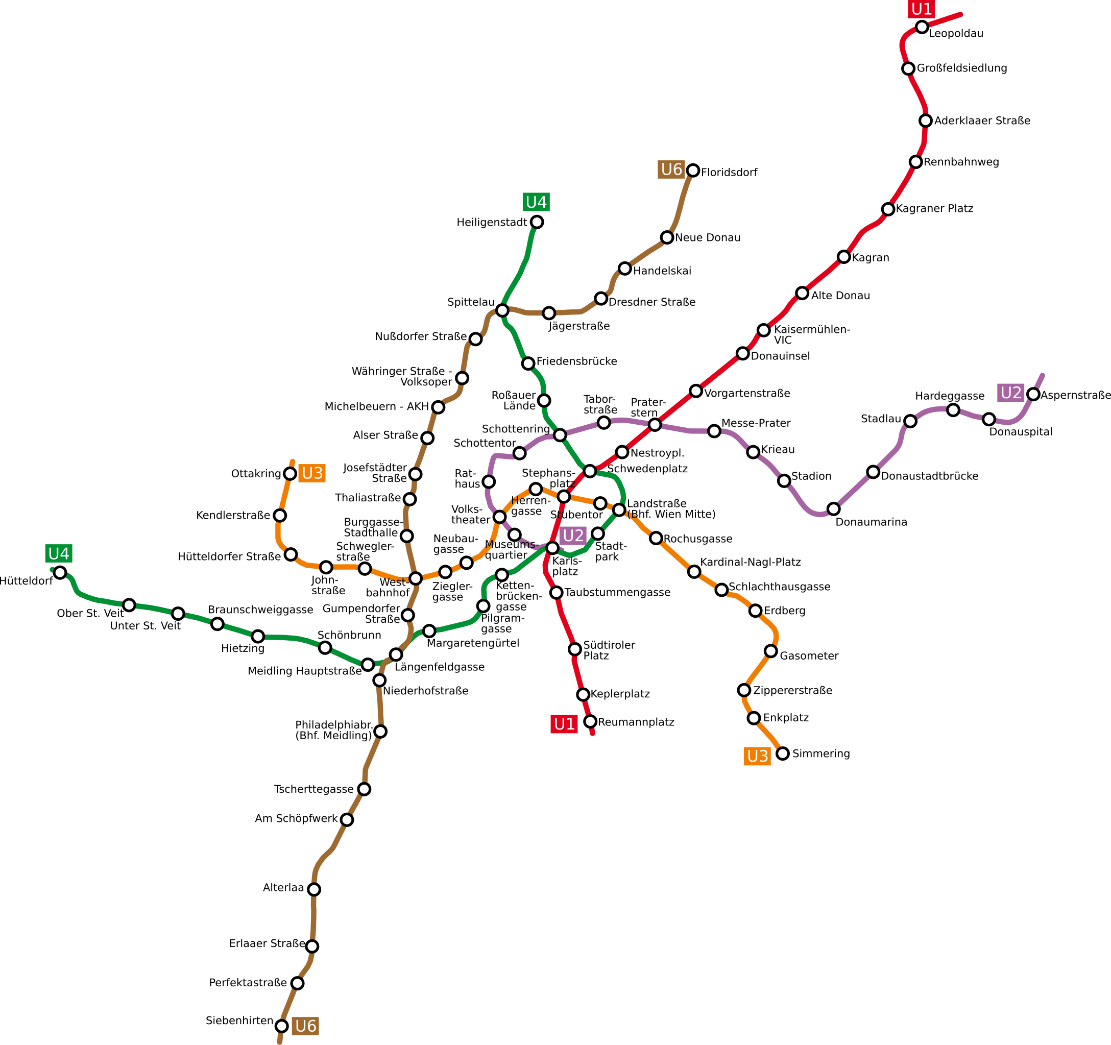
Deutsch: Netzplan der Wiener U-Bahn
English: The underground network of the Austrian capital Vienna
Esperanto: La metroreto de la Aŭstruja ĉefurbo Vieno
Polski: Plan wiedeńskiego metra |
| Date | |
| Source | http://www.openstreetmap.org/browse/relation/27116 |
| Author | OpenStreetMap contributors, Ircecho |
| SVG development |
Licensing[edit]
I, the copyright holder of this work, hereby publish it under the following license:
This file is licensed under the Creative Commons Attribution-Share Alike 2.0 Generic license.
- You are free:
- to share – to copy, distribute and transmit the work
- to remix – to adapt the work
- Under the following conditions:
- attribution – You must give appropriate credit, provide a link to the license, and indicate if changes were made. You may do so in any reasonable manner, but not in any way that suggests the licensor endorses you or your use.
- share alike – If you remix, transform, or build upon the material, you must distribute your contributions under the same or compatible license as the original.
File history
Click on a date/time to view the file as it appeared at that time.
| Date/Time | Thumbnail | Dimensions | User | Comment | |
|---|---|---|---|---|---|
| current | 15:07, 12 April 2011 | | 835 × 786 (152 KB) | Ircecho (talk | contribs) | I now improved readability. Additionally i removed the city border as to make the update just an update. As based on my research i think the old plan is incorrect, its in my opinion right to overwrite it with this redo. |
| 14:30, 8 April 2011 |  | 1,063 × 1,020 (136 KB) | Invisigoth67 (talk | contribs) | Reverted to version as of 18:54, 30 March 2011: Please do not overwrite with a complete new plan, use an new filename instead. This version is much better readable than the new layout. | |
| 18:28, 4 April 2011 |  | 1,488 × 1,052 (271 KB) | Ircecho (talk | contribs) | Redid the whole plan. | |
| 18:54, 30 March 2011 |  | 1,063 × 1,020 (136 KB) | Ircecho (talk | contribs) | Extended the map to include the expansion state of 2011. Track and station positions are based on openstreetmap data, which was aligned to stations Donauinsel, Vorgartenstrasse, Krieau, Kardinal-Nagl-Platz and Schlachthausgasse. Stadion was moved a bit, f | |
| 17:44, 11 May 2008 |  | 982 × 1,031 (132 KB) | Aldaron (talk | contribs) | == Summary == {{Information |Description=*de: Netzplan der Wiener U-Bahn *en: The underground network of the Austrian capital Vienna |Source= |Date=2007 |Author=Based on original upload by L.m.k |Permission= |other_versions= }} | |
| 11:19, 13 March 2007 |  | 982 × 1,031 (127 KB) | Hukkepakk (talk | contribs) | == Summary == {{Information |Description=*[:de:]] Netzplan der Wiener U-Bahn *en: The underground network of the Austrian capital Vienna.}} |Source= |Date=2007 |Author=L.m.k |Permission= |other_versions= }} == Licensing == {{self2|GFD |
You cannot overwrite this file.
File usage on Commons
There are no pages that use this file.
File usage on other wikis
The following other wikis use this file:
- Usage on ca.wikipedia.org
- Usage on da.wikipedia.org
- Usage on de.wikipedia.org
- Usage on eo.wikipedia.org
- Usage on ro.wikipedia.org
- Usage on ru.wikivoyage.org
- Usage on sk.wikipedia.org