File:USA 2008 unemployment by county.svg
Jump to navigation
Jump to search

Size of this PNG preview of this SVG file: 555 × 352 pixels. Other resolutions: 320 × 203 pixels | 640 × 406 pixels | 1,024 × 649 pixels | 1,280 × 812 pixels | 2,560 × 1,624 pixels.
Original file (SVG file, nominally 555 × 352 pixels, file size: 1.37 MB)
Captions
Captions
Add a one-line explanation of what this file represents
| Description |
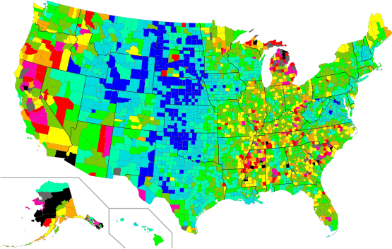
English: U.S. map with counties labeled by FIPS code according to the average 2008 unemployment rate at the Bureau of Labor Statistics.[1]
1.2–3%
3.1–4%
4.1–5%
5.1–6%
6.1–7%
7.1–8%
8.1–9%
9.1–10%
10.1–11%
11.1–13%
13.1–22.9% |
| Date | (UTC) |
| Source | |
| Author |
|
| Other versions |
Derivative works of this file: |
I, the copyright holder of this work, hereby publish it under the following licenses:
This file is licensed under the Creative Commons Attribution-Share Alike 3.0 Unported license.
- You are free:
- to share – to copy, distribute and transmit the work
- to remix – to adapt the work
- Under the following conditions:
- attribution – You must give appropriate credit, provide a link to the license, and indicate if changes were made. You may do so in any reasonable manner, but not in any way that suggests the licensor endorses you or your use.
- share alike – If you remix, transform, or build upon the material, you must distribute your contributions under the same or compatible license as the original.

|
Permission is granted to copy, distribute and/or modify this document under the terms of the GNU Free Documentation License, Version 1.2 or any later version published by the Free Software Foundation; with no Invariant Sections, no Front-Cover Texts, and no Back-Cover Texts. A copy of the license is included in the section entitled GNU Free Documentation License. |
You may select the license of your choice.
Original upload log
[edit]
This image is a derivative work of the following images:
- File:USA_counties_FIPS_text_addressable.svg licensed with Cc-by-sa-3.0, GFDL
- 2009-05-20T01:50:12Z Mike Serfas 555x352 (1410294 Bytes) {{Information |Description={{en|1=Blank U.S. map with counties labeled by FIPS code. These can be colored by editing the document as text and adding FIPS codes, followed by a fill color for each group. This file is based on
Uploaded with derivativeFX
File history
Click on a date/time to view the file as it appeared at that time.
| Date/Time | Thumbnail | Dimensions | User | Comment | |
|---|---|---|---|---|---|
| current | 02:35, 20 May 2009 | | 555 × 352 (1.37 MB) | Mike Serfas (talk | contribs) | The previous version had two colors that were too similar. |
| 02:03, 20 May 2009 |  | 555 × 352 (1.37 MB) | Mike Serfas (talk | contribs) | The preceding version uses a color scheme which to me appears to minimize unemployment, while this one appears to maximize the problem. I am amazed how much of a difference the color scheme makes in the subjective feeling produced by the data --- and ''t | |
| 01:58, 20 May 2009 |  | 555 × 352 (1.37 MB) | Mike Serfas (talk | contribs) | {{Information |Description={{en|1=U.S. map with counties labeled by FIPS code according to the average 2008 unemployment rate at the Bureau of Labor Statistics.[ftp://ftp.bls.gov/pub/special.requests/la/laucnty08.txt]}} |Source=*[[:File:USA_counties_FIPS_ |
You cannot overwrite this file.
File usage on Commons
The following page uses this file:
File usage on other wikis
The following other wikis use this file:
- Usage on en.wikipedia.org
- Usage on kn.wikipedia.org
- Usage on mk.wikipedia.org
- Usage on ta.wikipedia.org
- Usage on ta.wiktionary.org