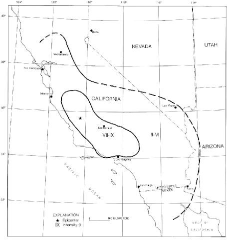
File:USGS isoseismal map - 1857 Fort Tejon earthquake.gif
קפיצה לניווט
קפיצה לחיפוש

גודל התצוגה המקדימה הזאת: 568 × 600 פיקסלים. רזולוציות אחרות: 227 × 240 פיקסלים | 455 × 480 פיקסלים | 649 × 685 פיקסלים.
לקובץ המקורי (649 × 685 פיקסלים, גודל הקובץ: 33 ק"ב, סוג MIME: image/gif)
כיתובים
כיתובים
נא להוסיף משפט שמסביר מה הקובץ מייצג
תקציר[עריכה]
| תיאור | |
| תאריך יצירה | |
| מקור | The Great M7.9 1857 Fort Tejon Earthquake |
| יוצר | United States Geological Survey |
רישיון[עריכה]
This image is in the public domain in the United States because it only contains materials that originally came from the United States Geological Survey, an agency of the United States Department of the Interior. For more information, see the official USGS copyright policy.
|
היסטוריית הקובץ
ניתן ללחוץ על תאריך/שעה כדי לראות את הקובץ כפי שנראה באותו זמן.
| תאריך/שעה | תמונה ממוזערת | ממדים | משתמש | הערה | |
|---|---|---|---|---|---|
| נוכחית | 21:11, 9 בינואר 2017 | | 685 × 649 (33 ק"ב) | Dawnseeker2000 (שיחה | תרומות) | User created page with UploadWizard |
אין באפשרותך לדרוס את הקובץ הזה.
שימוש בקובץ
אין דפים המשתמשים בקובץ זה.
שימוש גלובלי בקובץ
אתרי הוויקי השונים הבאים משתמשים בקובץ זה:
- שימוש באתר en.wikipedia.org
- שימוש באתר es.wikipedia.org
- שימוש באתר he.wikipedia.org