Category:Maps of earthquakes in California
Jump to navigation
Jump to search
States of the United States: Alabama · Alaska · Arkansas · California · Hawaii · Idaho · Illinois · Indiana · Nevada · Oklahoma · Oregon
Northern Mariana Islands · Puerto Rico
Northern Mariana Islands · Puerto Rico
English: Maps of earthquakes in California.
Subcategories
This category has the following 2 subcategories, out of 2 total.
Media in category "Maps of earthquakes in California"
The following 69 files are in this category, out of 69 total.
-

-
 1983californiamap.png 179 × 181; 24 KB
-
 1989 Loma Prieta Shake Map.jpg 437 × 647; 69 KB
-
 Parkfield earthquake activity map.gif 568 × 637; 47 KB
-
 2007 alum rock earthquake map.jpg 498 × 584; 60 KB
-
 2019-07-04 Searles Valley, CA M6.4 earthquake intensity map (USGS).jpg 612 × 684; 111 KB
-
 2019-07-04 Searles Valley, CA M6.4 earthquake shakemap (USGS).jpg 867 × 1,070; 451 KB
-
 2019-07-06 Ridgecrest, CA M7.1 earthquake intensity map (USGS).jpg 612 × 684; 106 KB
-
 2019-07-06 Ridgecrest, CA M7.1 earthquake shakemap (ci).jpg 612 × 792; 328 KB
-
 2019-07-06 Ridgecrest, CA M7.1 earthquake shakemap (USGS).jpg 869 × 1,079; 464 KB
-
 2019-07-06 Searles Valley, CA M7.1 earthquake intensity map (USGS).jpg 612 × 684; 106 KB
-
 2019-07-06 Searles Valley, CA M7.1 earthquake shakemap (cgs).jpg 612 × 792; 169 KB
-
 2019-07-06 Searles Valley, CA M7.1 earthquake shakemap (ci).jpg 612 × 792; 278 KB
-
 2019-07-06 Searles Valley, CA M7.1 earthquake shakemap (USGS).jpg 832 × 1,068; 447 KB
-
 2021-07-08 Antelope Valley, CA M6 earthquake intensity map (USGS).jpg 612 × 684; 174 KB
-
 2021-07-08 Antelope Valley, CA M6 earthquake shakemap (cgs).jpg 846 × 1,065; 511 KB
-
 2021-07-08 Antelope Valley, CA M6 earthquake shakemap (nc).jpg 787 × 1,004; 447 KB
-
 2021-07-08 Antelope Valley, CA M6 earthquake shakemap (USGS).jpg 787 × 1,000; 415 KB
-
 2021-07-08 Markleeville, CA M6 earthquake intensity map (USGS).jpg 612 × 684; 154 KB
-
 2021-07-08 Markleeville, CA M6 earthquake shakemap (cgs).jpg 844 × 1,069; 492 KB
-
 2021-07-08 Markleeville, CA M6 earthquake shakemap (nc).jpg 787 × 1,004; 435 KB
-
 2021-07-08 Markleeville, CA M6 earthquake shakemap (USGS).jpg 819 × 1,002; 325 KB
-
 2021-12-20 Petrolia, CA M6.2 earthquake intensity map (USGS).jpg 612 × 684; 130 KB
-
 2021-12-20 Petrolia, CA M6.2 earthquake shakemap (cgs).jpg 612 × 660; 91 KB
-
 2021-12-20 Petrolia, CA M6.2 earthquake shakemap (nc).jpg 787 × 1,003; 301 KB
-
 2021-12-20 Petrolia, CA M6.2 earthquake shakemap (USGS).jpg 791 × 1,001; 261 KB
-
 2021-12-21 Petrolia, CA M6.2 earthquake intensity map (USGS).jpg 612 × 684; 133 KB
-
 2021-12-21 Petrolia, CA M6.2 earthquake shakemap (cgs).jpg 612 × 660; 98 KB
-
 2021-12-21 Petrolia, CA M6.2 earthquake shakemap (nc).jpg 787 × 1,003; 318 KB
-
 2022-12-20 Ferndale, CA M6.37 earthquake intensity map (USGS).jpg 612 × 684; 113 KB
-
 2022-12-20 Ferndale, CA M6.37 earthquake shakemap (cgs).jpg 840 × 1,067; 330 KB
-
 2022-12-20 Ferndale, CA M6.37 earthquake shakemap (nc).jpg 792 × 1,003; 301 KB
-
 2022-12-20 Ferndale, CA M6.37 earthquake shakemap (USGS).jpg 788 × 1,005; 135 KB
-
 2022-12-20 Ferndale, CA M6.4 earthquake intensity map (USGS).jpg 612 × 684; 136 KB
-
 2022-12-20 Ferndale, CA M6.4 earthquake shakemap (cgs).jpg 833 × 1,051; 329 KB
-
 2022-12-20 Ferndale, CA M6.4 earthquake shakemap (nc).jpg 787 × 992; 310 KB
-
 2022-12-20 Ferndale, CA M6.4 earthquake shakemap (USGS).jpg 788 × 986; 144 KB
-
 5.6 california quake Oct 30 2007.png 612 × 684; 64 KB
-
 5.6 san jose quake Oct 30 2007 40204628.gif 612 × 684; 32 KB
-
 Aerial map of the Northridge earthquake.jpg 300 × 226; 21 KB
-
 CA ShakeOut Map.pdf 1,137 × 931; 996 KB
-
 California Department of Conservation - Earthquake Shaking Potential for California.jpg 5,000 × 7,400; 3.56 MB
-

-
 California Department of Conservation – Earthquake Shaking Potential for California.jpg 1,705 × 2,144; 951 KB
-
 California quake Oct 16 2007.jpg 488 × 551; 72 KB
-
 San Gabiel fault.jpg 214 × 218; 61 KB
-
 USGS - San Jacinto Fault Zone.gif 214 × 218; 16 KB
-
 USGS - Sierra Madre Fault Zone.gif 214 × 218; 17 KB
-
 USGS map of Imperial fault zone.gif 214 × 218; 16 KB
-
 Ferndale Eureka RegionHistoricSeismicity.jpg 496 × 590; 355 KB
-
 Hector-Mine-earthquake-1999-Oct-16-USGS-map.jpg 461 × 548; 74 KB
-
 Juan-de-fuca-plate.PNG 536 × 652; 46 KB
-
 LomaPrieta ShakeMap.png 775 × 949; 1.27 MB
-
 2010 Southern California Earthquake Storm.PNG 500 × 461; 74 KB
-
 MexicaliEarthquakeSwarm.gif 543 × 532; 13 KB
-
 NorthHaywardShake.gif 640 × 440; 21 KB
-
 San Andreas Fault Oldham 1909 2.png 1,467 × 2,561; 1.8 MB
-
 Santa Rosa 1969 earthquake locations.png 628 × 405; 382 KB
-
 Santa Rosa Geological Structure.png 1,214 × 749; 958 KB
-
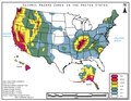 Seismic Hazard Zones in the United States..pdf 1,650 × 1,275; 460 KB
-
 Shake Map of the 5.1 in Ojai.jpg 804 × 1,003; 168 KB
-
 SouthHaywardShake.gif 640 × 440; 22 KB
-
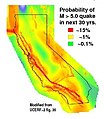 UCERF participation map.jpg 336 × 386; 28 KB
-
 USGS - 1971 San Fernando earthquake - Isoseismal map.gif 658 × 557; 44 KB
-
 USGS - Newport-Inglewood-Rose Canyon fault zone.gif 214 × 218; 16 KB
-
 USGS - San Andreas fault zone.gif 214 × 218; 17 KB
-
 USGS isoseismal map - 1857 Fort Tejon earthquake.gif 649 × 685; 33 KB
-
 USGS-EQBeta-map-example.tiff 1,398 × 1,012; 2.12 MB
-
 USGS-EQBeta-SFO-search example.tiff 359 × 572; 92 KB


.jpg)
.jpg)
.jpg)
.jpg)
.jpg)
.jpg)
.jpg)
.jpg)
.jpg)
.jpg)
.jpg)
.jpg)
.jpg)
.jpg)
.jpg)
.jpg)
.jpg)
.jpg)
.jpg)
.jpg)
.jpg)
.jpg)
.jpg)
.jpg)
.jpg)
.jpg)
.jpg)
.jpg)
.jpg)
.jpg)
.jpg)
.jpg)


.gif)


