File:Völkerkarte von Mittel- und Südosteuropa. Italien 1815 bis zur Gegenwart (1905).jpg

File originale (1 574 × 1 886 pixel, dimensione del file: 600 KB, tipo MIME: image/jpeg)
Didascalie
Didascalie
Dettagli[modifica]
.jpg&action=edit§ion=1)
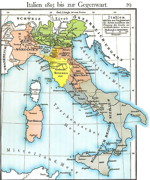
| Descrizione | Cartina dell'unificazione d'Italia dal 1815 fino al 1870 (il ducato di Massa e Carrara, ufficialmente indipendente fino al 1829, non è però indicato, e, non correttamente, è già considerato parte del ducato di Modena fin dal 1815) |
| Data | |
| Fonte | Historischer Schulatlas di F. W Putzger (1814--1913) Plate 29 from F. W. Putzgers Historischer Schul-Atlas |
| Autore | F. W Putzger (1814--1913) |
| Altre versioni | File:Italy unification 1815 1870.jpg |
derivative works[modifica]
.jpg&action=edit§ion=2)
Opere derivate da questo file: Italy1816cs.png Putzger, Historischer Schul-Atlas di F. W Putzger (1814--1913).
Licenza[modifica]
.jpg&action=edit§ion=3)
|
Quest'opera è nel pubblico dominio anche in tutti i Paesi e nelle aree in cui la durata del copyright è la vita dell'autore più 70 anni o meno.
| |
| Questo file è stato identificato come libero da restrizioni conosciute riguardanti le leggi sul copyright, compresi tutti i diritti connessi e vicini. | |
Cronologia del file
Fare clic su un gruppo data/ora per vedere il file come si presentava nel momento indicato.
| Data/Ora | Miniatura | Dimensioni | Utente | Commento | |
|---|---|---|---|---|---|
| attuale | 12:40, 19 mar 2011 | | 1 574 × 1 886 (600 KB) | A7N8X (discussione | contributi) | cleared from the watermark image, improved compression. jpeg, making it progressively improving and quick viewing |
| 15:33, 22 gen 2009 |  | 1 640 × 1 971 (1 007 KB) | MegaMatic (discussione | contributi) | {{PD-old}} | |
| 11:34, 23 mag 2006 |  | 1 640 × 1 971 (1,05 MB) | Massimo Macconi (discussione | contributi) | Cartina dell'Italia nel 1815 tratta da Historisches Schulatlas di F. W Putzgers (1814--1913) |
Impossibile sovrascrivere questo file.
Utilizzo del file
Le seguenti 5 pagine usano questo file:
- Atlas of Italy
- File:Emilia Occidentale 1815.jpg
- File:Italia1815.jpg (reindirizzamento file)
Utilizzo globale del file
Anche i seguenti wiki usano questo file:
- Usato nelle seguenti pagine di af.wikipedia.org:
- Usato nelle seguenti pagine di als.wikipedia.org:
- Usato nelle seguenti pagine di ast.wikipedia.org:
- Usato nelle seguenti pagine di br.wikipedia.org:
- Usato nelle seguenti pagine di ca.wikipedia.org:
- Usato nelle seguenti pagine di de.wikipedia.org:
- Usato nelle seguenti pagine di en.wikipedia.org:
- Usato nelle seguenti pagine di fr.wikipedia.org:
- Usato nelle seguenti pagine di hu.wikipedia.org:
- Usato nelle seguenti pagine di it.wikipedia.org:
- Usato nelle seguenti pagine di la.wikipedia.org:
- Usato nelle seguenti pagine di nl.wikipedia.org:
- Usato nelle seguenti pagine di pl.wikipedia.org:
- Usato nelle seguenti pagine di scn.wikipedia.org:
- Usato nelle seguenti pagine di sk.wikipedia.org:
- Usato nelle seguenti pagine di vec.wikipedia.org:
- Usato nelle seguenti pagine di www.wikidata.org:
Metadati
.jpg&oldid=864363844)
- Putzgers Historischer Schul-Atlas
- Maps of Italian Risorgimento
- Old Maps of the Italian Peninsula in History
- 1815 in Italy
- 1870
- Kingdom of Sardinia
- Maps of the history of Sardinia
- Maps of the Kingdom of the Two Sicilies
- Maps of the Kingdom of Lombardy-Venetia
- Maps of the Duchy of Parma and Piacenza
- Maps of Duchy of Modena and Reggio
- Maps of the Grand Duchy of Tuscany
- Maps of the Papal States
- Papal States in the 19th century