File:Vignemale.jpg
Jump to navigation
Jump to search
No higher resolution available.
Vignemale.jpg (539 × 349 pixels, file size: 60 KB, MIME type: image/jpeg)
Captions
Captions
Add a one-line explanation of what this file represents
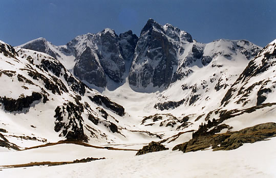
Le Vignemale est situé à la frontière franco-espagnole. Avec ses 3 298 m, il est le plus haut sommet des Pyrénées françaises. Il est accessible depuis Gavarnie ou Cauterets en plein centre des Pyrénées. Sa célèbre face Nord parcourue par le couloir de Gaube est imposante et peut être observée depuis le refuge des Oulettes de Gaube.
This file is licensed under the Creative Commons Attribution-Share Alike 2.0 France license.
- You are free:
- to share – to copy, distribute and transmit the work
- to remix – to adapt the work
- Under the following conditions:
- attribution – You must give appropriate credit, provide a link to the license, and indicate if changes were made. You may do so in any reasonable manner, but not in any way that suggests the licensor endorses you or your use.
- share alike – If you remix, transform, or build upon the material, you must distribute your contributions under the same or compatible license as the original.

File history
Click on a date/time to view the file as it appeared at that time.
| Date/Time | Thumbnail | Dimensions | User | Comment | |
|---|---|---|---|---|---|
| current | 23:31, 20 April 2005 | | 539 × 349 (60 KB) | Rokad~commonswiki (talk | contribs) | Le Vignemale est situé à la frontière franco-espagnole. Avec ses 3 298 m, il est le plus haut sommet des Pyrénées françaises. Il est accessible depuis Gavarnie ou Cauterets en plein centre des Pyrénées. Sa célèbre face Nord parcourue par le coul |
You cannot overwrite this file.
File usage on Commons
The following 2 pages use this file:
File usage on other wikis
The following other wikis use this file:
- Usage on an.wikipedia.org
- Usage on ca.wikipedia.org
- Usage on cs.wikipedia.org
- Usage on en.wikipedia.org
- Usage on es.wikipedia.org
- Usage on fr.wikipedia.org
- Usage on ja.wikipedia.org
- Usage on nl.wikipedia.org
- Usage on nn.wikipedia.org
- Usage on pl.wikipedia.org
- Usage on ro.wikipedia.org
- Usage on ru.wikipedia.org
- Usage on zh.wikipedia.org