File:Volcanoes of Western Isabela.jpg
Vai alla navigazione
Vai alla ricerca
Non sono disponibili versioni a risoluzione più elevata.
Volcanoes_of_Western_Isabela.jpg (631 × 480 pixel, dimensione del file: 99 KB, tipo MIME: image/jpeg)
Didascalie
Didascalie
Aggiungi una brevissima spiegazione di ciò che questo file rappresenta
Dettagli
[modifica]| Descrizione |
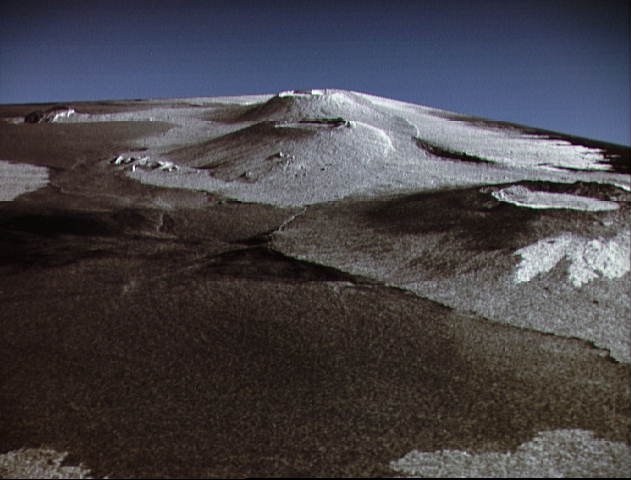
English: This is a three dimensional perspective view of Isla Isabela in the western Galapagos Islands. It was taken by the L-band radar in HH polarization from the Spaceborne Imaging Radar-C/X-Band Synthetic Aperature Radar on the 40th orbit of the Shuttle Endeavour. This view was constructed by overlaying a SIR-C radar image on a U.S. Geological Survey digital elevation map. The image is centered at about .5 degrees south latitude and 91 degrees West longitude and covers an area of 75 km by 60 km. This SIR-C/X-SAR image of Alcedo and Sierra Negra volcanoes shows the rougher lava flows as bright features, while ash deposits and smooth Pahoehoe lava flows dark. The Jet Propulsion Laboratory alternative photo number is P-43938. |
| Data | |
| Fonte | www.nasaimages.org |
| Autore | NASA (Space Shuttle Endeavour) |
| Altre versioni |
|


.jpg)
.jpg)
| Luogo dello scatto | | Posizione di questa e altre immagini su: OpenStreetMap |
|---|
| Posizione del soggetto | | Posizione di questa e altre immagini su: OpenStreetMap |
|---|
Licenza
[modifica]
| Questo file è nel pubblico dominio perché creato dalla NASA. La politica sul copyright della NASA afferma che «il materiale della NASA non è protetto da copyright a meno che non sia specificato altrimenti». (NASA copyright policy e JPL Image Use Policy). | ||
 |
Attenzione:
|
Cronologia del file
Fare clic su un gruppo data/ora per vedere il file come si presentava nel momento indicato.
| Data/Ora | Miniatura | Dimensioni | Utente | Commento | |
|---|---|---|---|---|---|
| attuale | 21:36, 4 mag 2010 | | 631 × 480 (99 KB) | Dr Brains (discussione | contributi) | {{Information |Description={{en|1=This is a three dimensional perspective view of Isla Isabela in the western Galapagos Islands. It was taken by the L-band radar in HH polarization from the Spaceborne Imaging Radar-C/X-Band Synthetic Aperature Radar on th |
Impossibile sovrascrivere questo file.
Utilizzo del file
Le seguenti 5 pagine usano questo file:
Utilizzo globale del file
Anche i seguenti wiki usano questo file:
- Usato nelle seguenti pagine di cs.wikipedia.org:
- Usato nelle seguenti pagine di en.wikipedia.org:
- Usato nelle seguenti pagine di fr.wikipedia.org:
- Usato nelle seguenti pagine di it.wikipedia.org:
- Usato nelle seguenti pagine di ja.wikipedia.org:
- Usato nelle seguenti pagine di sk.wikipedia.org: