File:Willesden Junction map with Old Oak Common.png
Vai alla navigazione
Vai alla ricerca
Dimensioni di questa anteprima: 800 × 492 pixel. Altre risoluzioni: 320 × 197 pixel | 640 × 394 pixel | 1 024 × 630 pixel | 1 467 × 903 pixel.
File originale (1 467 × 903 pixel, dimensione del file: 1,15 MB, tipo MIME: image/png)
Didascalie
Didascalie
Aggiungi una brevissima spiegazione di ciò che questo file rappresenta
Dettagli
[modifica]
| Descrizione |
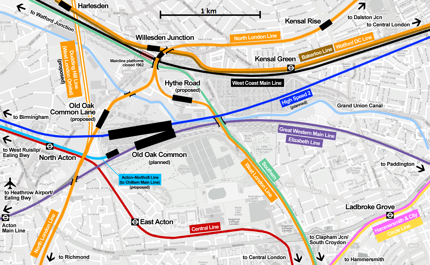
English: Map of Willesden Junction railway station with the proposed Old Oak Common railway station (planned to open 2026 or later) serving Crossrail and High Speed 2 |
| Data | |
| Fonte | Opera propria |
| Autore | Cnbrb |
| Descrizione |
Questa mappa è stata creata con dati raccolti dal progetto OpenStreetMap. La mappa potrebbe essere incompleta e contenere errori. Non affidarsi esclusivamente ad essa per la navigazione. |
|||
| Data | (see file history) | |||
| Fonte | openstreetmap.org | |||
| Creatore |
OpenStreetMap contributors |
|||
| Licenza (Riusare questo file) |
OpenStreetMap data is available under the Open Database License (details). Map tiles are licensed under the Creative Commons Attribution-ShareAlike 2.0 license (CC-BY-SA 2.0).
Questo file è disponibile in base alla licenza Creative Commons Attribuzione-Condividi allo stesso modo 2.0 Generico
|
|||
| Georeferencing | If inappropriate please set warp_status = skip to hide. |
Licenza
[modifica]
Io, detentore del copyright su quest'opera, dichiaro di pubblicarla con la seguente licenza:
Questo file è disponibile in base alla licenza Creative Commons Attribuzione-Condividi allo stesso modo 3.0 Unported
- Tu sei libero:
- di condividere – di copiare, distribuire e trasmettere quest'opera
- di modificare – di adattare l'opera
- Alle seguenti condizioni:
- attribuzione – Devi fornire i crediti appropriati, un collegamento alla licenza e indicare se sono state apportate modifiche. Puoi farlo in qualsiasi modo ragionevole, ma non in alcun modo che suggerisca che il licenziante approvi te o il tuo uso.
- condividi allo stesso modo – Se remixi, trasformi o sviluppi il materiale, devi distribuire i tuoi contributi in base alla stessa licenza o compatibile all'originale.
Cronologia del file
Fare clic su un gruppo data/ora per vedere il file come si presentava nel momento indicato.
| Data/Ora | Miniatura | Dimensioni | Utente | Commento | |
|---|---|---|---|---|---|
| attuale | 17:14, 1 ott 2023 | | 1 467 × 903 (1,15 MB) | Martinvl (discussione | contributi) | Added scale |
| 17:48, 3 mag 2023 |  | 1 467 × 903 (1,31 MB) | Cnbrb (discussione | contributi) | Elizabeth Line now open | |
| 20:36, 17 feb 2020 |  | 1 467 × 903 (1,21 MB) | RaviC (discussione | contributi) | + Acton Main Line | |
| 13:01, 2 ago 2019 |  | 1 467 × 903 (1,31 MB) | Cnbrb (discussione | contributi) | add Chiltern & W London Orbital proposals | |
| 20:39, 20 nov 2017 |  | 1 467 × 903 (1,3 MB) | Cnbrb (discussione | contributi) | update proposed new stations with official names; use official Crossrail colour for line | |
| 03:07, 27 mag 2016 |  | 1 467 × 903 (777 KB) | Briantist (discussione | contributi) | Added in the "Option C" overground stations from the TfL consultation decision. http://www.railtechnologymagazine.com/London-Underground-and-TfL/two-new-london-overground-stations-planned-at-old-oak-common | |
| 10:49, 4 lug 2013 |  | 1 467 × 903 (1,3 MB) | Cnbrb (discussione | contributi) | Watford DC line was shown incorrectly - now corrected | |
| 11:26, 17 giu 2013 |  | 1 467 × 903 (1,28 MB) | Cnbrb (discussione | contributi) | User created page with UploadWizard |
Impossibile sovrascrivere questo file.
Utilizzo del file
Le seguenti 31 pagine usano questo file:
- London Overground
- User:Chumwa/OgreBot/Potential transport maps/2016 May 21-31
- User:Chumwa/OgreBot/Potential transport maps/2017 November 11-20
- User:Chumwa/OgreBot/Potential transport maps/2019 August 1-10
- User:Chumwa/OgreBot/Public transport information/2016 May 21-31
- User:Chumwa/OgreBot/Public transport information/2017 November 11-20
- User:Chumwa/OgreBot/Public transport information/2019 August 1-10
- User:Chumwa/OgreBot/Public transport information/2020 February 10-19
- User:Chumwa/OgreBot/Public transport information/2023 May 1-10
- User:Chumwa/OgreBot/Public transport information/2023 October 1-10
- User:Chumwa/OgreBot/Transport Maps/2016 May 21-31
- User:Chumwa/OgreBot/Transport Maps/2017 November 11-20
- User:Chumwa/OgreBot/Transport Maps/2019 August 1-10
- User:Chumwa/OgreBot/Transport Maps/2020 February 10-19
- User:Chumwa/OgreBot/Transport Maps/2023 May 1-10
- User:Chumwa/OgreBot/Transport Maps/2023 October 1-10
- User:Chumwa/OgreBot/Travel and communication maps/2016 May 21-31
- User:Chumwa/OgreBot/Travel and communication maps/2017 November 11-20
- User:Chumwa/OgreBot/Travel and communication maps/2019 August 1-10
- User:Chumwa/OgreBot/Travel and communication maps/2020 February 10-19
- User:Chumwa/OgreBot/Travel and communication maps/2023 May 1-10
- User:Chumwa/OgreBot/Travel and communication maps/2023 October 1-10
- User:Mattbuck/Railways/2013 June 11-20
- User:Mattbuck/Railways/2016 May 21-31
- User:Mattbuck/Railways/2017 November 11-20
- User:Mattbuck/Railways/2019 August
- User:Mattbuck/Railways/2020 February
- User:Mattbuck/Railways/2023 May
- User:Mattbuck/Railways/2023 October
- Commons:WikiProject Aviation/recent uploads/2019 August 2
- Commons:WikiProject Aviation/recent uploads/2020 February 17
Utilizzo globale del file
Anche i seguenti wiki usano questo file:
- Usato nelle seguenti pagine di en.wikipedia.org:
- Usato nelle seguenti pagine di it.wikipedia.org:
- Usato nelle seguenti pagine di nl.wikipedia.org:
- Usato nelle seguenti pagine di yi.wikipedia.org:
Metadati
Categorie:
- High Speed 2 maps
- Elizabeth line maps
- Willesden Junction station
- London Overground maps
- London Underground maps
- Maps of the Bakerloo line
- West Coast Main Line
- OpenStreetMap maps of London
- Maps of the London Borough of Brent
- Maps of the London Borough of Hammersmith and Fulham
- Harlesden railway station
- Watford DC Line
- West London Line
- Old Oak Common Traction Maintenance Depot
- Old Oak Common railway station
- Proposed or planned infrastructure in London
- West London Orbital