File:Woodlands checkpoint.jpg
From Wikimedia Commons, the free media repository
Jump to navigation
Jump to search
![File:Woodlands checkpoint.jpg](https://upload.wikimedia.org/wikipedia/commons/thumb/7/74/Woodlands_checkpoint.jpg/800px-Woodlands_checkpoint.jpg?20110812050119)
Size of this preview: 800 × 547 pixels. Other resolutions: 320 × 219 pixels | 640 × 438 pixels | 1,024 × 700 pixels | 1,280 × 876 pixels | 2,560 × 1,751 pixels | 4,000 × 2,736 pixels.
Original file (4,000 × 2,736 pixels, file size: 835 KB, MIME type: image/jpeg)
File information
Structured data
Captions
Captions
Add a one-line explanation of what this file represents
Summary
[edit]DescriptionWoodlands checkpoint.jpg |
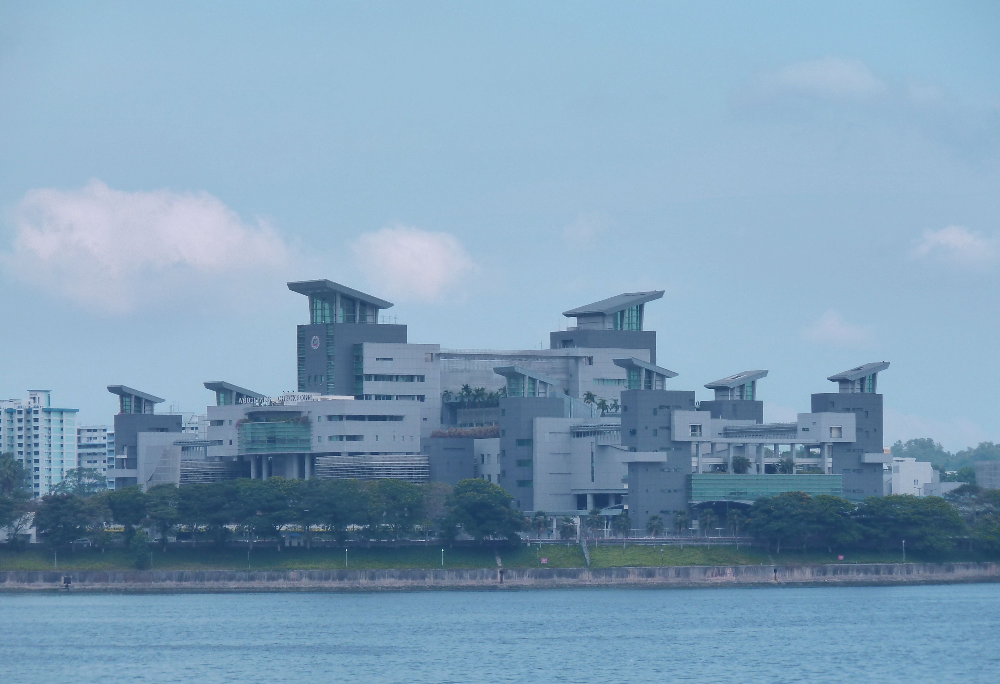
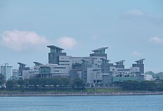
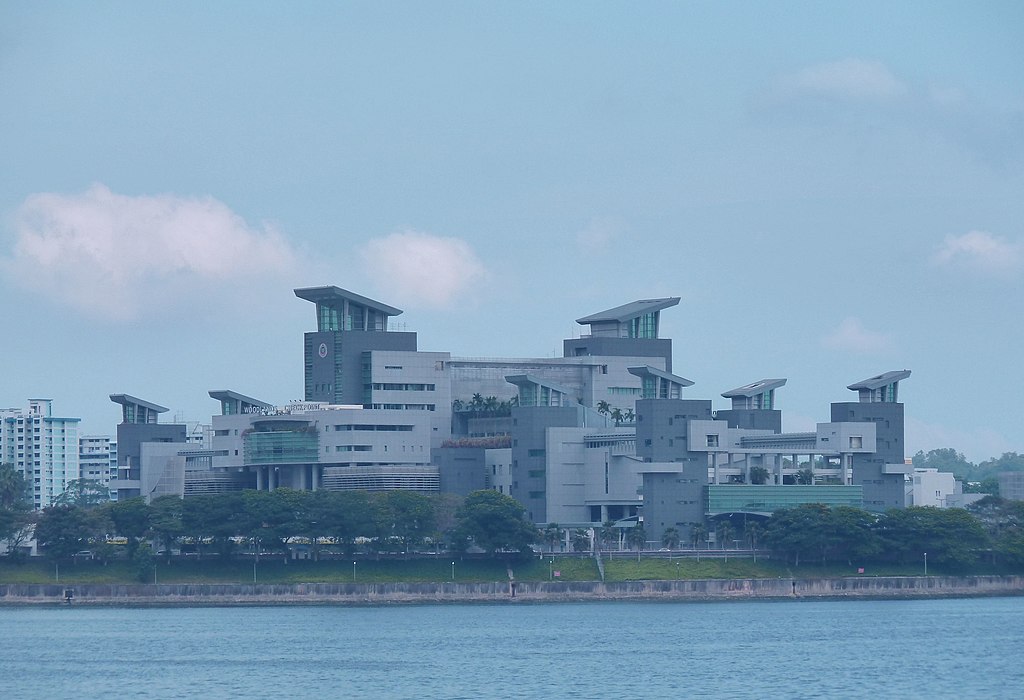
English: The Woodlands Checkpoint in Woodlands, Singapore, at the Singapore end of the Johor–Singapore Causeway.
日本語: マレーシア側から望むウッドランズチェックポイント. |
Date | |
Source | Own work |
Author | ペウゲオト. |
Camera location | 1° 27′ 25.37″ N, 103° 45′ 49.16″ E ![]() | View this and other nearby images on: OpenStreetMap | ![]() |
---|
Licensing
[edit]I, the copyright holder of this work, hereby publish it under the following license:
![w:en:Creative Commons](https://upload.wikimedia.org/wikipedia/commons/thumb/7/79/CC_some_rights_reserved.svg/90px-CC_some_rights_reserved.svg.png)
![attribution](https://upload.wikimedia.org/wikipedia/commons/thumb/1/11/Cc-by_new_white.svg/24px-Cc-by_new_white.svg.png)
![share alike](https://upload.wikimedia.org/wikipedia/commons/thumb/d/df/Cc-sa_white.svg/24px-Cc-sa_white.svg.png)
This file is licensed under the Creative Commons Attribution-Share Alike 3.0 Unported license.
- You are free:
- to share – to copy, distribute and transmit the work
- to remix – to adapt the work
- Under the following conditions:
- attribution – You must give appropriate credit, provide a link to the license, and indicate if changes were made. You may do so in any reasonable manner, but not in any way that suggests the licensor endorses you or your use.
- share alike – If you remix, transform, or build upon the material, you must distribute your contributions under the same or compatible license as the original.
File history
Click on a date/time to view the file as it appeared at that time.
Date/Time | Thumbnail | Dimensions | User | Comment | |
---|---|---|---|---|---|
current | 05:01, 12 August 2011 | ![]() | 4,000 × 2,736 (835 KB) | ペウゲオト (talk | contribs) |
You cannot overwrite this file.
File usage on Commons
There are no pages that use this file.
File usage on other wikis
The following other wikis use this file:
- Usage on ja.wikipedia.org
- Usage on th.wikipedia.org
Metadata
This file contains additional information such as Exif metadata which may have been added by the digital camera, scanner, or software program used to create or digitize it. If the file has been modified from its original state, some details such as the timestamp may not fully reflect those of the original file. The timestamp is only as accurate as the clock in the camera, and it may be completely wrong.
Camera manufacturer | Panasonic |
---|---|
Camera model | DMC-TZ10 |
Exposure time | 1/400 sec (0.0025) |
F-number | f/5.6 |
ISO speed rating | 125 |
Date and time of data generation | 16:09, 25 July 2011 |
Lens focal length | 29.9 mm |
Orientation | Normal |
Horizontal resolution | 180 dpi |
Vertical resolution | 180 dpi |
File change date and time | 16:09, 25 July 2011 |
Y and C positioning | Co-sited |
Exposure Program | Landscape mode (for landscape photos with the background in focus) |
Exif version | 2.21 |
Date and time of digitizing | 16:09, 25 July 2011 |
Image compression mode | 4 |
APEX exposure bias | 0 |
Maximum land aperture | 3.44 APEX (f/3.29) |
Metering mode | Pattern |
Light source | Unknown |
Flash | Flash did not fire, compulsory flash suppression |
Color space | sRGB |
Sensing method | One-chip color area sensor |
Custom image processing | Normal process |
Exposure mode | Auto exposure |
White balance | Auto white balance |
Digital zoom ratio | 0 |
Focal length in 35 mm film | 182 mm |
Scene capture type | Landscape |
Contrast | Normal |
Saturation | Normal |
Sharpness | Normal |
North or south latitude | North latitude |
East or west longitude | East longitude |
Satellites used for measurement | 3 |
Receiver status | Measurement in progress |
Measurement mode | 2-dimensional measurement |
Measurement precision | Poor (2.6) |
Geodetic survey data used | WGS-84 |
GPS date | 25 July 2011 |