File talk:Ethnic map of 11th century.jpg
 | This file was nominated for deletion on 20 January 2013 but was kept. If you are thinking about re-nominating it for deletion, please read that discussion first. |
Pine trees
[edit]
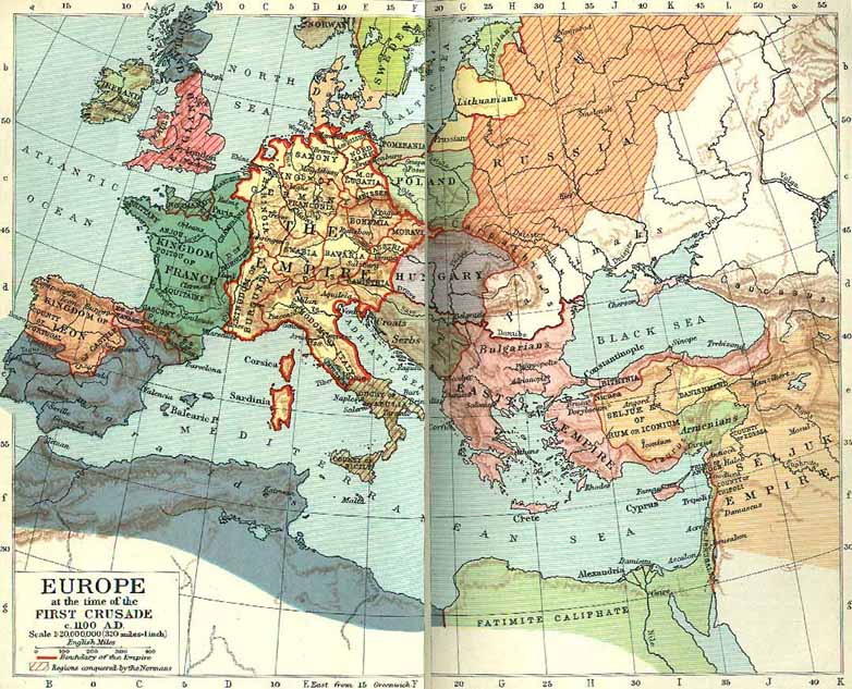
This map doesn't present a historically-accurate view but rather an extremist view of one "historian". It has gross inaccuracies and does not represent:
(see more at en:Romania in the Early Middle Ages#Last waves of migrations and formation of new states) Or maybe they are all pine trees?!
Additionally, in the 11th century, we can talk about Croats, Serbs, Moravians etc. Not just Slavs. This is not the 6th century!
Compare and contrast with: File:FormatiuniPoliticeRomanestiSecolele IX XIII.svg, File:Evolution of the Eastern Romance languages and of the Wallachian territories from 6th century to the 16th century AD.jpg, File:South-eastern Europe 1040.jpg, File:Realms of Ahtum and Sermon in the 11th century.png, File:Gesta hungarorum map.jpg
As such, I propose to be removed or completely redone using MULTIPLE reliable sources. Minimally it should be renamed to "A view on the ethnic distribution in the Kingdom of Hungary in the 11th century.jpg"
The way it stands right now, it cannot be used in any Wikipedia articles without being considered Original Research and POV
P.S.: See also discussion at en:File talk:Ethnic map of 11th century.jpg
--Codrin.B (talk) 09:36, 20 January 2013 (UTC)
- Pechenegs -----They were Turkic people they are on the map.
- Cumans----- They arrived later in the 13th century.
- Bulgars-----They were Slav/Turkic population, The Slav population in Transylvania is on the map (and some Turkic as well).
- Germans\Germanic tribes-----There was no Germanic people in kingdom of Hungary the 11th century.
- Vlachs (Romanians)----It is a historical debate whether they were in Transylvania or not in the 11th century.
- mixed Slav-Vlach populations ----Same problem as above.
Fakirbakir (talk) 12:57, 21 January 2013 (UTC)
- Support This historically controversial map should be deleted because it is in contradiction with historical facts. It is also based on one vague source onlyWP:FRINGE, while other sources indicate otherwise.Iadrian yu (talk) 11:24, 20 January 2013 (UTC)
- Support The map is very dubious taking in account the other maps for the same period. Saturnian (talk) 11:36, 20 January 2013 (UTC)
- The voting is here [1], I was wrong to put my vote here. Iadrian yu (talk) 12:50, 20 January 2013 (UTC)
![[1]](https://commons.wikimedia.org/wiki/Commons:Deletion_requests/File:Ethnic_map_of_11th_century.jpg)
- What is wrong with you all? This map shows the Hungarian academic point of view. Properly sourced. Moreover there are hundreds of maps which ones show the Romanian point of view. Fakirbakir (talk) 12:45, 20 January 2013 (UTC)
- I don`t understand what "see also" should represent now? It is still not supporting this map, it only has some data about the Hungarian population, nothing about "Pine trees" where Vlach population lived. Iadrian yu (talk) 13:58, 20 January 2013 (UTC)
- ....where Vlach population lived according to scholars who do not accept the view presented by this map. Why is it a problem that this POV is also presented on a map based on reliable sources? Borsoka (talk) 15:20, 20 January 2013 (UTC)
- I don`t understand what "see also" should represent now? It is still not supporting this map, it only has some data about the Hungarian population, nothing about "Pine trees" where Vlach population lived. Iadrian yu (talk) 13:58, 20 January 2013 (UTC)
Since the author of this map "remembered" a few more references that can`t be checked online (At-least I and Borsoka did`t find them available). That only means that he has those books otherwise he himself would`t know that those sources support his map. If that is the case, can we please the scanned page in question? Iadrian yu (talk) 16:24, 20 January 2013 (UTC)
- It is a properly sourced map. That is all. Fakirbakir (talk) 18:38, 20 January 2013 (UTC)
- Hi guys. I was asked to comment also, so here goes:
- I think such maps are always problematic, because the demographic situation in 11th century Hungary (as far as I am aware) is not clearly documented , is it ? Therefore such maps always require controversial interepretation by backward -reconstruction based on later times, dubious (and nationalist inscpired) readings of archaeological and lingusitic data, etc. And, inevitably, they are somewhat messy , trying as they do to shade varying admixture components of different ethnic groups (and Im not even going into the very fact that ethnic groups back then could be multi-levelled and subject to change, making the notion of clearly definable Vlach vs Slavs, for eg, suspect).
- From my personal experience, I make my maps definable and clear of what the subject is. When making maps about "tribes" or ethnic groups, and their locations, I only include tribes which are mentioned by some contemporary historians. So when i constructed a map of eg 8th century Balkans, I have only the Sklavinians mentioned by sources. Thus there are no Albanians or Vlachs - though they undoubtedly existed - but were never mentioned until later. Nor were there any Croats until 9th century. Obviously this might not have been popular with some groups - but at least it is consistent with historical documentation and does not involve any element of later 'creative' interpolation.
- as for this specific map, if it is to be used as Fakirbakir says it is, then the caption on it would have to be changed clearly to state that it is a "Hungarian perspective". it should not be used as a definite statement of facts, but rather on the discussion on the historiography of the Topic. Hxseek (talk) 09:24, 21 January 2013 (UTC) -> Slovenski Volk
- I can modify the map easily if it helps. Fakirbakir (talk) 10:32, 21 January 2013 (UTC)
- It is done. I have inserted "Hungarian perspective" into the map for the sake of accuracy. Fakirbakir (talk) 10:44, 21 January 2013 (UTC)
- Other editors convinced me to change my mind. See explanation in the File. Fakirbakir (talk) 17:17, 21 January 2013 (UTC)
I see the third source is available online now, but I still don`t understand it nor what it should represent. I will put verification needed tag until that clears up since I can`t see that source sporting this map.Iadrian yu (talk) 08:45, 23 January 2013 (UTC)
- It supports it with archaeological finds. (Kniezsa's map is based on hydronymy). Fakirbakir (talk) 09:27, 23 January 2013 (UTC)
- And where exactly on this map is indicated where and which ethnic group lived? Of course that would in conclusion support the map you created in the form exactly that it is? Iadrian yu (talk) 12:47, 23 January 2013 (UTC)
- The main source is Kniezsa's map (based on hydronymy and place names). But other Hungarian academic works also support its viewpoint. For example the third source shows us where we can find Hungarian settlements in the 11th century (with the help of archaeological findings) and its results are almost identical with Kniezsa's work. Fakirbakir (talk) 13:26, 23 January 2013 (UTC)
- Where did you read that the map is "based on hydronymy and place names"? Iaaasi (talk) 13:33, 23 January 2013 (UTC)
- The main source is Kniezsa's map (based on hydronymy and place names). But other Hungarian academic works also support its viewpoint. For example the third source shows us where we can find Hungarian settlements in the 11th century (with the help of archaeological findings) and its results are almost identical with Kniezsa's work. Fakirbakir (talk) 13:26, 23 January 2013 (UTC)
- And where exactly on this map is indicated where and which ethnic group lived? Of course that would in conclusion support the map you created in the form exactly that it is? Iadrian yu (talk) 12:47, 23 January 2013 (UTC)
Ok, it is a map based on hydronymy and place names. Where is it depicted exactly where and which ethnic group lived? Example:We have a name of the river Tisa (Hungarian:Tisza). It is pronounced and written as "Tisa" in 6 languages (nations). So based on that name (as this map is based on hydronymy and place names) , "Tisa", who lived there? Ukranians? Serbs? Romanians? Croatians? Slovakians? or .... Rusyns? Iadrian yu (talk) 13:40, 23 January 2013 (UTC)
- The name is of Latin origin. The river was known as the Tissus or Tisia in antiquity Iaaasi (talk) 13:55, 23 January 2013 (UTC)
- So by this type of research it means Vlach population lived there? Because I don`t see any other Latin people in the vicinity.Iadrian yu (talk) 14:44, 23 January 2013 (UTC)
We have abandoned the subject. About the third reference, where is it depicted exactly where and which ethnic group lived on this map? Iadrian yu (talk) 15:26, 23 January 2013 (UTC)
Map contradicting Ethnic map of 11th century.jpg
[edit]
http://www.culturalresources.com/images/maps/Eur1100Big.jpg
You can see here a vast territory controlled by Pecheneges, which don't exist on Fakirbakir's map Iaaasi (talk) 08:52, 23 January 2013 (UTC)
- Sorry, but it contradicts nothing. Your map is not even an ethnic map. And actually Turkic Pechenges are on my map (green).Fakirbakir (talk) 09:10, 23 January 2013 (UTC)
- Pechenges (Patzinaks) are controlling the whole of Transylvania on this map, not just a few villages Iaaasi (talk) 09:33, 23 January 2013 (UTC)
- Do you know Hungarian history well? When did they occupy Transylvania? :) Fakirbakir (talk) 09:38, 23 January 2013 (UTC)
- Pechenges tried to attack Hungary, but they were defeated. Fakirbakir (talk) 09:41, 23 January 2013 (UTC)
- Do you know Hungarian history well? When did they occupy Transylvania? :) Fakirbakir (talk) 09:38, 23 January 2013 (UTC)
- Pechenges (Patzinaks) are controlling the whole of Transylvania on this map, not just a few villages Iaaasi (talk) 09:33, 23 January 2013 (UTC)
Third source
[edit]
The third source needs to be removed from the list of the references since nowhere on this map can`t be seen the ethnic composition of that area.Iadrian yu (talk) 08:49, 24 January 2013 (UTC)
- I agree Iaaasi (talk) 09:48, 24 January 2013 (UTC)
Ethnic groups and linguistics
[edit]
A few more points:
- We cannot talk about ethnic groups distribution based on LINGUISTICS research. Each wave of conquerors/invaders tends to rename everything from places to rivers. It doesn't mean based on those "new names", that the conquered native population (Slavs, Vlachs, Bulgars, Cumans) have become instantly "ethnic Hungarians". But we don't have a census for the subjects for the Kingdom of Hungary from the 11th century to see how the subjects would identify themselves "ethnically". Without such information, we cannot draw an ethnic map using some obscure linguistics studies
- See the term en:Ethnic group, which was invented far later. We can't use it in this context
- Modern genetics has shown that a very small part of the modern Hungarian DNA comes from the asiatic Magyars. See [2] and other references at the bottom of en:Hungarian people article. Which means that in the 11th century, just a tiny minority of the people in the Kingdom of Hungary were of Magyar descent. They were the leaders (note that after a few generations even the kings got intermarried with Western Europeans for obvious reasons). The large majority of the people were the subjects who were anything but Magyars. They were Slavs, Vlachs, Bulgars, Cumans later Germans. This is the only logical and obvious explanation for the genetic research. And this will paint a RADICALLY DIFFERENT ethnic map, that is if we need to draw such a ridiculous map.
- Székelys are (were!) not Hungarian - see en:History of the Székely people; their en:Magyarization was not complete in the 11th century
- If we were to build linguistic map solely based on hydronyms and toponyms, then let's use them all. Transylvania is full of Slavic hydronyms and toponyms, but also has Dacian, Thracian, Iranic, Turkic and Roman. Where are they on the map?
If this propaganda and grossly inaccurate map gets kept, it must be renamed to "A linguistic map of the Kingdom of Hungary in the 11th century based on research by XXX.jpg".--Codrin.B (talk) 12:02, 24 January 2013 (UTC)
- Why do you think that the conqueror Magyars were "Asiatic"? Do you know that West Asia, Central Asia, and South Asia are "Europeans" in the sense of genetics? You also forget that Magyars spent thousand years in Eastern Europe (next to the Slavs, Turkic peoples) moreover conqueror Hungarians had similar characteristics to Andronovo culture. How you could explain the survival of Hungarian language? Small "elite" minority would have been unable to force "language exchange" (and do not forget Latin had been the "official" language since 1000 AD). Moreover medieval kingdom of Hungary had about 80% Hungarian majority according to demographers. Fakirbakir (talk) 21:02, 24 January 2013 (UTC)
- Moreover medieval kingdom of Hungary had about 80% Hungarian majority - this is only a modern supposition, not a fact Iaaasi (talk) 21:15, 24 January 2013 (UTC)
Territory of the K. of Hungary
[edit]
The borders of of the K. of Hungary that are proposed here are questionable. According to other maps Trasnylvania was not under complete Hungarian control in those times [3] [4][5] Iaaasi (talk) 11:35, 25 January 2013 (UTC)
![[3]](https://sphotos-f.ak.fbcdn.net/hphotos-ak-ash3/550061_589363957744688_637566076_n.jpg)
- I bet I could find more maps about "Hungarian Transylvania" in the 11th century. The Pechenges plundered Transylvania however they were defeated in 1068. It was never annexed to Pechenges territories. [6][7] [8][9] Fakirbakir (talk) 12:17, 25 January 2013 (UTC)
- On Euratlas map the south-eastern Transylvania is not part of Hungary [10] Iaaasi (talk) 12:28, 25 January 2013 (UTC)
- as an aside, euratlas is not reliable . A lot of errors and 'made up' tribal names. Unfortunately most maps even historically 'accepted' ones , are incorrect , simplifications , etc. we simply cannot accurately reconstruct demographic & ethnic territories from 11tj century Pannonia; even with the aid of archaeology. Many past attempts are 'culture -historical' and simply false 101.119.15.62 01:27, 6 February 2013 (UTC)
- On Euratlas map the south-eastern Transylvania is not part of Hungary [10] Iaaasi (talk) 12:28, 25 January 2013 (UTC)
Reply to a few things in the deletion discussion (@Samofi)
[edit]
1) Yes, exactly. 70+ is a long time and thus if the map hasn't been questioned by mainstream historians then I suppose that its data has been more or less confirmed by archeological findings as well. If that won't be the case, the map would've been already challenged on some more scientific grounds than the plain "I don't like the things that it shows, and even though I can't prove otherwise, it MUST be wrong" kind of arguments. Also, you seem to assert that even the mountainous areas of Upper Hungary were "densely" populated (presumably by Slavs) since "ancient times", but that contradicts even the basic rules of demographics. Other sources estimate the Carpatian basin's TOTAL population to be a few million AT MOST, and we know that the mounts are quite sparsely inhabited places even up to this day. So while I don't deny the fact that the areas of Orava, Kysuca and Upper Hron WERE inhabited, but the map doesn't contradict this statement either (i.e. asserts that those areas had "sparse slav" population). What's so bad about it then?
2) Actually the majority of Siberia is largely uninhabited up to this day. I mean outside of the settlements you can drive like 100s of kms without finding as much as a hut. You're telling me that despite that such places would be "populated" by a minority? Also, Russia's still full of minorities with a nomadic lifestyle, which (for obvious reason) are very hard to demographically assess and mark on a map. 19th century Hungary however (besides the Gypsies) didn't have any nomadic people living within the state, so areas which have been marked as uninhabited really WERE very sparsely populated. And the "village" of Makov you cited isn't a good example either, because it seems to be little more than an administrative unit encompassing microcommunes that are spread in a VERY large area. In fact there are still a lot of similar places in Transylvania that are just as sparsely populated and are marked as "uninhabited" on Teleki's map in the very same way (e.g. communes with population of 20-30 that's spread on a few km of land). Densely populated areas on the other hand are packed with villages that are VERY close to each other and even could be united into larger cities (e.g. have you ever been near Dunajská Streda? It has sooo many villages in its near vicinity that its "suburb" network is perhaps more populous than the city itself). And even though I agree with the fact that SOME of the population has been ignored, but definitely not more than 1-2% at most.
You keep asserting that the map has served propaganda purposes. You base this opinion only on the fact that VERY sparsely populated areas are marked as "uninhabited"? Because I think that IF the map would've REALLY served propaganda purposes, then the map would contain outright lies, which it doesn't (it uses VERIFIABLE statistical data made by KSH during the 1910 census which can be accessed, read and verified at the archives by anybody). In fact the representation of the Hungarian populace is verifiable from other, INDEPENDENT sources as well. Or does your opinion stem from the fact that it was used as an argument when Hungarian elite was forced to sign the "peace" treaty of Trianon? Tell me, how do you explain the presence of quite sizable Hungarian minority up to this day then? Illegal immigration? "Saboteur" work? Appearance out of thin air? Magyarization even after ALL the Hungarian colleges and universities were forcibly closed down (and their crew driven away to Hungary) and the reduction of Hungarian high schools to the fraction of their original amount? -- CoolKoon (talk) 14:30, 27 January 2013 (UTC)
(P.S. Hey! It's not my fault that you've closed the voting while I was making this post!)
)
- Shortly about this map. 1) You wrote: "So while I don't deny the fact that the areas of Orava, Kysuca and Upper Hron WERE inhabited, but the map doesn't contradict this statement either (i.e. asserts that those areas had "sparse slav" population). What's so bad about it then?" Fact is, that these reagions are not marked as "sparse slav" areas. Sparse slavs according to this map are in: Zilina basin, Turiec basin, Liptov basin, Podtatranska basin and Hornadska basin. In fact these terriotories were normaly inhabited by Slavs. Case study Zilina basin [11]: Hradisko till 10th century at Velky vrch and small castle at Hradisko mount from 12th century. Sparse Slav population had feudals, hradisko and little castle? 2) In fact Orava, Kysuce, Spis, Upper Hron, Upper Latorica and Upper Ondava regions are in map marked as forrests. Its not true, Slavic people inhabited these areas since 6-8 century. Case study Orava [12]: I will cite Michal Čajka, PhD. - archeologist: "Slovania prišli na Oravu na prelome ôsmeho a deviateho storočia, zostali natrvalo." - "Slavs came to Orava on the turn of 8-9 century and stayed here ever since." In Spis were findings from 8-10 century till 2010. In 2011 found slavic sttlements from 6-7 century: [13] They lived deep in forrests in the basins of small rivers in small wooden houses. Mountains were used for forrestry and pastoralism. They lived in symbiosis with mountains and forrests. It were not empty forrests as this map tries to say. It looks that author automaticaly marked areas 400m above see level as forrests... --Samofi (talk) 14:11, 29 January 2013 (UTC)
- I finally managed to go through the sources you provided. You're right with your first source: it DOES in fact confirm that the area of the Zilina basin was not sparsely populated, because having a remnants of a castle (and a lot of cemeteries from that time) means the amount of population was more than "sparse". So I'd agree with changing the spot representing the Zilina region from light blue to dark blue.
- As for the Orava region, I'd suggest coloring it to light blue indicating "sparse Slav" population (as the findings described in the second article describe little more than that).
- However I have to disappoint you for the rest of the locations you mention, because they aren't covered in any of the articles and thus no hard evidence seems to confirm that all the regions described by you have been inhabited in the 11th century. The Spis area is already marked as "sparsely populated Slav" area on the map and the (3rd) article you cited doesn't refute that (it only states that the area has been populated earlier than originally believed, but the findings don't point to more than sparse populace).
- Also Fakirbakir, regardless of the contents of the map I have a proposal: how about ditching this version of the map completely and uploading a PNG version instead? It'd not only be smaller (because images with few different colors compress quite well with PNG), but it'd also avoid having the edges messed up by the lossy JPEG compression (which's present even when setting the quality factor to 100). In the new version both changes described above could be incorporated and the three sources provided by Samofi could be added for additional support as well. -- CoolKoon (talk) 21:25, 24 February 2013 (UTC)