File talk:Kis-vlachföldek.png
 | This file was nominated for deletion on 6 May 2022 but was kept. If you are thinking about re-nominating it for deletion, please read that discussion first. |
Problems with the map
[edit]
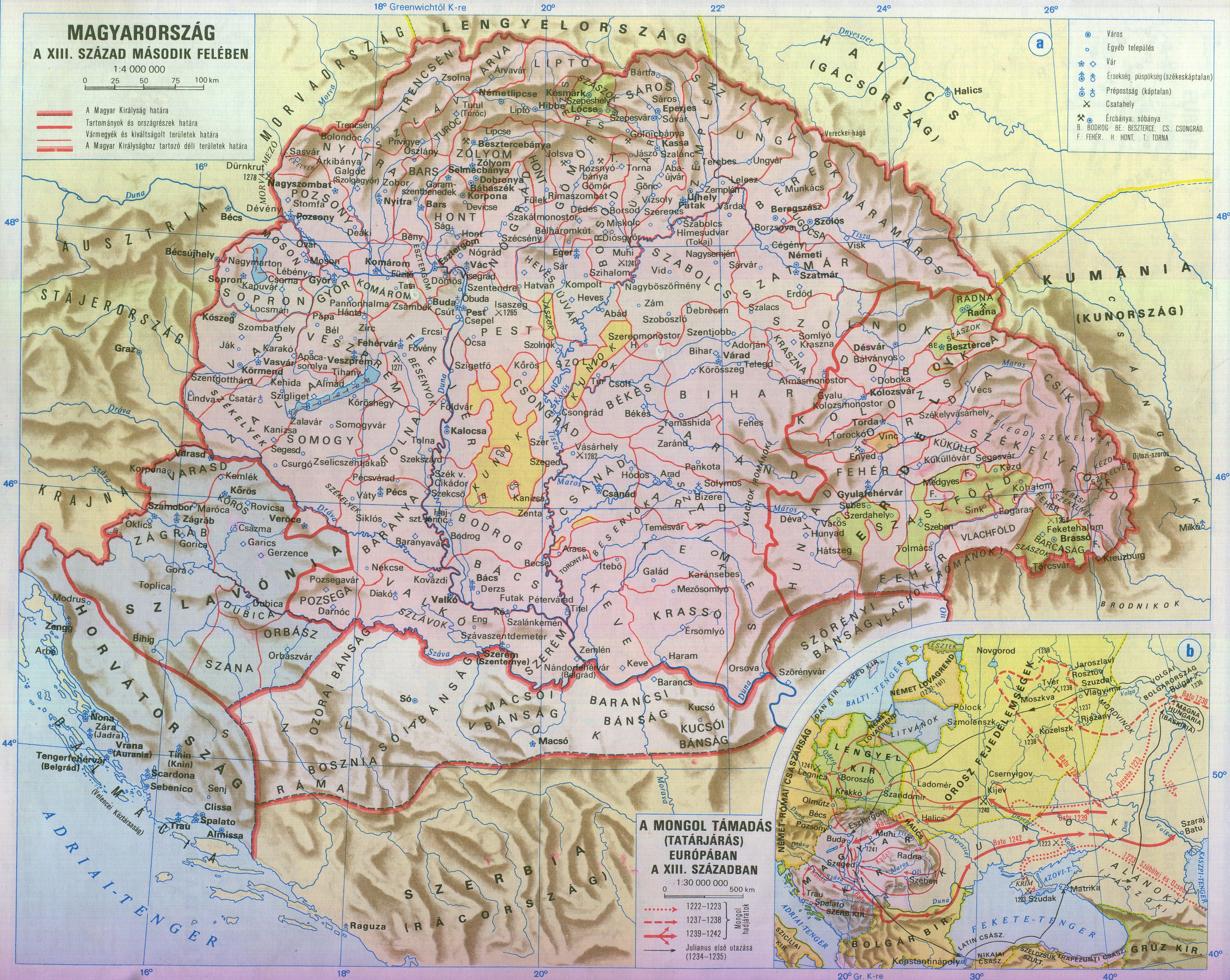
I would like to ask the editors to stop spreading biased, ultra-nationalist narratives! The original version of the map showed the areas of the Hungarian kingdom's autonomous territories with different color codes in the 13th century, but this has been edited beyond recognition and false information has been added. The Vlach law, marked in orange, did not grant autonomy, only various tax discounts. Again, not autonomy, so it should not be marked on the map with colour code. No one disputes the presence of Romanians in Transylvania in the 13th century, it is a fact. Nobody disputes the existence of Vlach law either. In order to preserve authenticity and neutrality of the map, I have restored the map to its original version, which marks both the local ethnic groups like the Romanians and the autonomous territories (yellow, green, blue patches) as well. I do not think that wikipedia is meant to be a playground for ultra-nationalists who modify and redraw maps at will to promote their own historical views, so the map should remain in its original, neutral form. Besides, it was not only the Romanians who lived under Vlach law, and not only in Transylvania, but also the Carpathian Rusyns, and everyone else who was a shepherd. This also shows that the modification of the map had no other purpose than to show Transylvania as a territory already then completely inhabited by Romanians in the 13th century. However, the editor of the map had no real knowledge about the subject, it served only her nationalist views. In any case, it is impossible to depict Vlach law, because it was only a form of taxation that applied to nomadic, non-agricultural peoples, who lived everywhere alongside settled peoples who did not live under Vlach law. Thus, it is impossible to separate Vlach law from non-Vlach law territories. There were no Vlach-law areas, only villages under Vlach law, founded by the Kenéz, where Romanians and Ruthenians were settled with royal permission, and persons who taxed according to Vlach law (1 for every 50 sheep had to be given to the royal treasury).) But alongside these villages there were also villages with traditional agriculture, where taxes were paid in the traditional way (church tithe, robots for the landlord, etc...) How could this be represented in any way on a map?. --Enlightenment1685 (talk) 02:15, 4 June 2022 (UTC)
- The romanian nationalist "pov" claims that Transylvania was a Romanian principality with Wallachian voivodes. The hungarian nationalist "pov", here explained by Enlightenment1685, denies the existence of the vlach nomadic shepherds until the 13th century and minimise & reletivise the Vlach Jog. Several toponymic, linguistic and archaeologic works go against these extreme opinions. Vlach Jog is attested by Mihályi János : Magyar diplomák a XIII és XIV századbol and some other hungarian historic atlases. This other map [1] expresses the Hungarian nationalist point of view, and we respect it, so please respect too this one here. Thank you. --Trecătorul răcit (talk) 13:22, 25 June 2022 (UTC)
- Please stop with the strawman argument and stop putting statements in my mouth that I never said. Please reread my previous reply because you clearly have no clue on the subject. First of all, Transylvania was not a Romanian principality, as the Transylvanian voivodes were promoted by the Hungarian kings until 1526, but all of this is irrelevant to the discussion. You obviously have no knowledge of the subject and think that Vlach law means that the Romanians of Transylvania ruled themselves. This is not the case. Vlach law was a special form of taxation in the villages with Vlach law, which were run by the keneses. The keneses were, in today's terms, entrepreneurs who received permission from the Hungarian king to settle Romanians on the royal lands. Please educate yourself on the subject and get a basic knowledge of it before you make false statements out of ultra-nationalist inditement. I will be very happy to recommend you literature if you wish. "Vlach Jog is attested by Mihályi János : Magyar diplomák a XIII és XIV századbol" Please specify which page the information you are referring to is on! Enlightenment1685 (talk) 00:42, 1 July 2022 (UTC)
- EDIT - Yesterday I reset the map to the original version, but I reset it back to your version. I agree with you that there is a need for such a map, and I don't want to play a reset war with you, but it would be good if you read more about the topic, because it is obvious that you don't have a deep knowledge of the subject. If you would like, I would be happy to recommend you appropriate literature. Please study the subject carefully before you start drawing maps, because it is still false in this form. Enlightenment1685 (talk) 20:50, 1 July 2022 (UTC)
- Please, I never accused you of being a straw man or ignoring the subject. That Transylvania would be a Romanian principality is a Romanian nationalist point of view that I quoted without approving it: I wrote in many texts that it was ruled by Hungarian nobility. But this does not mean, as Hungarian historiography asserts (which denies any validity to Romanian research, simply because it is Romanian) that the Wallachian law would only be a permission for colonization with tax reduction. The knyaz (slavic title) actually had a degree of managerial autonomy over several royal lands (and not only), which the royalty had found at time of Honfolalás and respected. As often, reality seems to have been halfway between the two nationalist points of view, Hungarian and Romanian, and I never said anything else. In the times we are talking about, the word Vlach did not yet have an ethnic meaning but designated peasants and shepherds (orthodox after 1054, in German altglaübig) who could be both Slavic or Romance speakers, but who, in any case, depended on the Bulgarian Church and whose written archives are in Slavonic
Contempting me, you are convinced that I have read nothing on the subject, whereas I have at home the complete version of Béla Köpeczi (dir.), History of Transylvania, 3 vol., Boulder, East European Monographs, 2001-2002; and you? do you have the complete version of A. Dragoescu (ed.), History of Transylvania, 2 vol., Cluj/Kolozsvar, 1997-1999? Come on, let's try to collaborate nicely in moderation, according with the west-European way of life. Yes, we can. Friendly, --Trecătorul răcit (talk) 16:24, 13 July 2022 (UTC)- OK, now I understand your point of view. It's clear now. Enlightenment1685 (talk) 06:06, 9 August 2022 (UTC)
- Hi @WajWohu,
- This map is a photoshopped fantasy map by a blocked user Special:Contributions/Julieta39, I show an another fake map example, created by the same user, (finally I found and I replaced the original French map), Juliteta detached Transylvania from Hungary and photoshopped a big Romania country there: File:Europe Moyen-âge.jpg in 1300. Romanian historiography with the Daco-Roman myth produced a lot of absurd fake maps to justify the territorial claims againts Hungary. Dacia!? in the 9-13th century [11] fake map from 1980s from the national-communist times, Romania 9-13th century: [10]. If we see international Europe maps, we will not find this "Romania" country in the historical maps of Europe of that timeline: [11][12][13] Those maps are clearly a falsifications and abuse of the international and Hungarian historiography.
- Many users from Romania do the same things, removing Transylvania from medieval Hungary and making Romanian country from that period against international academic maps, other example: Commons:Deletion requests/File:Europe 1097-corrected.jpg
- I see Enlightenment1685 has right, he summarized well the things.
- https://en.wikipedia.org/wiki/Vlach_law Nobody deny the existence of Vlach law. The Vlach law was a formation of taxation and special rights, not autonomy regions with borders. What is the academic source of that Vlach regions in 1200s Hungary which was arbitrary drawn by an user?
- This was the base map: File:Hungary 13th cent.png
- This is the academic source map: https://djnaploja.files.wordpress.com/2015/11/magyar-kirc3a1lysc3a1g-xiii-sz.jpg
- We cannot see borders for that "Vlach law" area in the academic base map, according to the Hungarian historiography Vlach law was introduced in Hungary in the 14th century and not in the 13th century, in Hungarian sources the number of Vlachs was small in the 13th century, and I have academic sources regarding the 14th century which shows the increase of Vlach settlements in Hungary.
- The purpose of the map is serving the Daco-Roman myth: "always majority Romanians between Tisza-Dneister river in that huge 300,000km2 land and we hid in caves for 1000 years and then suddenly emerged in Transylvania" just the problem, nobody knew about that allegedly always majority people before 1200...
- British historian, Martyn Rady - Nobility, land and service in medieval Hungary: page 90 [2] "The sources consistently refer to Wallachia as being a largely uninhabited woodland before the thirteenth century, and, until this time, they contain no explicit references to Vlachs either here or anywhere in Hungary and Transylvania."
- At the conference held in Freiburg in 2001, eight German, two Hungarian and one Romanian historians and linguists debated the issue of Daco-Romanian continuity and took a 10:1 position against it. [3] OrionNimrod (talk) 14:35, 18 February 2024 (UTC)
- @ OrionNimrod, @ Enlightement1685, @ Trecătorul răcit: Our discussion about it you may find here very long with other maps. In my opinion the photoshopped borders of Vlach settlement areas are not even bad in western and southern areas and the distinction of Jászok and Kunok settlement areas is a progress to the former map. But in comparison to other reliable maps (some of them you may see in this discussion on de:WP) the borders of Vlach and Saxon areas in northern Transsylvania are wrong and have to be corrected.--WajWohu (talk) 13:18, 21 February 2024 (UTC)
- OK, now I understand your point of view. It's clear now. Enlightenment1685 (talk) 06:06, 9 August 2022 (UTC)
- Please, I never accused you of being a straw man or ignoring the subject. That Transylvania would be a Romanian principality is a Romanian nationalist point of view that I quoted without approving it: I wrote in many texts that it was ruled by Hungarian nobility. But this does not mean, as Hungarian historiography asserts (which denies any validity to Romanian research, simply because it is Romanian) that the Wallachian law would only be a permission for colonization with tax reduction. The knyaz (slavic title) actually had a degree of managerial autonomy over several royal lands (and not only), which the royalty had found at time of Honfolalás and respected. As often, reality seems to have been halfway between the two nationalist points of view, Hungarian and Romanian, and I never said anything else. In the times we are talking about, the word Vlach did not yet have an ethnic meaning but designated peasants and shepherds (orthodox after 1054, in German altglaübig) who could be both Slavic or Romance speakers, but who, in any case, depended on the Bulgarian Church and whose written archives are in Slavonic
- EDIT - Yesterday I reset the map to the original version, but I reset it back to your version. I agree with you that there is a need for such a map, and I don't want to play a reset war with you, but it would be good if you read more about the topic, because it is obvious that you don't have a deep knowledge of the subject. If you would like, I would be happy to recommend you appropriate literature. Please study the subject carefully before you start drawing maps, because it is still false in this form. Enlightenment1685 (talk) 20:50, 1 July 2022 (UTC)
![[1]](https://commons.wikimedia.org/wiki/File:Hungary_13th_cent.png)
![[11]](https://stefanteris.files.wordpress.com/2013/02/atlas-istoric-geografic-al-neamului-romc3a2nesc_07.jpg)
![[10]](https://tortenelemportal.hu/wp-content/uploads/2012/05/roman-9-13-sz.jpg)
![[11]](/wiki/File:Europe_mediterranean_1190.jpg)
![[12]](https://upload.wikimedia.org/wikipedia/commons/d/d2/People%27s_Crusade_%28cs%29.JPG)
![[13]](/wiki/File:Europe_in_the_14th_Century.jpg)
About publishing wars between Magyars and Romanians contributors since years
[edit]
We have here, on the one hand a Hungarian historiography that is the only one to be serious and true, and on the other hand a «nationalist and lying Romanian historiography», but real History it is not that simple. The Austro-Hungarian and Russian thesis of the «vanishing during thousand years» of the Eastern Romance speakers between 276 and the 14-th century, which the hungarian contributors push here, convinced that only their sources are «international and academic», is only one of three theses, all three of which have arguments and are presented in secondary university sources:
- a first thesis, supported by books like Eduard Robert Rössler, Romänische Studien: untersuchungen zur älteren Geschichte Rumäniens ("New Studies: Investigations into the Ancient History of Romania"), Leipzig, 1871 or Béla Köpeczi (dir.), Erdély rövid története ("Abridged History of Transylvania"), Akadémiai Kiadó, Budapest 1989, ISBN 9630559013, asserts that the Romance populations disappeared north of the Danube in the 3-th century and did not reappear until the 14-th century at the earliest: the Magyars were therefore the first people in Transylvania;
- a second thesis, supported by books like История на България ("History of Bulgaria") volume III, Sofia 1982 or Ivan Duychev, Идеята за приемствено стта в средновековната българска държава (“The idea of continuity in the medieval Bulgarian state”), in: Проучвания върху средновековната българска история и култ ура (“Studies in Medieval Bulgarian History and Culture”), Sofia 1981, pp. 74–78, states that there were no Roman populations south of the Danube before the 14-th century, these having survived only north of the Danube after the withdrawal of the Roman Empire in the 3-th century: the Southern Slavs and the Proto-Bulgarians were therefore the first peoples in the Balkans;
- a third thesis, supported by books like Rumen Daskalov, Alexander Vezenkov, Entangled Histories of the Balkans - Shared Pasts, Disputed Legacies) Vol. III in Balkan Studies Library, Brill 2015, ISBN 9004290362, or Alexandru Avram, Mircea Babeş, Lucian Badea, Mircea Petrescu-Dîmboviţa and Alexandru Vulpe (dir.), Istoria românilor: moştenirea timpurilor îndepărtate ("History of the Romanians: the heritage of ancient times") vol.1, ed. Enciclopedică, Bucharest 2001, or History of Romania, Romanian Cultural Institute (Center for Transylvanian Studies) 2005, pp. 59–132, ISBN 978-973-7784-12-4, asserts that the Eastern Romance populations never stopped their transhumant pastoral travels between the north and the south of the Danube from the end of the 3-th century to the beginning of the 14-th century and thereafter.
Wikipedian contributors do not have to decide between these three theories, but to present all three. Regardless, even if the arguments for all three theories were worthless, insufficient evidence proves neither the absence nor the presence of a population. In any case, it is unrealistic to imagine that the speakers of the Eastern Romance languages could disappear for a thousand years only to reappear inexplicably afterwards, and that this group would be the only one not to able to cross the Danube, the Balkan mountains and the Carpathians, while the Goths, the Slavs, the Avars, the Proto-Bulgarians , the Magyars, the Pechenegs, the Cumans, the Alans, the Tatars and the Ottomans did. Although the activist contributors engage in an editing war to sometimes mention, sometimes erase this group, one fact remains and constitutes in itself irrefutable proof of linguistic continuity between the end of the 3-th and the beginning of the 14-th centuries: the Eastern Romance languages exist north and south of the Danube.
The insistence of the Magyar contributors to remove the maps or mentions which show a continuity north of the Danube is issued from the nostalgia for “Greater Hungary” tragically dismembered in 1920 (by the Allies and in particular the will of the french leader Georges Clémenceau and the american president Woodrow Wilson with his “14 points"), and also in the illusion that if they managed to demonstrate that the Magyars arrived there before the Romanians, this could delegitimize Romanian sovereignty over Transylvania and give Hungary a chance to recover this region.
Magyar contributors have particularly strived to erase this map here and also this other org/wiki/File:RomaniaHistRegions.jpg which, according to them, would be the expression of “Romanian irredentism”. In fact, modern Romania extends over several historical European regions inherited from medieval geography, some of which it shares with its neighbors, including Hungary.
However, these Magyar contributors consider that a historical region cannot belong to several modern countries but must be framed within the current borders of a single one, thus subjecting history to current geography. For them, the adjective românești can only mean «claimed by modern Romania» (while in reality it means «also inhabited by some Romanian populations»). For those who think that Romanians have no history before 1856, a traditional region cannot be a «common historical heritage» (e.g. Hungary and Romania sharing historical regions like Banat or the Körösvidék-Crișana). These ideas are not specific to Romania: there are contributors who think that Italians did not exist before the “Risorgimento” since it was the latter which created the consciousness of being Italian, and that they therefore have no history before 1870. This is why, wherever they can, the Magyar contributors remove this map as well as any historical map which does not adopt their point of view.
These controversies and this mutual denigration prove Winston Churchill right when he said: “The Balkan region has tendency to produce more history than it can consume.” ![]() . 2A01:CB1C:821F:A400:9104:CD3F:AFC9:53FF 10:48, 5 June 2024 (UTC)
. 2A01:CB1C:821F:A400:9104:CD3F:AFC9:53FF 10:48, 5 June 2024 (UTC)