Maps of the Netherlands
Naar navigatie springen
Naar zoeken springen
 |
- Maps are also available as part of the
 Wikimedia Atlas of the World project in the Atlas of the Netherlands.
Images showing locations of provincies in the Netherlands
[bewerken] |
 |
 |
 |
 |
 |
 |
 |
 |
 |
 |
 |
 |
-
 Overview
 -
 Drenthe
 -
 Flevoland
 -
 Friesland
 -
 Gelderland
 -
 Groningen
 -
 Limburg
 -
 Noord-Brabant
 -
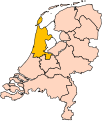 Noord-Holland
 -
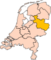 Overijssel
 -
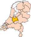 Utrecht
 -
 Zeeland
 -
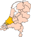 Zuid-Holland


Images showing locations of gemeentes in the Netherlands
[bewerken]
Location of Rotterdam in the Netherlands
Gelderland
[bewerken]- Aalten
- Berkelland
- Bronckhorst
- Doetinchem
- Lochem
- Montferland
- Oost Gelre
- Oude IJsselstreek
- Zevenaar
- Zutphen