<nowiki>Saas-Fee; Saas-Fee; Saas-Fee; Зас-Фе; Saas Fee; Saas-Fee; Saas-Fee; Զաս-Ֆե; 薩斯費; Saas-Fee; Saas-Fee; ザースフェー; Saas-Fee; Saas-Fee; סאס פה; Saas-Fee; Saas-Fee; Saas-Fee; Saas-Fee; Saas-Fee; Saas-Fee; Saas-Fee; Saas-Fee; 萨斯费; Saas-Fee; סאַס-פֿע; Saas-Fee; Saas Fee; Saas-Fee; Saas-Fee; Saas-Fee; Feyes-de-Sôssa; Saas-Fee; Saas-Fee; Зас-Фе; Saas-Fee; Saas-Fee; Saas-Fee; Saas-Fee; Saas-Fee; Saas-Fee; Saas-Fee; Зас-Фе; Saas-Fee; Saas-Fee; Saas-Fee; ساس-فيي; Saas-Fee; 자스페; municipality in the canton of Valais, Switzerland; település Svájcban; посёлок в кантоне Вале; Gemeinde im Kanton Wallis in der Schweiz; komunë në Zvicër; մունիցիպալիտետ Շվեյցարիայի Վալե կանտոնում; Kommune i Schweiz; İsviçre'de belediye; kumun suis e kanton Valais; Kommun i kantonen Valais, Schweiz; Alpelandsby i Sveits; муніципалітет у Швейцарії; gemeente in Wallis; commune suisse; gmejna w kantonje Wallis w Šwicarskej; comune svizzero del Canton Vallese; 스위스 발레주의 지자체; municipality in the canton of Valais, Switzerland; komunumo de Svislando; obec v kantonu Valais ve Švýcarsku; lungsod; Saas Fee; サースフェー; ザース・フェー; サース・フェー; Saas Fee; Saas; Saas-Fee (munisipyo); Saas Fee; Saas Fee; Saas Fee; Saas-Fee VS; Saas fee; Saas Fee; Saas-Fee VS; Saas Fee; Saas Fee</nowiki>
Q69693 identificador VIAF: 173123497 identificador GND (DNB): 4051113-3 identificador de autoridades de la Biblioteca del Congreso de EE. UU.: n79127908 identificador BnF: 16051160d identificador de referencia de idRef SUDOC: 177171421 identificador DHS: 002812 identificador J9U de la Biblioteca Nacional de Israel: 987007554946605171 identificador de relación OpenStreetMap: 1685362
Esta es una página de galería que contiene imágenes especialmente seleccionadas. Han sido elegidas como puntos destacados de un tema en particular, pero no representan la gama completa de imágenes que están disponibles en Commons. Para una selección más amplia de imágenes conectadas con Saas-Fee, ver Category:Saas-Fee.


 Saas-Fee as seen from the bottom of the slopes
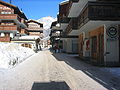
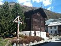 museum
 Electric vehicle on Obere Dorfstrasse
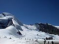 Summer ski area in Mittelallalin. Location of the ski scenes in the James Bond film On Her Majesty's Secret Service
 aerial view (1964)
 Traditional raccard granaries in Saas-Fee
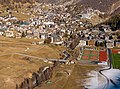 Saas-Fee mit Feevispa
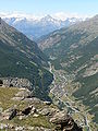


 Saas-Grund und Saas-Fee im Saastal, oberes Vispertal.
 Saas-Fee aerial view


