Maps of the world
(Redirected from World map)
Blank world maps
[edit]- Many more available in Category:Blank maps of the world
-
 Blank world map
 -
 Eckert4-World Map (as used by ARTE-TVs "Mit offenen Karten"
 -
 The World with points
 -
 Simplified blank world map without Antarctica


.svg)
Blank political world maps
[edit]-
![[CURRENT] Blank political world map](https://upload.wikimedia.org/wikipedia/commons/thumb/4/4d/BlankMap-World.svg/120px-BlankMap-World.svg.png) [CURRENT] Blank political world map
[CURRENT] Blank political world map -
![[CURRENT] Blank political world map; to facilitate identification and colorising, microstates and island nations, as well as small subnational territories, are represented as circles.](https://upload.wikimedia.org/wikipedia/commons/thumb/3/3b/BlankMap-World-with-Circles.svg/120px-BlankMap-World-with-Circles.svg.png) [CURRENT] Blank political world map; to facilitate identification and colorising, microstates and island nations, as well as small subnational territories, are represented as circles.
[CURRENT] Blank political world map; to facilitate identification and colorising, microstates and island nations, as well as small subnational territories, are represented as circles. -
 1985's world with borders
 -
 Physical world map 2004 with country borders and capitals; Robinson Projection: standard parallels 38°N and 38°S (click for large 2 MB version)
 -
 Simplified angular political world map
![[CURRENT] Blank political world map](/wiki/File:BlankMap-World.svg)
![[CURRENT] Blank political world map; to facilitate identification and colorising, microstates and island nations, as well as small subnational territories, are represented as circles.](/wiki/File:BlankMap-World-with-Circles.svg)


Thematic world maps
[edit]Economy
[edit]-
 Mining
 -
 Unemployment in 2007.
 -
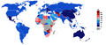
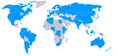
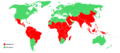
 ACP States
 -
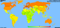
 GDP per capita 2007
 -
 GDP nominal and PPP 2007
 -
 GDP growth 2007
 -
 Inflation in 2009
 -
 Gini coefficient
 -
 Countries above and below world average GDP PPP per capita
 -
 Current Account Balance 2006
 -
 Current Account Balance 2006 as % of GDP
 -
 Current Account Balance 2006, per capita
 -
 Vegetation
 -
 soil erosion
 -
 Rainfall erosivity


Political world maps
[edit]-
 All the countries of the world
 -
 Prisoners per 100,000 citizens
 -
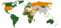
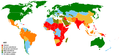
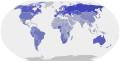
 States of the Non-Aligned Movement
 -
 States of the Middle East
 -
 APEC member countries
 -
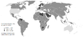
 Council of Europe
 -
 ICC member states
 -
 Kyoto Protocol participation 2009
 -
 Localisation of nuclear weapons
 -
 Ottawa Treaty members
 -
 Iberoamerican Summit
 -
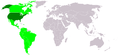
Summit of the Americas.
-
 Member states Conference on Disarmament (CD) 1981
 -
 Member states Conference on Disarmament (CD) 2007
 -
 Corruption as of 2005
 -
 Military Alliances
 -
 Bilderberg Attendees


._1981.png)
.png)


Social world maps
[edit]-
 HDI 2007/2008
 -
 Evolution of human development in the 2000s
 -
 Education Index
 -
 World literacy rates
 -
 State of population
 -
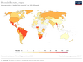
 Percentage below the national poverty line
 -
 Percentage of population living below the International Poverty Line (less than $1.90 a day)
 -
 Median age
 -
 Births attended by a skilled health personnel
 -
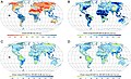
 Life expectancy
 -
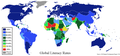
 Religion
 -
 Suicide rates per 100,000 people
 -
 Laws on homosexuality
 -
 Malaria as of 2003
 -
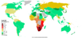 HIV prevalence as of 2004
 -
 COVID-19
 -
 Vitamin A deficiency
 -
 % of children under height for age
 -
 Abortion laws
 -
 Death penalty
 -
 Age of sexual consent
 -
 Alcohol
 -
 Smoking Males
 -
 Smoking Females
 -
 Circumcision
 -
 Homicide
.svg)


Topographic world maps
[edit]See also Topographic maps
- NOTE: The below four images are too large to be thumbnailed by Mediawiki and so will output the full 8MB images for each if displayed on a page. For the moment, they have been linked to in order to prevent this page from downloading 32MB of images each time it is loaded.
- File:WorldMap-A non-Frame.png—Topographic world map, none frame (8MB)
- File:WorldMap-A with Frame.png—Topographic world map, with frame (8MB)
- File:WorldMap-B non-Frame.png—Topographic world map, none frame (8MB)
- File:WorldMap-B with Frame.png—Topographic world map, with frame (8MB)
  |
  |
  |
  |

Old world maps
[edit]- Many more available in Template:Maps_of_world_history
-
 after Anaximaner and Hekataios, about 510. B.C.
 -
 Beatus Ms, 12th century
 -
 in Apocalypse of St. Severe
 -
 1467
1467 -
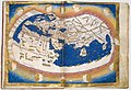
 1493
1493 -
 1493
1493 -
 1548
1548 -
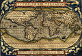 Ortelius World Map 1570
 -
 1606
1606 -
 in Kepler's Tabulae Rudolphinae (1627)
 -
 Produced in Amsterdam, 1689
 -
 Planisphere Physique ou l'on voit du Pole Septentrional ce que l'on connoit de Terres et de Mers Avec les —Grandges Chaines de Montagnes qui traversant le Globe… 1750
 -
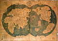 Chinese map, 1763
 -
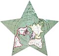 Map in star projektion (1880)


