Category:Can Camps (Ogassa)
Jump to navigation
Jump to search
| Object location | | View all coordinates using: OpenStreetMap |
|---|
building in Girona Province, Spain  | |||||
| Upload media | |||||
| Instance of | |||||
|---|---|---|---|---|---|
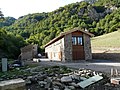
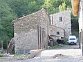
| Location | Ogassa, Ripollès, Comarques Gironines, Catalonia | ||||
| Architectural style | |||||
| Heritage designation |
| ||||
 | |||||
Català: Masia de Can Camps a Ogassa (Ripollès)
This is a category about a building listed in the Catalan heritage register as Bé Cultural d'Interès Local (BCIL) under the reference IPA-4011. |
Media in category "Can Camps (Ogassa)"
The following 6 files are in this category, out of 6 total.
-
 Can Camps P1150552.JPG 3,264 × 2,448; 3.97 MB
-
 Can Camps P1150553.JPG 3,264 × 2,448; 3.83 MB
-
 Can Camps P1150554.JPG 3,264 × 2,448; 3.55 MB
-
 Can Camps P1150555.JPG 3,264 × 2,448; 3.78 MB
-
 Can Camps P1150556.JPG 3,264 × 2,448; 3.66 MB
-
 Can Camps P1150557.jpg 2,448 × 3,264; 2.05 MB


